Ticker for May 27, 2014
MESONET TICKER ... MESONET TICKER ... MESONET TICKER ... MESONET TICKER ...
May 27, 2014 May 27, 2014 May 27, 2014 May 27, 2014
The Big Memorial Day Weekend Rainmageddon 75% update!
Hey, I had to call it something, right? With about another day of big rains to
go (namely, today), we can begin to point out the winners and losers over the
weekend. And winners and losers in the rainfall department as well. Yeah, we're
feeling cheeky with all the rain, but also a bit perturbed at all things
Kardashian as well.
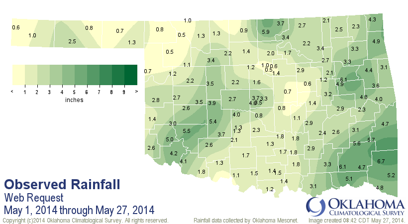
Soooooo, we ran the Mesonet rainfall map for the May 22-about 8:15 am May 27
time period and checked out the results. Obviously, a lot of folks that desperately
needed rain got it, and some by the bucketfuls. Check out the map for that
particular time period.
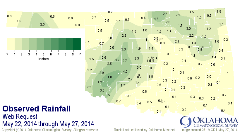
There were two pockets of heavier rainfall from southwest Oklahoma and then up
north into north central Oklahoma (with a few more scattered heavy amounts here
and there. And also a good bit in central Texas County in the Panhandle. Here
are the sites in particular that got a big moisture bounty. Let's just go with
the top-20.
-***-
Hobart 4.78" Skiatook 2.99"
Blackwell 4.26" Retrop 2.93"
Mangum 4.23" Apache 2.89"
Fort Cobb 4.18" Burbank 2.83"
Porter 3.79" Haskell 2.82"
Altus 3.54" Fairview 2.81"
Tipton 3.49" Hinton 2.71"
Watonga 3.30" Butler 2.63"
Weatherford 3.23" Goodwell 2.47"
Minco 3.04" Bessie 2.46"
-****-
As noted, not everybody got great amounts of moisture. Here are the bottom-20.
Not really losers, mind you (since one small town near and dear to my heart
came in so far with a paltry 0.7 inches), but just unfortunately.
-***-
Eufaula 0.21" Hugo 0.08"
McAlester 0.21" Ardmore 0.07"
Centrahoma 0.17" Bowlegs 0.06"
Madill 0.13" Burneyville 0.06"
Sulphur 0.12" Tishomingo 0.06"
Holdenville 0.10" Wister 0.06"
Sallisaw 0.10" Newport 0.05"
Clayton 0.09" Wilburton 0.04"
Talihina 0.09" Stigler 0.02"
Fittstown 0.08" Stuart 0.02"
-****-
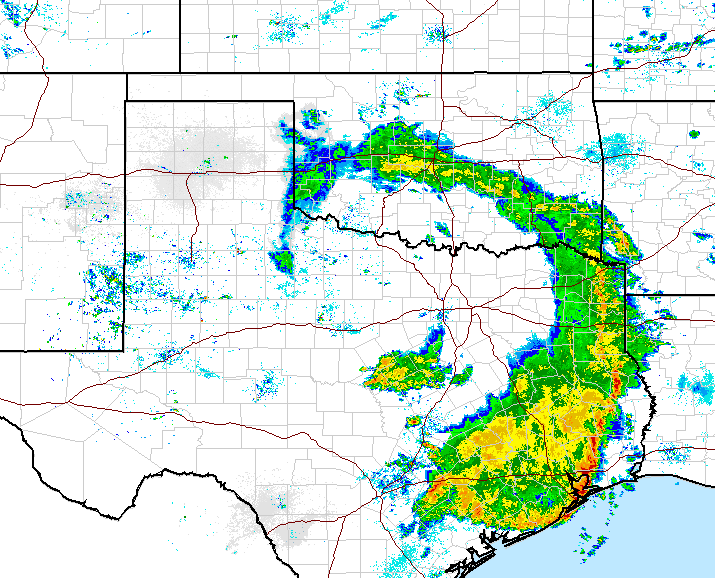
Notice that a lot of those stations are form the eastern side of the state where
the storm really hasn't had an impact yet. Again, this will obviously change
throughout the day as the rain that is currently falling begins to shift that
way. Here is the current radar picture, clearly showing that rotating upper-level
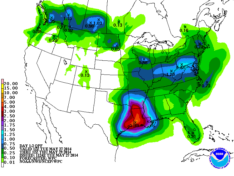
low. We'll throw in the rainfall forecast map as well.
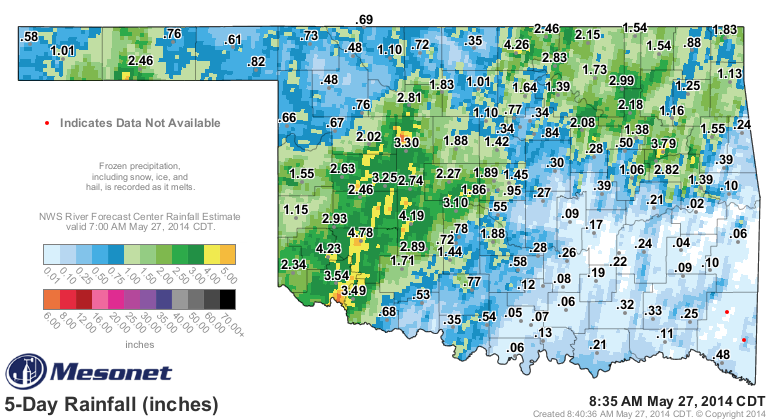
One other thing of note with the current system...so far I've just showed the
Mesonet gauge amounts. Thrown in the gauge/radar estimated amounts and you see
that the heavy rains were a bit heavier in some locations, and just how
widespread they were. There were a few locations that probably exceeded 5 inches.
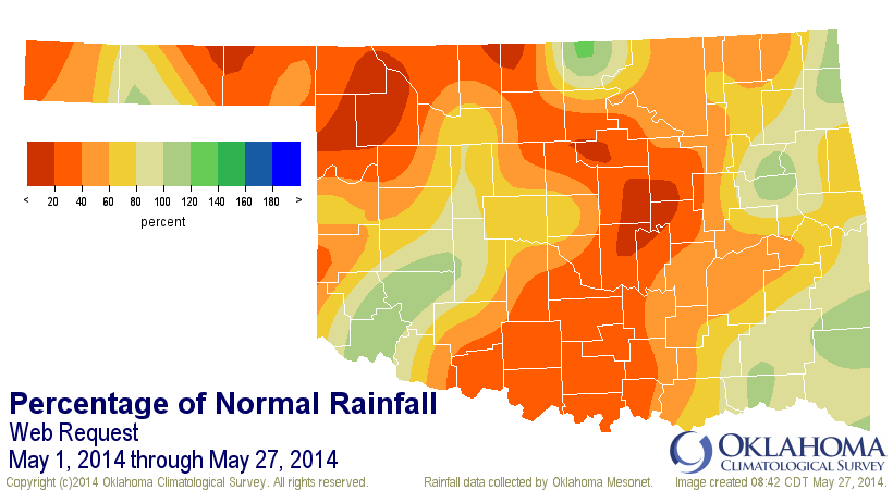
Before we declare this May one of the wettest on record, let's remember, well...
that it's May and we expect a lot of rain this month. So where does this
rainfall (through this morning) bring us up to for the month? It's now *ONLY*
the 25th driest on record since 1921!! WHOO-HOO!!
Okay, enough for now. A lot of these stats will hopefully be moot tomorrow when
we can give the final epitaph (for some, epithet) for this storm system. It's
been gloriously wet for a lot, or will be I hope. Let's hope we can fill in
those drier spots today.
Gary McManus
State Climatologist
Oklahoma Mesonet
Oklahoma Climatological Survey
(405) 325-2253
gmcmanus@mesonet.org
May 27 in Mesonet History
| Record | Value | Station | Year |
|---|---|---|---|
| Maximum Temperature | 108°F | ALTU | 2011 |
| Minimum Temperature | 39°F | KENT | 2009 |
| Maximum Rainfall | 4.32 inches | HOBA | 1999 |
Mesonet records begin in 1994.
Search by Date
If you're a bit off, don't worry, because just like horseshoes, “almost” counts on the Ticker website!