Ticker for April 28, 2014
MESONET TICKER ... MESONET TICKER ... MESONET TICKER ... MESONET TICKER ...
April 28, 2014 April 28, 2014 April 28, 2014 April 28, 2014
One weekend, two tragedies
This weekend's storm system brought severe weather, beneficial rainfall (and the
lack thereof), and unfortunately, the state's first tornado death of the year.
And we do understand that surrounding states and points east got much worse in
the way of tornadic and just plain severe thunderstorm damage ... our thoughts
go out to those folks. But here in Oklahoma, the storms got a big start early
Sunday morning and marched east. Lots of hail damage was reported across central
Oklahoma where ice to the size of golf balls broke windows. The dryline and the
storms continued to march east. One storm dropped a tornado after ramping up
very quickly, hitting the small town of Quapaw in Ottawa County in far NE OK.
The tornado destroyed the town's fire station and killed one resident. The twister
destroyed approximately five businesses and more than 20 residences according
to an account in the Tulsa World.
http://tinyurl.com/tulsa-world-quapaw-tornado
That fatality marks the first for the state during 2014, but also means Oklahoma
has had at least one tornado death in every year starting with 2007 ... 2006 was
the last year Oklahoma failed to experience at least one tornado fatality.
According to preliminary data from the National Weather Service, yesterday's
tornado was the state's third this year, including the two weak twisters that
struck Stephens County back on April 13. There will be no chance for more
tornadoes the rest of the week it appears. The average number of tornadoes from
January-April in Oklahoma (since 1950) is around 17, so Oklahoma's slow start
to the severe weather season continues. As seen by what occurred just to the
east of Oklahoma, however, all it takes is one big day to change those numbers
in a hurry.
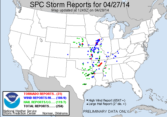
Here is a summary of yesterday's severe storm reports from the Storm Prediction
Center. These are preliminary, but they still indicate Oklahoma escaped the
biggest part of the severe weather outbreak.
-------------------------------------------------------------------------------
The "other" tragedy
Now onto a more benign but just as damaging and costly hazard, the drought. High
hopes were held from far SW OK to points east for this storm system ... not for
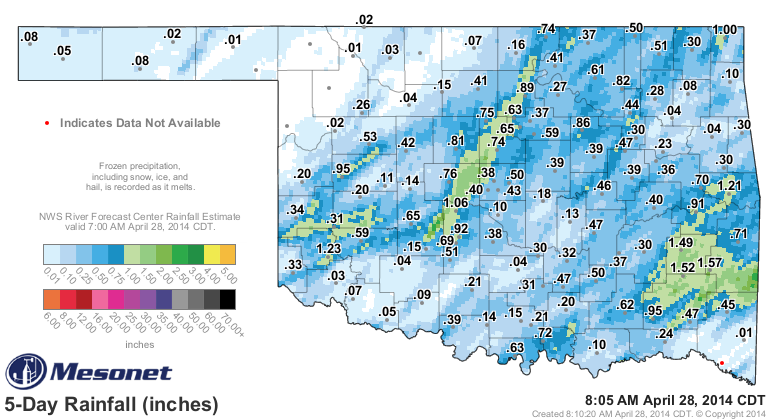
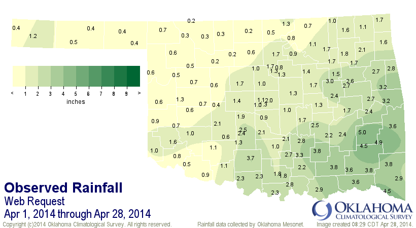
its calamitous weather but for its moisture. And it did rain a bit here and
there. In some areas, more than an inch of rain fell. Combined with a previous
bit of rain earlier in the week and you had at least some color in the Mesonet
rainfall maps.
Those expecting lots of improvement in the drought situation need to realize
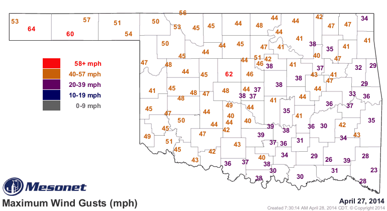
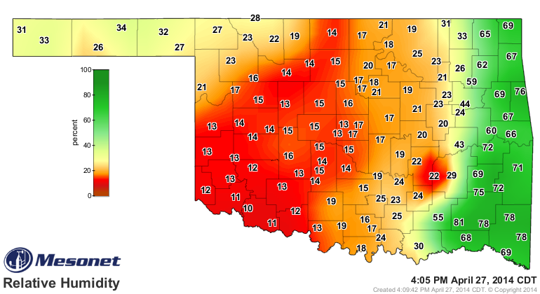
what occurred quickly after that rain. The dryline moved through and the western
half of the state was enveloped by a thick cloud of dust, carried by winds of
over 50 mph and in air with relative humidity down into the low teens. In other
words, a lot of that rain was probably evaporated before it was allowed to
sink into the soil.
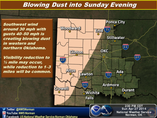
Hopefully some of that rain did manage to soak into the soil and we'll see a
bit of a green-up, because we're now well into spring and the warm season.
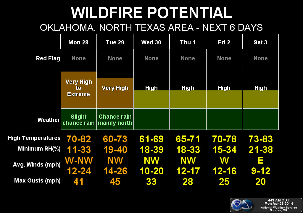
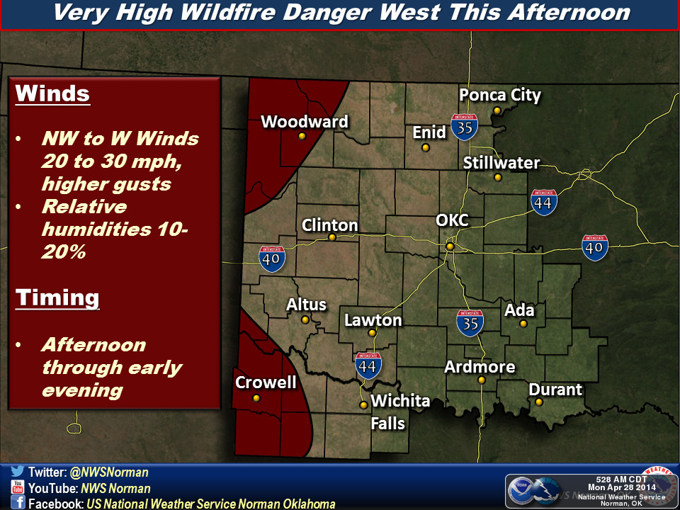
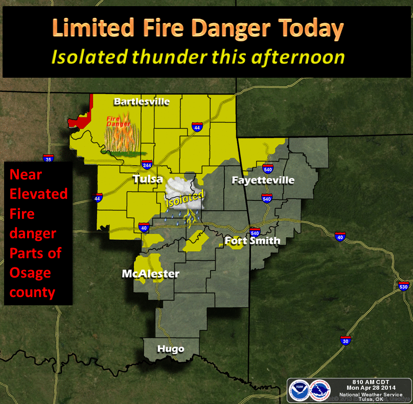
Drought is now a major player in fire danger. The lack of that green-up means
when we get days like we've had over the last few, that fire danger will
skyrocket upwards. And it simply means worsening drought impacts as well. Sure
enough, fire danger will be significant over the next couple of days, and folks
up in the NW will have more blowing dust.
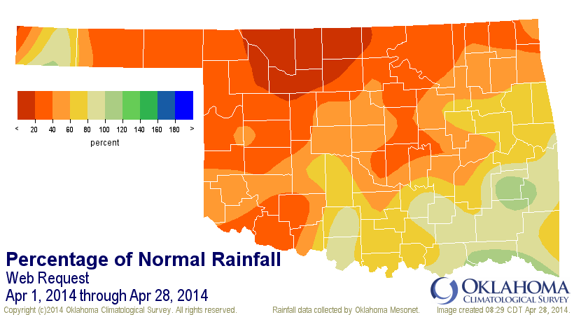
As with the previous three month's before it, April has been a massive dud
when it comes to moisture, helping us to one of our driest first four months of
the year. We've had a statewide average of 1.63 inches for the month thus far,
the 13th driest April 1-28 since at least 1921. For north central Oklahoma and
all that fertile wheat country up that way, it's been the driest on record with
0.52 inches, 2.24 inches below normal (19% of normal). Sixth driest for the NE.
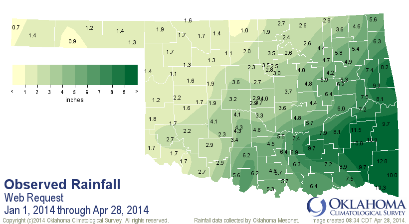
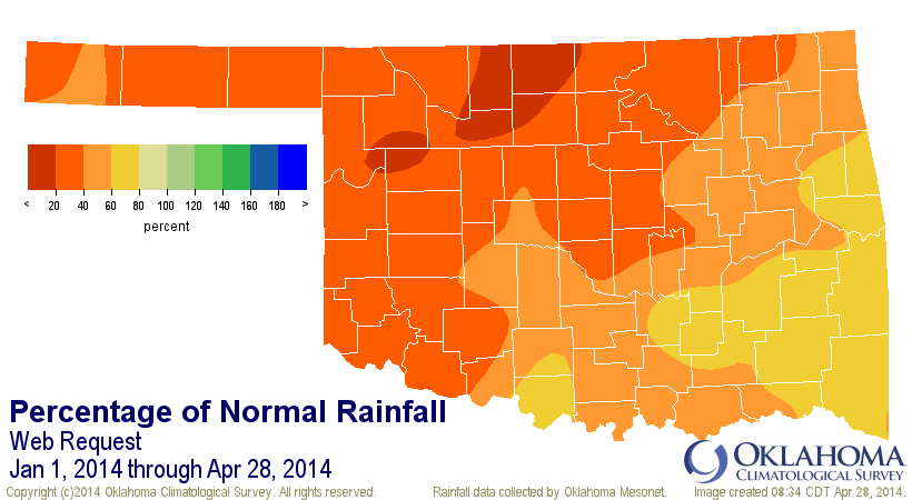
For the year thus far, we've seen the third driest Jan. 1-Apr. 28 since 1921
with a statewide average of 4.21 inches, 5.22 inches below normal. SE OK has
fared "best" with an areal average of 10.12 inches, 4.43 inches below normal
and the 11th driest such period since 1921.
The next week looks mostly dry.
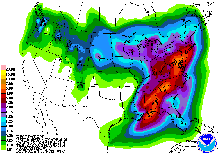
Other than the lack of tornadoes and severe weather, and heat, this spring is
feeling very 2011-12'ish. Like those years, the race is now on to summer as we
have about 6-7 weeks of our primary rainy season left. We can hope for a wet
summer like last year, at least for parts of the state, but normally, Mother
Nature shuts off the spigot right around June 15th or so.
Ladies and Gentlemen ... start your engines.
Gary McManus
State Climatologist
Oklahoma Mesonet
Oklahoma Climatological Survey
(405) 325-2253
gmcmanus@mesonet.org
April 28 in Mesonet History
| Record | Value | Station | Year |
|---|---|---|---|
| Maximum Temperature | 98°F | ALTU | 2020 |
| Minimum Temperature | 27°F | BOIS | 2008 |
| Maximum Rainfall | 6.80″ | MADI | 2006 |
Mesonet records begin in 1994.
Search by Date
If you're a bit off, don't worry, because just like horseshoes, “almost” counts on the Ticker website!