Ticker for April 24, 2014
MESONET TICKER ... MESONET TICKER ... MESONET TICKER ... MESONET TICKER ...
April 24, 2014 April 24, 2014 April 24, 2014 April 24, 2014
Drought overwhelms recent rains

More severe weather last night (doesn't look like anything *TOO* bad, but tell
that to the folks that got the hail and wind), and most importantly, more rainfall.
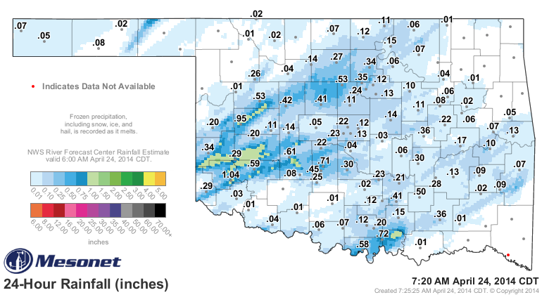
Parts of SW OK got a good dose of at least an inch with Mangum leading the
Mesonet sites down that way with 1.04 inches. You can see from the RFC radar/gauge
overlay that there was a bit wider of an area with an inch surrounding that, but
still much too isolated for widespread drought denting. But, still a good soaking
for some folks and their crops. Amounts diminished pretty rapidly to the east,
however, as the storms died down during the night after the sun said good night.
Coupled with last weekend's storms and the entire state has gotten a bit of
moisture, at least for the most part.
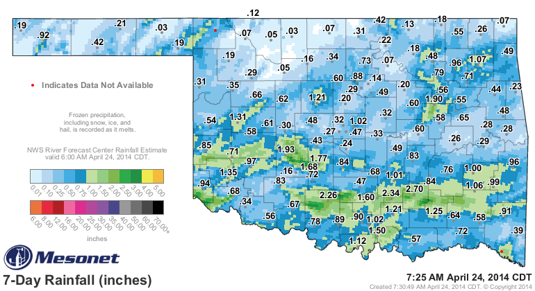
Lots of nice green areas on that map, most localized areas that drive us drought-
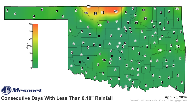
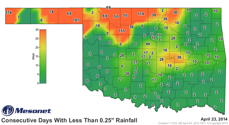
trackers crazy. The most troubling spot remains north central Oklahoma, the state's
most robust wheat-producing area, where they have had less than a tenth with
both storms. Definitely need some more rain up that way. The "days without"
maps show the story for that area.
Even with the recent rainfall, the long-term deficits are dominating the
moisture profile across Oklahoma. Remember, an inch over 7 days this time of
year is basically close to normal, and we need much-above normal rains to
start to alleviate drought. Here is the up-to-the-5minute year-to-date rainfall
maps from the Mesonet to show you that exact picture.
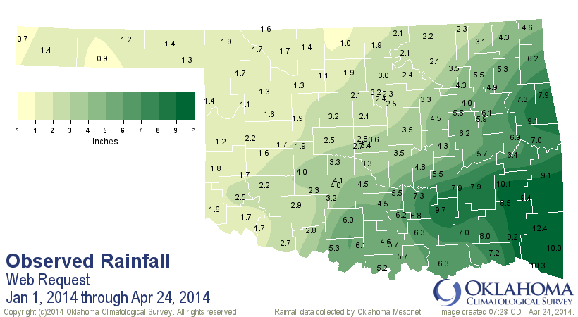
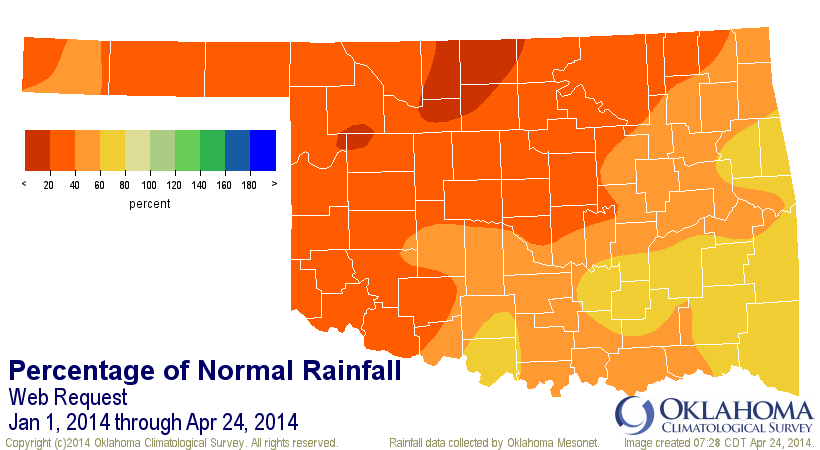
Yikes! Still too much orange and red (less than 40% and 20% of normal) on that
last map. And imagine trying to perk your wheat up with an inch of rain like
Medford has seen (or 0.9 inches in Goodwell).
Take a look at the year-to-date statistics table to see that we are experiencing
one of the driest first four months to begin the year on record, at least dating
back to 1921.
-***-
Climate Div. Total Dep. Normal Pct. Normal Rank since 1921
Oklahoma Statewide 3.99" -5.00" 44% 5th driest
OK-1: Panhandle 1.27" -2.94" 30% 9th driest
OK-2: N. Central 1.65" -5.65" 23% 4th driest
OK-3: Northeast 3.95" -6.82" 37% 2nd driest
OK-4: W. Central 1.64" -4.82" 25% 5th driest
OK-5: Central 3.29" -5.80" 36% 3rd driest
OK-6: E. Central 6.87" -5.30" 56% 9th driest
OK-7: Southwest 2.38" -4.47" 35% 5th driest
OK-8: S. Central 6.14" -4.19" 59% 9th driest
OK-9: Southeast 9.41" -4.55" 67% 10th driest
-****-
5 inches down statewide, and the 5th driest such period on record. The second
driest for northeastern Oklahoma and the 3rd driest for central. North central
comes in at the 4th driest.
Okay, with all that being said, here's the latest U.S. Drought Monitor map.
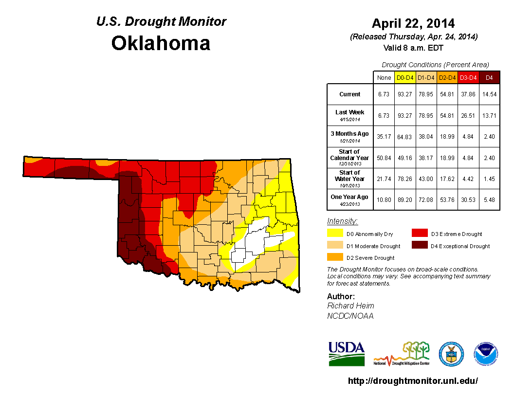
The most obvious change is the large expansion of that Extreme (D3-red) area
eastward across northern Oklahoma. So the amount of D3 drought increased from
12.8% to 23.3% since last week. Everything else stayed the same except for a
minor increase in the Exceptional (D4-maroon) area from 13.7% to 14.5%.
Back on October 1, 2013, only 4.4% of the state was in at least D3 drought, and
only 4.8% since the beginning of the year. Thus, the year-to-date maps above
beget a nasty looking drought monitor. This should not come as a surprise to
anybody.
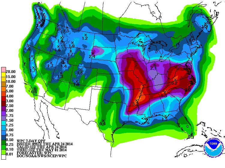
We need this latest rainfall prediction to come true for this weekend, despite
the increased chances for severe weather. Here's the 7-day rainfall forecast.
It looks good, but that's what we've said quite often for months now, only to
get mostly localized decent moisture. We need us a great big honking slow-moving
squall line to move across the state on Saturday, starting on the Texas/New
Mexico border!
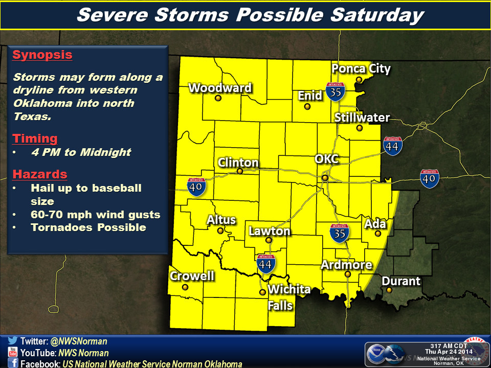
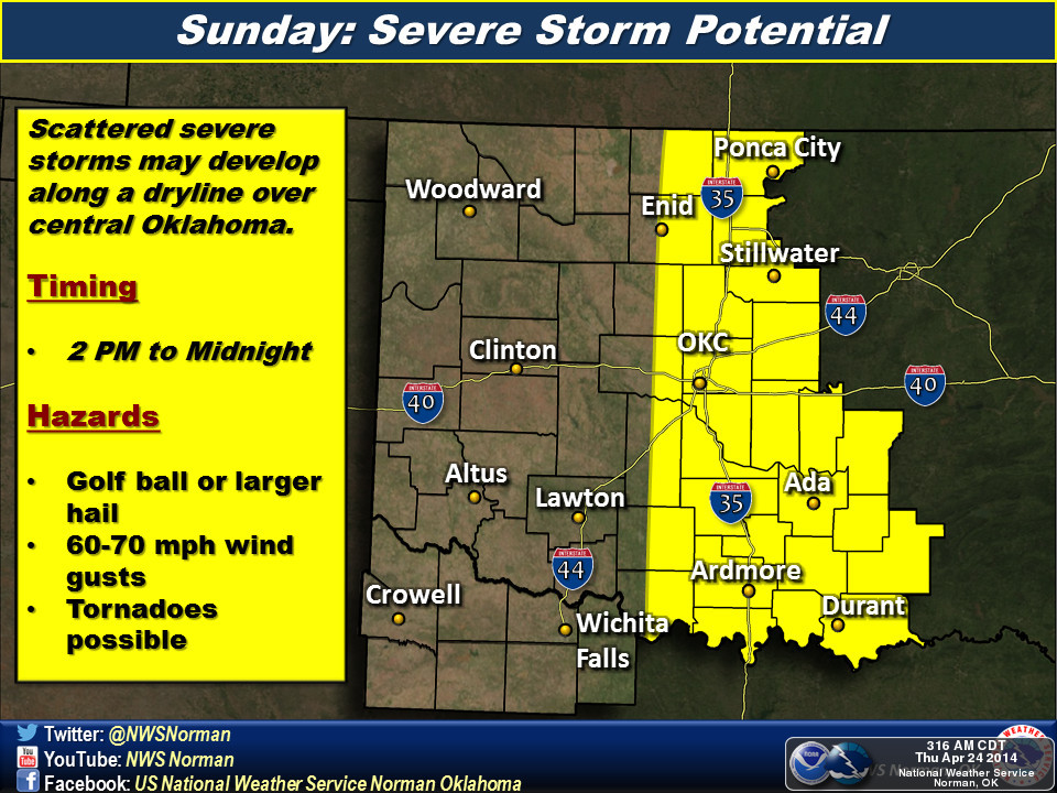
Speaking of those severe weather chances, perhaps it doesn't look like the "big
outbreak" type of situation as it did as of yesterday for the weekend, but that
can change back in a hurry. And tornadoes still look to be a possibility. The
position of the dryline will be a big question mark, as will the timing of
all the ingredients needed to produce the type of shear to get those supercells.
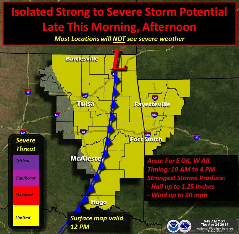
And there is still a chance for storms this morning and today through eastern
Oklahoma.
As always, remain weather aware this weekend. Watch the information from your
local NWS office or your favorite media outlet.
And pray for rain. While you are worried about possible severe weather, lots of
folks from Hollis to Kenton to Blackwell and points in between are faced with
the loss of their wheat, cattle and even in some cases, their drinking water.
Gary McManus
State Climatologist
Oklahoma Mesonet
Oklahoma Climatological Survey
(405) 325-2253
gmcmanus@mesonet.org
April 24 in Mesonet History
| Record | Value | Station | Year |
|---|---|---|---|
| Maximum Temperature | 97°F | BEAV | 2012 |
| Minimum Temperature | 15°F | BOIS | 2013 |
| Maximum Rainfall | 6.77″ | HASK | 2011 |
Mesonet records begin in 1994.
Search by Date
If you're a bit off, don't worry, because just like horseshoes, “almost” counts on the Ticker website!