Ticker for April 14, 2014
MESONET TICKER ... MESONET TICKER ... MESONET TICKER ... MESONET TICKER ...
April 14, 2014 April 14, 2014 April 14, 2014 April 14, 2014
The worst is yet to come?
Severe weather is always bad, although it can sometimes (and often does) bring
something good, like rain. So let's start with the good map, the Mesonet rainfall
maps. And keep in mind that there is freezing precipitation going on across the
northern half of the state, so we will be adding very minor amounts of liquid-
equivalent moisture to this map.
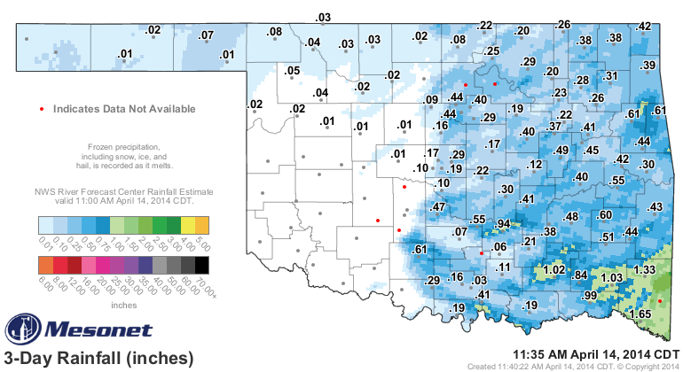
Like a bad script (I'm thinking "Caddyshack II," for instance), this storm system
played out as expected. The storms formed along the dryline and cold front right
up and down the I35 corridor and marched to the east, leaving the western half of
the state somewhat higher (geography rules, there) and definitely drier. You can
see there were some good rains here and there, especially once again down in
McCurtain County. And while that's a somewhat good map (despite the severe stuff),
that leaves us with these maps that aren't so great.
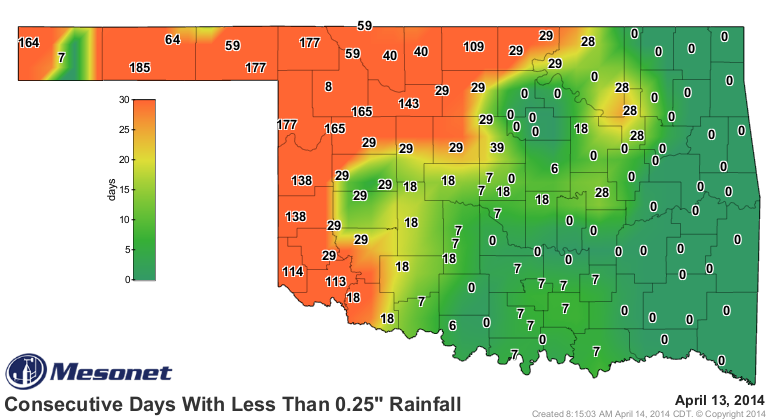
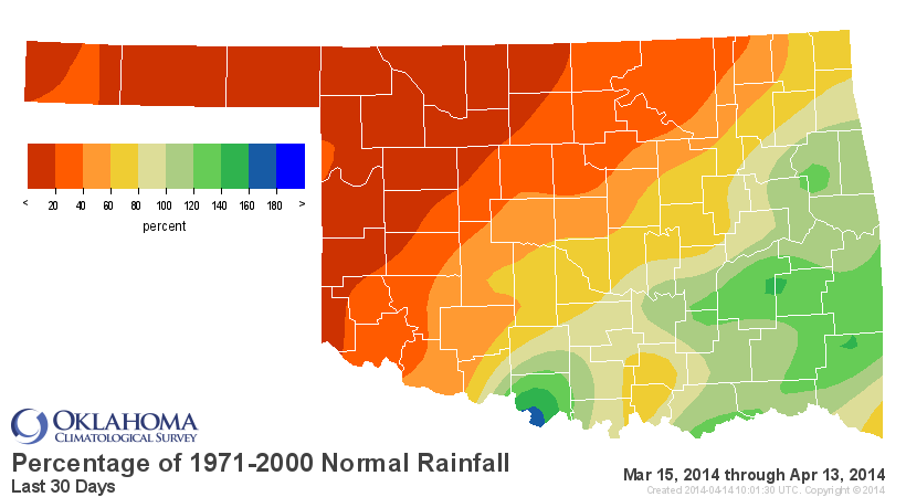
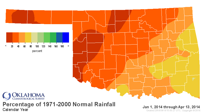
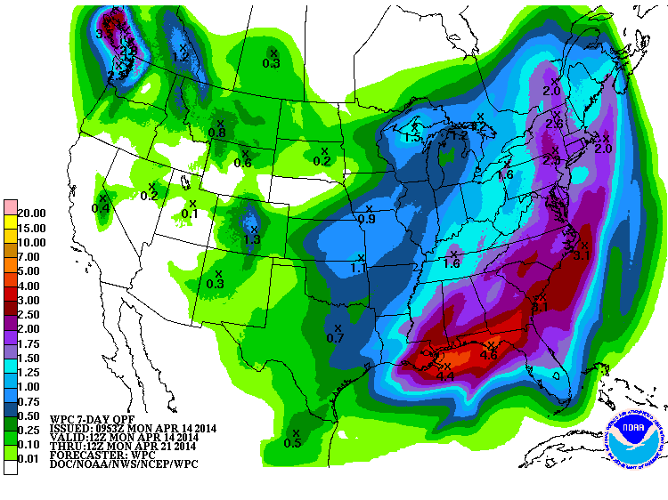
More good news, there will be additional rain chances over the next week. Again,
not as much for the hardest hit drought areas, but at least SOME chances out
that way.
--------------------------------------------------------------------------------
One drought continues, and another ends ... unfortunate news for both. The
tornado drought in Oklahoma reached a total of 248 consecutive days, tying it
for second place in the record books (at least since 1950, when accurate
statistics began) with the 1990-91 streak. Still far behind the 292 days from
May 17, 2003-March 3, 2004 that holds the longest tornado drought. From
preliminary counts only, there appeared to be maybe 2 or 3 very brief tornadoes
that touched down in the state yesterday in Stephens County. That count could
be incorrect so we'll wait a few days for the NWS offices to make any
determinations or confirmation.
Here's your new top-10 (again, contingent on NWS certification)
-***-
Top-10 Consecutive Day Streaks in Oklahoma Without A Reported Tornado
Rank Days Period
1. 292 05/17/2003 - 03/03/2004
2. 248 07/16/1990 - 03/20/1991
2. (4) 248 08/08/2013 - 04/12/2014
4. 234 07/04/1976 - 02/22/1977
5. 220 08/24/1977 - 03/31/1978
6. 200 08/08/1955 - 02/23/1956
7. 193 09/06/1978 - 03/17/1979
8. 189 10/11/1969 - 04/17/1970
9. 188 09/27/1967 - 04/01/1968
10.(t) 187 08/16/1952 - 02/18/1953
08/29/1962 - 03/03/1963
09/22/2006 - 03/27/2007
-****-
--------------------------------------------------------------------------------
And now for the "worst" part. I understand how damaging severe weather can be.
I live 8 streets south of Briarwood Elementary in Moore, after all (actually
SW OKC, but Moore school district). And I also understand yesterday's wind and
hail undoubtedly did damage to structures, cars, etc. But tonight's weather
might be the most damaging of all. Lows right now are forecast to fall into the
20s and low-30s statewide.
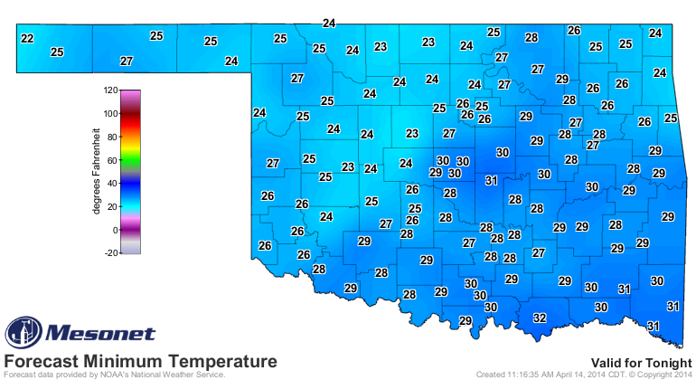
And a lot of our most productive wheat areas are forecast to get into the low-
to mid-20s. Now if it was March, this might not be so bad as the wheat might
not be so far along in its maturity level. But for mid-April, especially when
you add in the stress of drought, this could be, well ... disastrous. As one
Oklahoma wheat expert explained it to me, the drought-stressed plants have less
cell water in the tissue, so they will freeze and rupture more quickly. And the
more stressed areas are the most susceptible, so watch out for SW OK and also
any irrigated wheat that has survived the drought in the Panhandle. Not sure
how much dryland (non-irrigated) wheat is left in either area, given the drought
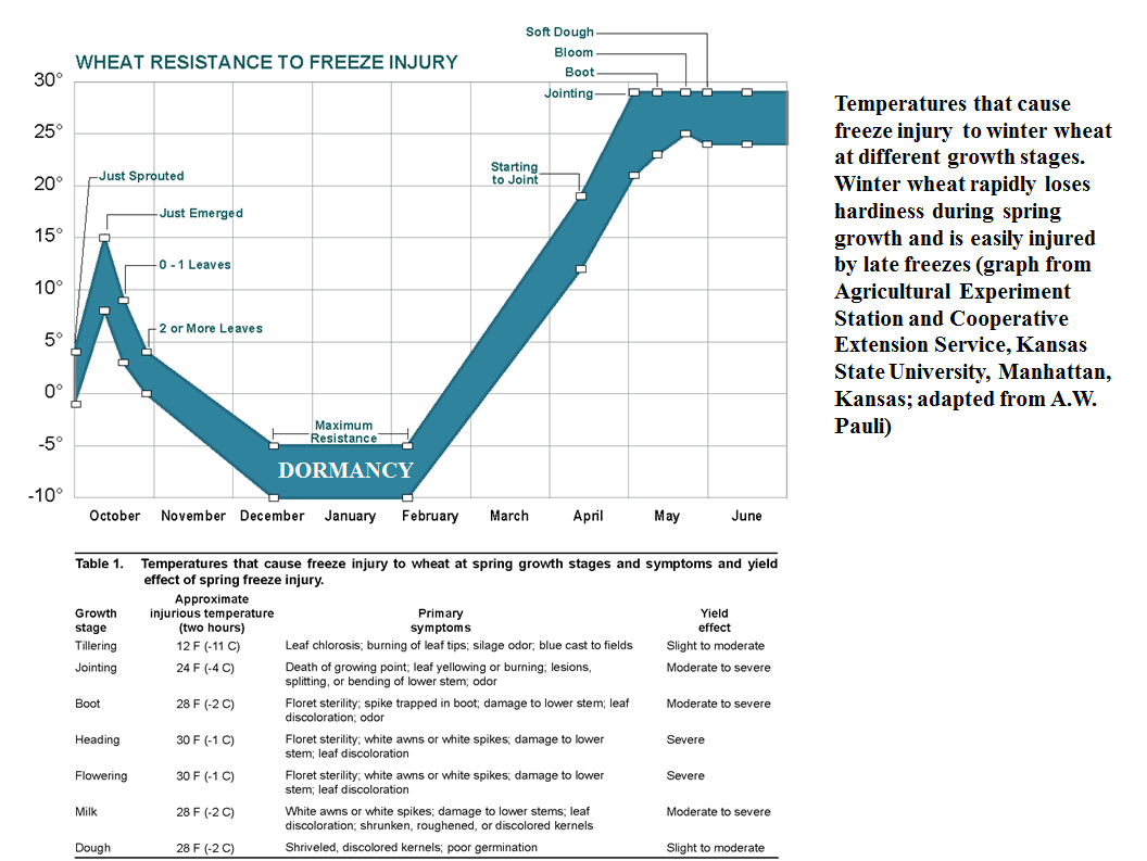
conditions. As shown in this graph from our friends at the USDA, once the wheat
reaches the jointing phase, it's ability to resist even mildly freezing weather
becomes pretty shaky.
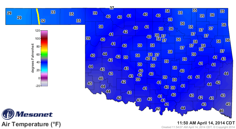
This will be something perhaps not evident for awhile after tonight's freeze,
and of course it will also be contingent on how low it gets and also for how
long. It's still below freezing in the Panhandle, and barely into the 40s
for highs in some areas.
Here is the good news ... it's been fairly cold this year (although extremely
warm lately). So the wheat isn't as far along as it normally is this time of
the year. And some of the wheat in the Panhandle at least has an insulating
layer of snow over it for now. I have no idea if it will last until tonight
because ground temps are fairly warm and it's probably melting fast.
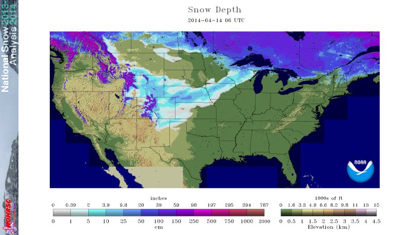
So this is another of those wait-and-see type situations where we won't know
the real damage, if any, until days after the event. Remember, this freezing
weather ain't over until the cold fat lady sings, and she was a hootin' and
a hollerin' into May last year.
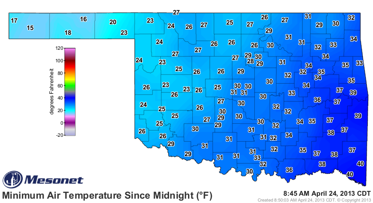
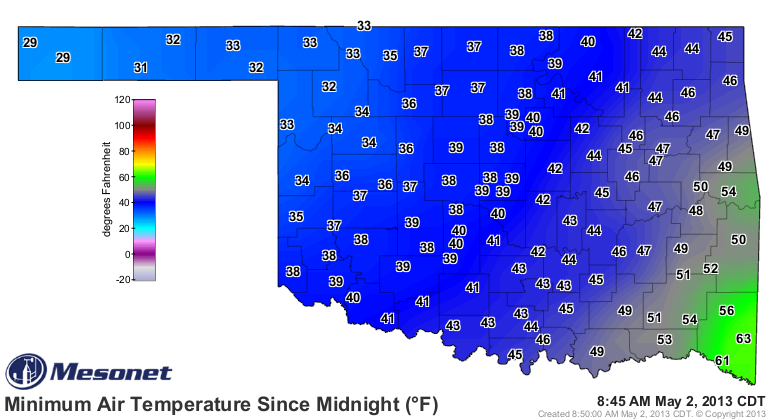
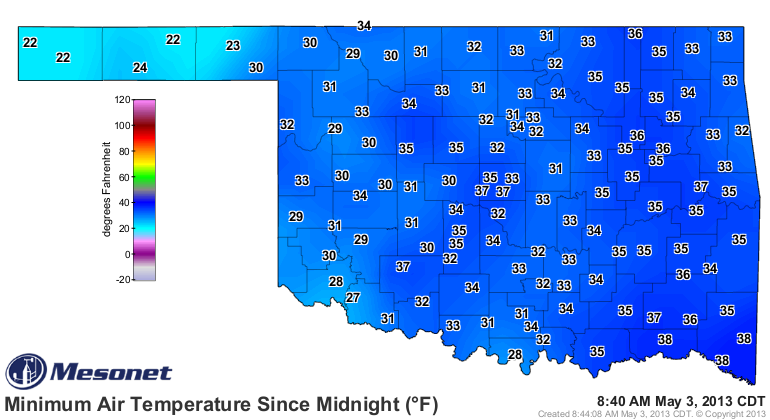
Personally, I wish she would shut up. Didn't Saturday's highs look much better?
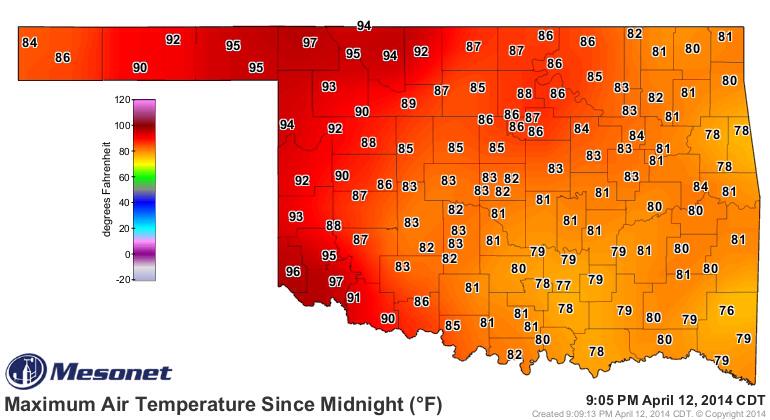
Those readings of 97 degrees in Buffalo and Altus were the highest temperatures
recorded by the Mesonet since four stations hit 97 back on Sept. 26, 2013!
Gary McManus
State Climatologist
Oklahoma Climatological Survey
(405) 325-2253
gmcmanus@mesonet.org
April 14 in Mesonet History
| Record | Value | Station | Year |
|---|---|---|---|
| Maximum Temperature | 97°F | HOOK | 2003 |
| Minimum Temperature | 16°F | EVAX | 2022 |
| Maximum Rainfall | 3.12″ | GUTH | 2012 |
Mesonet records begin in 1994.
Search by Date
If you're a bit off, don't worry, because just like horseshoes, “almost” counts on the Ticker website!