Ticker for March 27, 2014
MESONET TICKER ... MESONET TICKER ... MESONET TICKER ... MESONET TICKER ...
March 27, 2014 March 27, 2014 March 27, 2014 March 27, 2014
Drought Grows Despite Recent Rains
The dust storms, wildfires and reports of struggling crops and pastures that have
plagued the state over the last few weeks are evidence that drought has continued
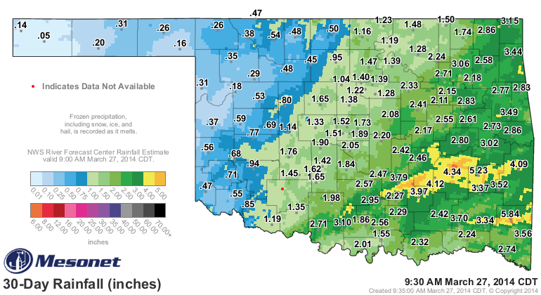
to strengthen across Oklahoma. Recent rains did help curb the drought's growth
across a few select areas, mainly in south central and southeastern Oklahoma
where 3-5 inches fell over the last 30 days.
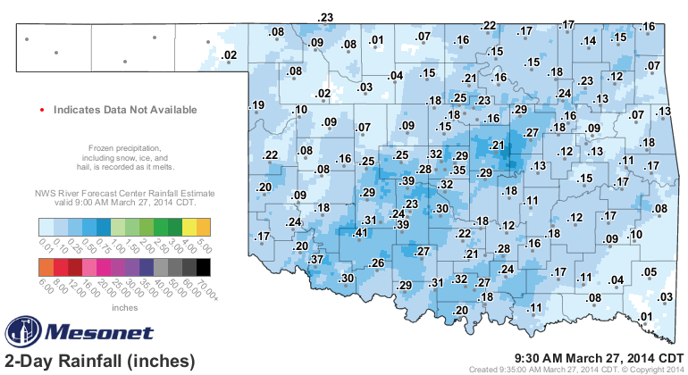
Up to a half-inch of moisture fell in localized areas on March 26, but most of
the state recorded less than a quarter-inch.
That continued lack of moisture has allowed the drought, which had been growing
slowly but steadily through the dry winter, to intensify more quickly as we
entered spring. The latest U.S. Drought Monitor report released Thursday
morning indicated a significant increase in extreme to exceptional drought
across the western third of Oklahoma, now encompassing 24 percent of the state.
That's an increase of nearly 10 percent in just the last week, and 20 percent
since October 1, 2013. Moderate to severe drought covered approximately 53
percent of the state and nearly 19 percent was considered to be in "Abnormally
Dry" conditions. Only four percent of Oklahoma was portrayed devoid of any dry
conditions.
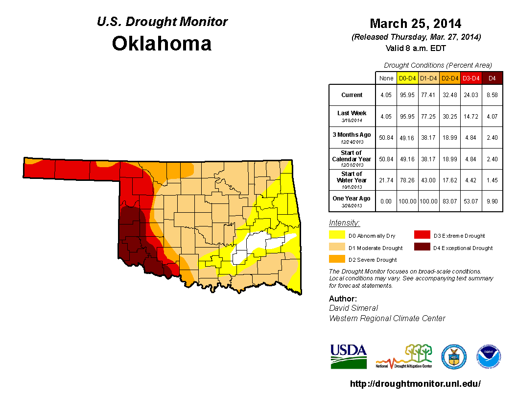
The Drought Monitor?s intensity scale slides from moderate-severe-extreme-
exceptional, with exceptional being the worst classification. Abnormally dry
is not a drought intensity, but can signify areas that are approaching or
escaping the moderate drought category.
March has seen a continuation of dry weather that began late last summer and
deepened through the winter. The climatological winter (December-February) was
the 11th driest on record across the state, dating back to 1895, with an
average deficit of nearly 3 inches. Central Oklahoma suffered its ninth driest
winter on record at 3.65 inches below normal.

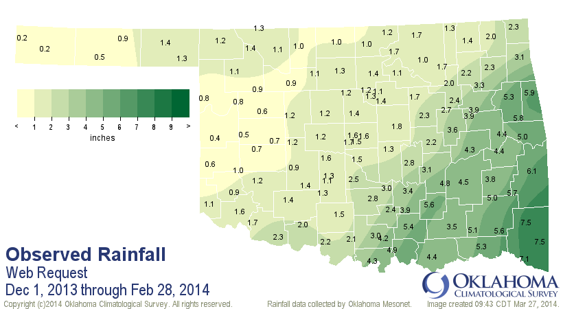
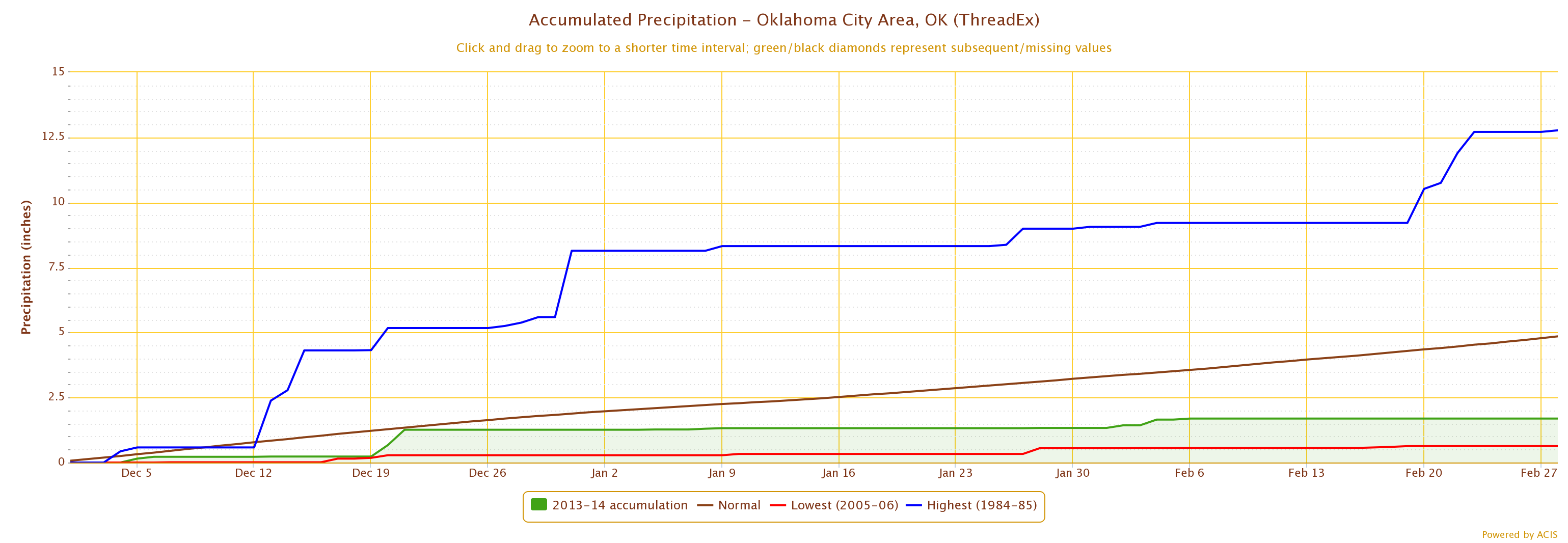
Oklahoma City's December-February total of 1.69 inches was its ninth lowest
total since records began back in the winter of 1890-91, 3.16 inches below
normal.
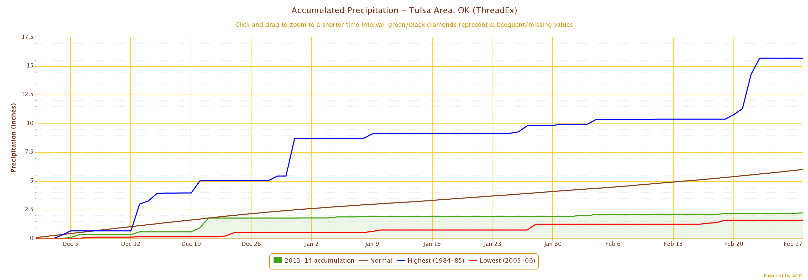
Tulsa fared a bit worse in the rankings with a total of 2.23 inches, a deficit
of 3.77 inches for their sixth driest winter on record dating back to 1893-94.
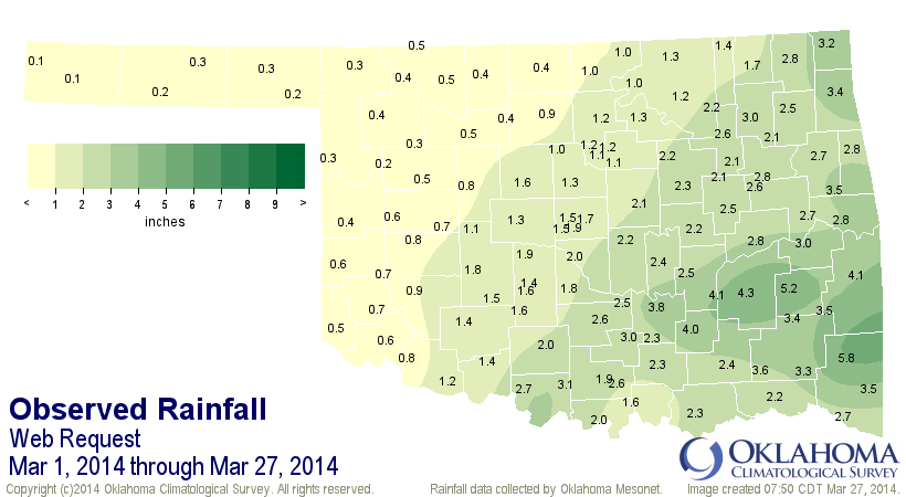
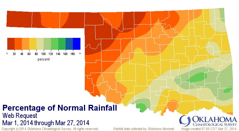
March has not been much of a help outside of south central and southeastern
Oklahoma. Most of the northwestern half of the state has received less than an
inch of rainfall for the month thus far, from 40 percent to less than 20 percent
of normal over that time frame. The Oklahoma Mesonet sites across far western
Oklahoma and the Panhandle have recorded less than a half-inch through March 27.
The impacts from the drought intensification are both subtle and obvious.
Massive dust storms, fueled by the barren, drought-afflicted fields across the
High Plains from Colorado down through Texas, have reminded some of the 1930s
Dust Bowl days. Wildfires have been a particular problem since January,
associated with an abundance of days with low humidity and high winds, weather
patterns which also act to accelerate drought intensification. The latest
"Oklahoma Crop Weather" report released on March 24 from the USDA's National
Agricultural Statistics Service indicated 42 percent of Oklahoma's winter wheat
crop was in "Poor" to "Very Poor" shape, an increase from 24 percent in those
two categories from early February. The latest report categorized 72 percent of
the state's topsoil and 80 percent of the subsoil to be "Short" to "Very Short"
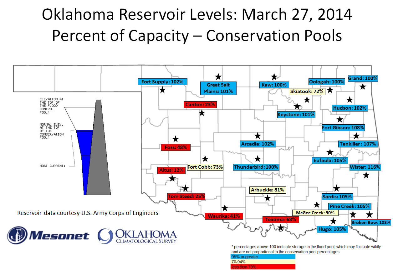
of moisture. Most lakes across western Oklahoma remain in perilously depleted
conditions. Tom Steed Lake, the main water supply reservoir for the city of
Altus, is down to 25 percent of normal capacity. Nearby Lake Altus-Lugert, an
important supplier of agricultural irrigation, is down to approximately 11
percent of capacity. Canton Lake and Foss Lake are down to 23 percent and 48
percent, respectively. Even a few bigger reservoirs outside of western Oklahoma
show serious impacts of the long-term drought. Skiatook Lake in northeastern
Oklahoma is approximately 10 feet below normal at 72 percent, and Lake Texoma
along the border with Texas is at 67 percent.
The key to drought recovery is an active spring rainy season. Twenty years of
statewide rainfall data from the Oklahoma Mesonet pinpoint Oklahoma's primary
rainy season to be from mid-April through mid-June, although a secondary rainy
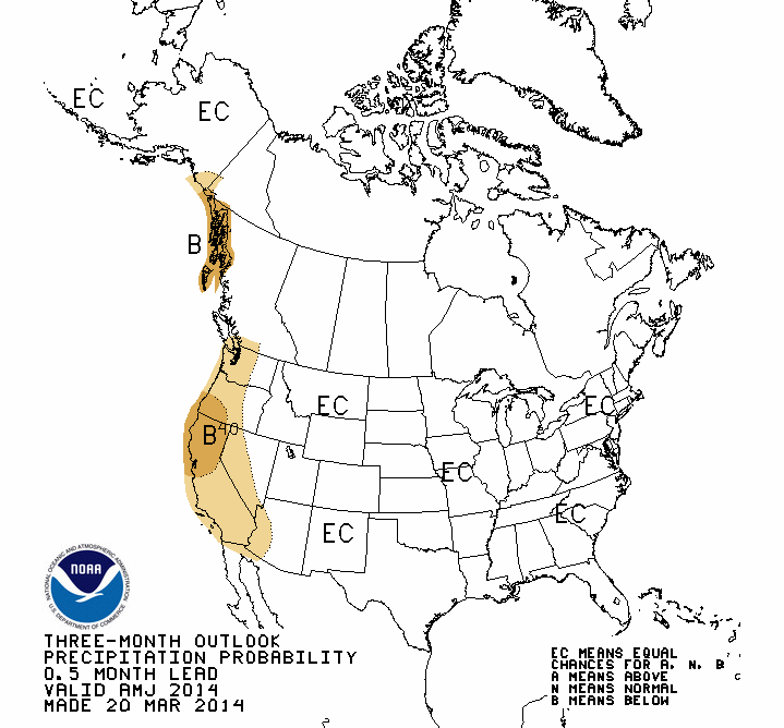
season can be found during the fall months. The latest April-June outlooks from
the National Weather Service's Climate Prediction Center (CPC) provide no clues
for spring rain chances. The state is portrayed in the "Equal Chances" category,
which means the forecasters see equal chances of above-, below- and near-normal
precipitation amounts in the absence of any strong climate indicators.
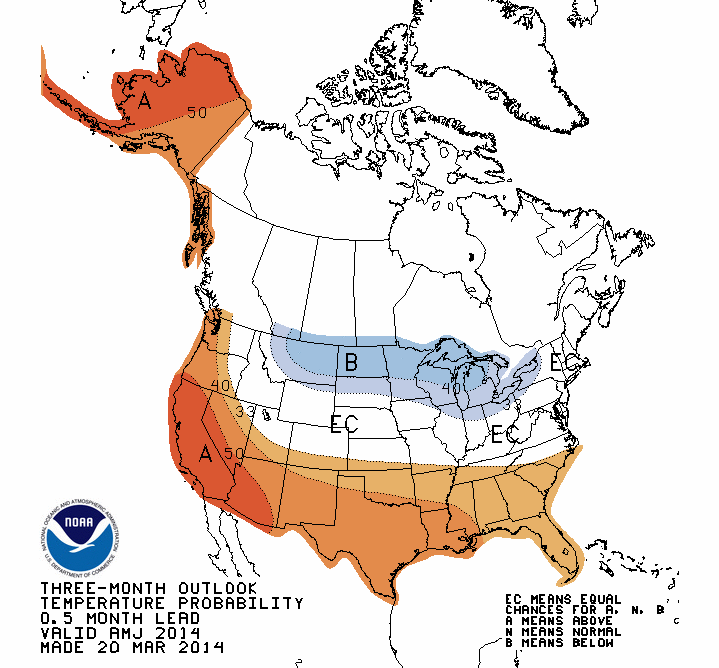
The forecasters do see increased odds for above normal temperatures across the
state during spring.
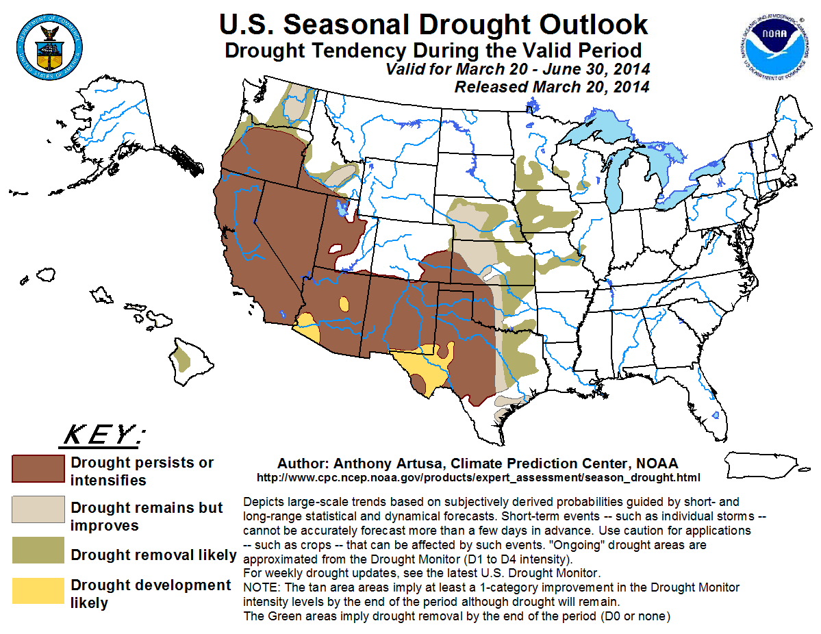
CPC's U.S. Seasonal Drought Outlook for that same period has encouraging news
for the eastern half of the state with "drought remains but improves" indicated
for the I35 corridor and "drought removal likely" farther to the east. A dreary
prediction for the western half of the state, however, with "drought persists
or intensifies" forecast for that area.
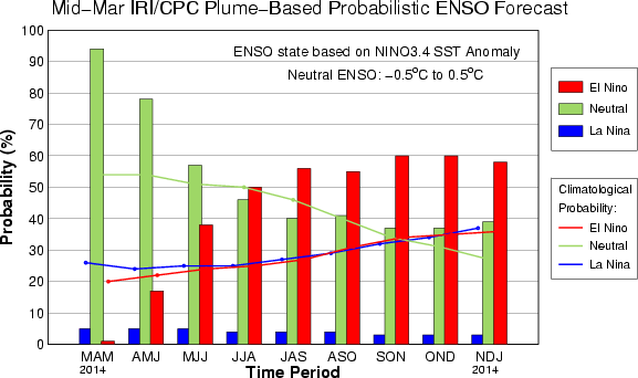
In the longer term, CPC experts continue to see good chances of El Ni?o
developing this summer and possibly lasting into the next fall and winter.
CPC issued an El Ni?o watch earlier this month indicating conditions are
favorable for the development of El Ni?o conditions within the next six months.
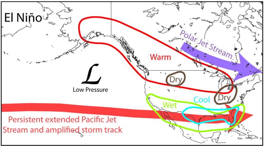
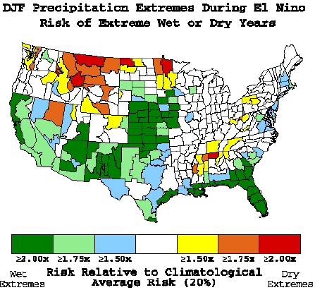
This warming of the ocean waters in the equatorial pacific often brings the
southern tier of the United States cooler and wetter weather during the cool
season, October through April.
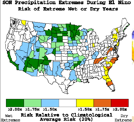
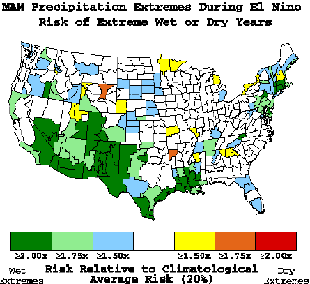
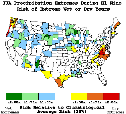
Many experts think this could be a particularly strong El Ni?o, which would be
important for Oklahoma since a weak or moderate El Ni?o would diminish the
chances for above normal precipitation. Historical precipitation data suggest
a weak El Ni?o could bring dry weather to the state. El Ni?o has little impact
across Oklahoma outside of the cool season.
Gary McManus
State Climatologist
Oklahoma Climatological Survey
(405) 325-2253
gmcmanus@mesonet.org
March 27 in Mesonet History
| Record | Value | Station | Year |
|---|---|---|---|
| Maximum Temperature | 91°F | WAUR | 2008 |
| Minimum Temperature | 11°F | KENT | 2005 |
| Maximum Rainfall | 3.74″ | STIG | 2018 |
Mesonet records begin in 1994.
Search by Date
If you're a bit off, don't worry, because just like horseshoes, “almost” counts on the Ticker website!