Ticker for March 4, 2014
MESONET TICKER ... MESONET TICKER ... MESONET TICKER ... MESONET TICKER ...
March 4, 2014 March 4, 2014 March 4, 2014 March 4, 2014
Line 'em up!
Fresh off our 73rd winter storm this season (I'm prone to exaggeration), it would
appear we have a couple more storms lined up for the coming week. They don't
appear to be so disrupting, but that's what folks used to say about me and look
what happened.
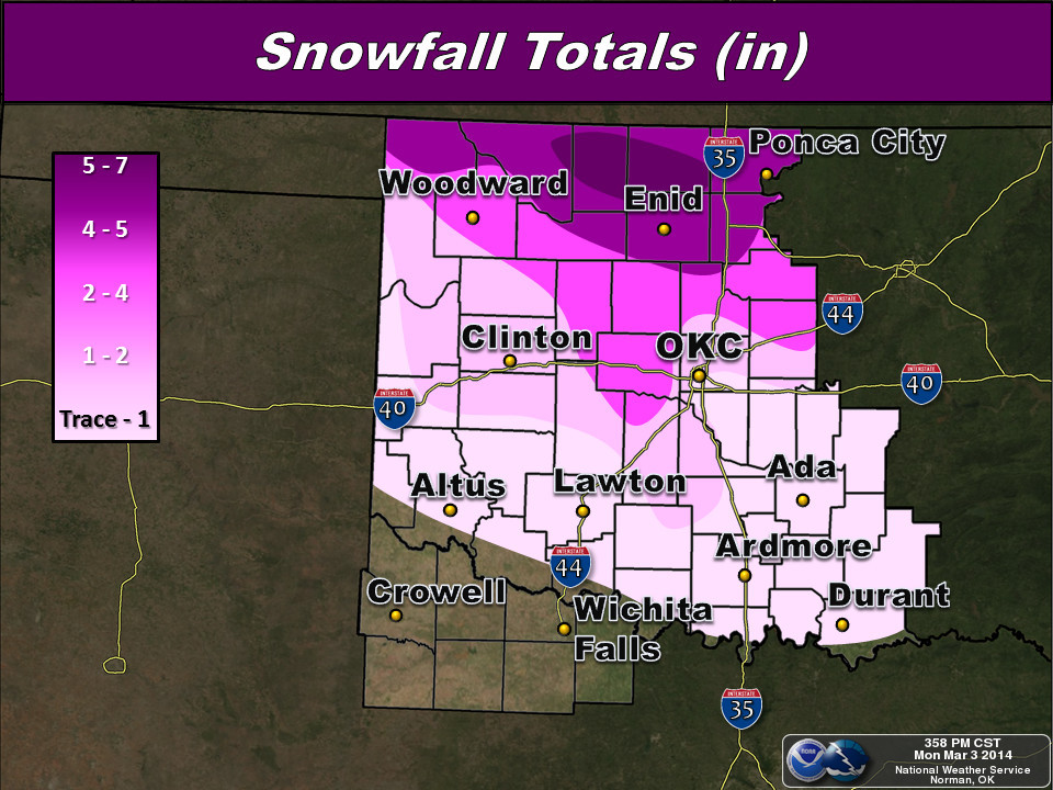
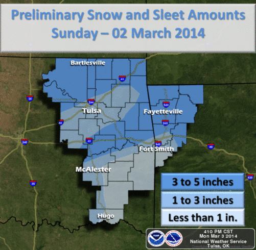
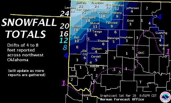
This last storm packed quite a wallop and the totals reflect that. Now a lot of
the snow totals were brought down by sleet and freezing drizzle/rain, but still
some pretty impressive amounts. Here are the totals from the local NWS offices.
North central Oklahoma was the bullseye with 5-7 inches, it appears.
The real pleasure (sarcasm intended) with this storm was the nice, bracing arctic
air that came with it. Lows the last couple of days have plunged into record
for some parts of the state ... danged cold for March! Buffalo reached a record
low of -7 degrees yesterday, which also tied for the coldest reading ever on
March 3rd in Oklahoma, dating back to the 1890s or so.
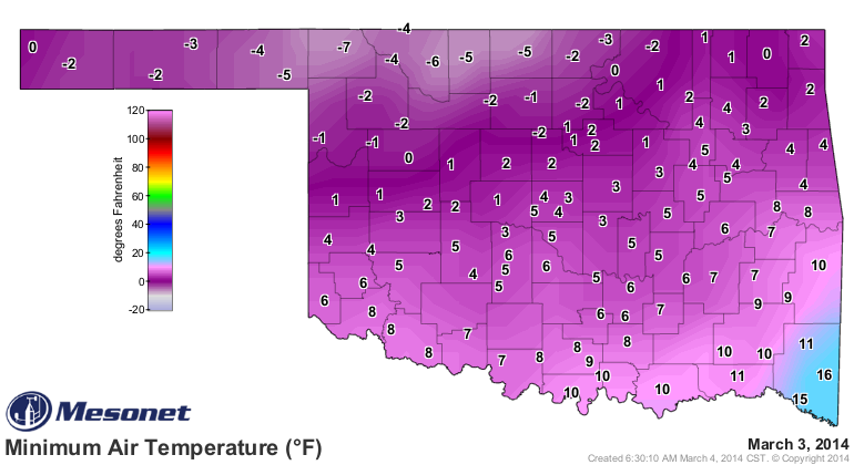
Here are those "lowest lows" records for March 3 ... MOVE OVER 1943 and 1960,
there's a new sheriff in town (or at least a Deputy). The lowest temperature
ever recorded in March in Oklahoma was -18 degrees, from what I can dig around
and find. That occurred back on March 6, 1948.
-***-
-7 HOOKER 1943
-7 BUFFALO (Mesonet) 2014
-6 BEAVER 1960
-6 BOISE CITY 2 E 1960
-6 REYDON 2SSE 1960
-6 ALVA (Mesonet) 2014
-5 CHEROKEE (Mesonet) 2014
-5 SLAPOUT (Mesonet) 2014
-5 MEDFORD (Mesonet) 2014
-5 GAGE 1960
-5 GOODWELL 1960
-5 MUTUAL 1960
-5 TAHLEQUAH 1943
-5 WATTS 1943
-****-
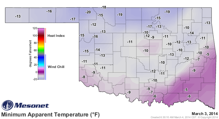
Add the wind and the wind chills were even worse yesterday, obviously. While
many of the Mesonet wind sensors were encased in ice (and therefore not able
to provide a wind for the calculation of wind chills), we still saw the values
drop to as low as -20 degrees at Buffalo.
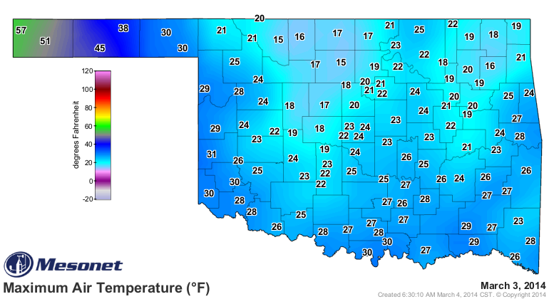
What's more, the 15 degrees recorded as highs at Alva and Breckinridge tied the
all-time record for that particular parameter, matching the 15 degrees recorded
for a high at Alva back in 1960.
Things were a little better this morning, but you can at least see where the
snowpack is at its heaviest up across northern Oklahoma.
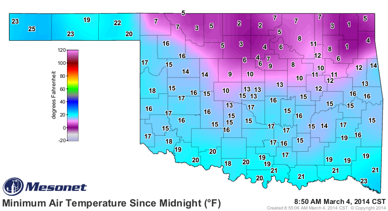
One degree readings in Vinita and Pryor can't match yesterday's readings, but
they're hypothermic nonetheless.
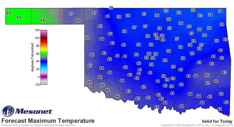
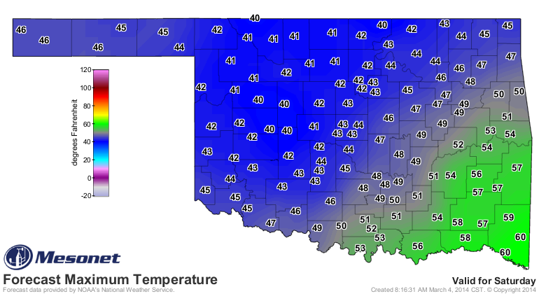
Today's highs are predicted to rise from record-low territory to *just* well
below normal. Get yourself to Cimarron County and you'll enjoy 60 degrees.
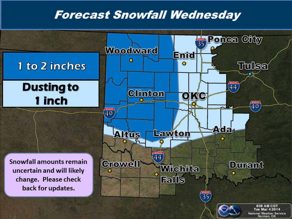
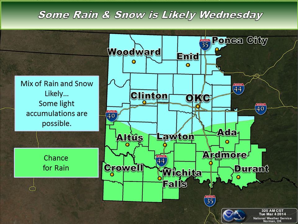
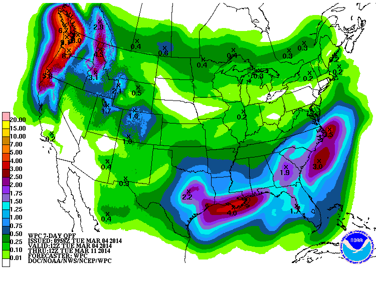
Our next storm that will bring us some moisture (some snow, some rain, some
mix) hits on Wednesday. Here are how the local NWS offices see it. Looks like
we should get above freezing long enough to prevent major travel problems, so
if you know any majors traveling on Wednesday, let them know it's okay.

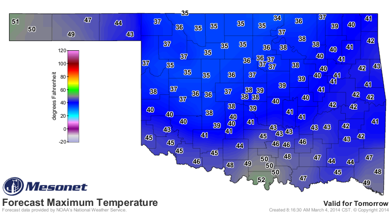
Then we have Friday to look forward to
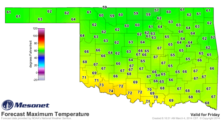
before the next system on the weekend moves in. Again, doesn't look cold enough
to be a major travel disruptor, other than maybe up north on Friday night as
the front moves in.
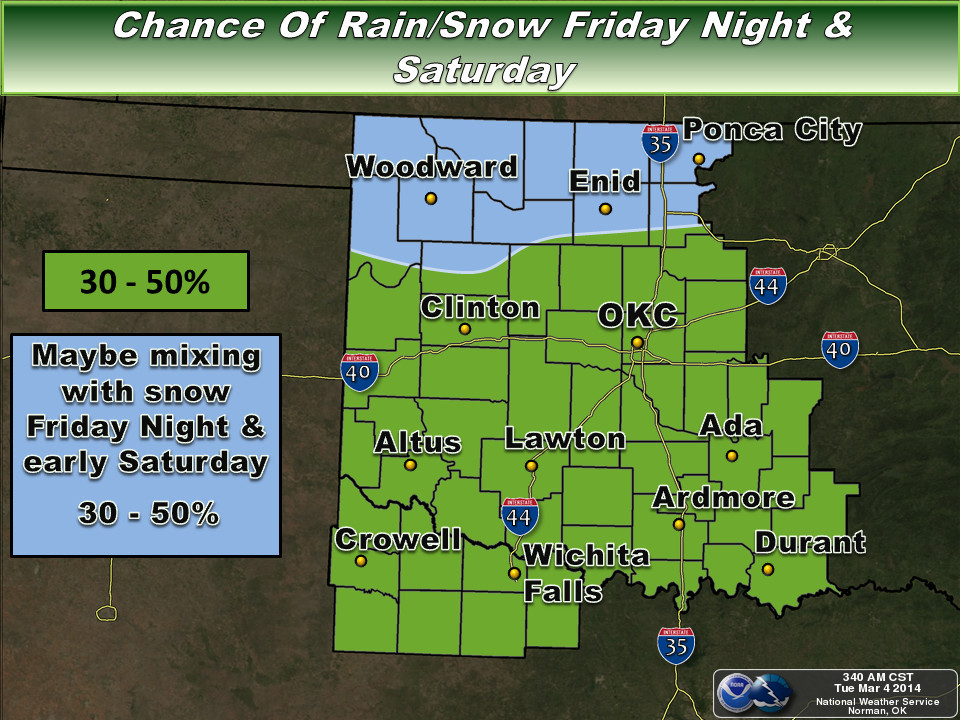
Altogether, it appears we might be in for another half-inch or so of moisture
across most of the state, with maybe more across the far south.
I'll guarantee ya (unless it doesn't happen) that winter isn't done with us just
yet. It just looks like it's going to be one of those years. Remember this?
Heck, last year it snowed in May!
Gary McManus
State Climatologist
Oklahoma Climatological Survey
(405) 325-2253
gmcmanus@mesonet.org
March 4 in Mesonet History
| Record | Value | Station | Year |
|---|---|---|---|
| Maximum Temperature | 91°F | HOLL | 2009 |
| Minimum Temperature | -5°F | VINI | 2002 |
| Maximum Rainfall | 5.31 inches | KING | 2004 |
Mesonet records begin in 1994.
Search by Date
If you're a bit off, don't worry, because just like horseshoes, “almost” counts on the Ticker website!