Ticker for February 27, 2014
MESONET TICKER ... MESONET TICKER ... MESONET TICKER ... MESONET TICKER ...
February 27, 2014 February 27, 2014 February 27, 2014 February 27, 2014
FROZEN DROUGHT-POCALYPSE 2014!
Two big weather stories going on today, so we might as well get the 800-pound
gorilla (I heard that ... gorillas have hair so your jokes won't work) out of the
way first and deal with ICE-POCALYPSE 2014(!!!) first. What's gonna happen is
we're gonna get a real nasty shot of cold air on Saturday overnight into Sunday
and then moisture from the Gulf of Mexico is going to run up over the top of that
and produce some type of frozen/near-frozen precip from Saturday into Sunday. For
now, I'll just show you what the NWS folks are saying.
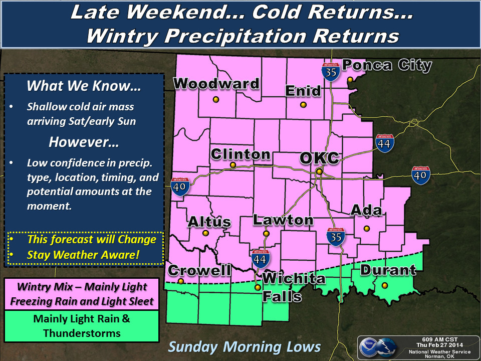
And from the local offices' forecast discussions. It must be important because
they keep yelling at us:
NWS-Norman: " ... IT APPEARS ALL OF THE ABOVE WILL SUPPORT ICE ACCUMULATION
ACROSS PORTIONS OF CENTRAL AND SE OK. IT IS DIFFICULT TO TELL HOW
MUCH WILL OCCUR...BUT WITH TEMPS EXPECTED TO RAPIDLY FALL THROUGH
MON AM SUSPECT THERE WILL BE SOME TRAVEL PROBLEMS. FURTHER TO THE
NORTH...MORE MID TO UPPER MOISTURE WILL SUPPORT SNOW AND SLEET
NEAR N/NW OK SUNDAY. THE MOST SIGNIFICANT ACCUMULATIONS WILL
LIKELY REMAIN NORTH OF OUR (Forecast Area)...BUT AGAIN SOME SLICK CONDITIONS
WILL DEFINITELY BE POSSIBLE."
NWS-Tulsa: "TEMPERATURES WILL QUICKLY DROP BEHIND THE FRONT AND PRECIPITATION
WILL INITIALLY BEGIN AS FREEZING RAIN SATURDAY NIGHT...TRANSITIONING
TO SLEET ACROSS NE OK DURING THE DAY SUNDAY AS THE COLDER AIR
SURGES IN THE AREA. STILL SOME UNCERTAINTY CONCERNING ICE/SLEET
AMOUNTS AND THIS WILL LIKELY DEPEND ON HOW QUICKLY DRY SLOT MOVES
OVER DURING THE DAY SUNDAY. MOST OF THE PRECIPITATION IS EXPECTED
TO FALL AS FREEZING RAIN AND SLEET WITH LIMITED SNOW ACCUMULATIONS
SUNDAY NIGHT BEFORE ENDING BY MONDAY MORNING. PERSONS SHOULD MONITOR
THE FORECASTS INTO THE WEEKEND AS ICE/SLEET AMOUNTS CONTINUE TO BE
REFINED."
One of the problems here is that what falls on Sunday into Monday morning might
stick for awhile since the cold air is going to stick around, creating travel
problems that morning.
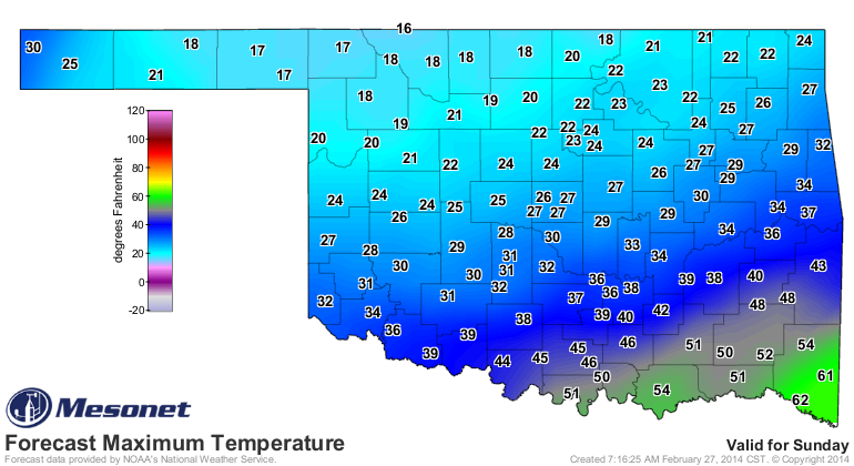
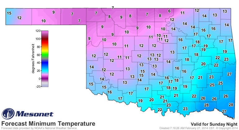
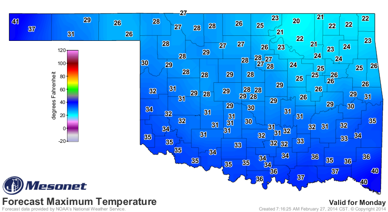
For those of you not on the Mesonet's Facebook page (and why aren't you? give
us a like! Also, how long has it been since you've had a big, steaming bowl of
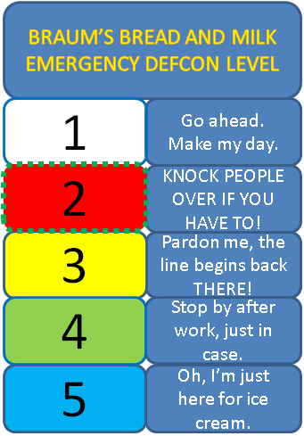
Wolf Brand Chili??), you probably missed that we raised the DEF-BRAUM'S level to
LEVEL FOUR. Now that ice looks more likely, and the frigid air is a certainty,
we're ready to raise that level to LEVEL TWO!
What a lovely start to March.
-------------------------------------------------------------------------------
Drought Continues to Advance across Oklahoma
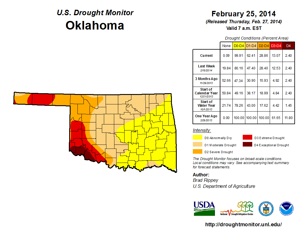
The newest Drought Monitor map says it all, with all of those lovely non-dry
white areas disappearing off the map from last week to this week. So for the
first time since September 10, 2013, all of Oklahoma is back into at least the
Abnormally Dry (D0) designation. Now keep in mind that D0 is not a drought
specification, but it does signify areas headed towards drought without
intervening precipitation. It can also be used to show areas COMING OUT of
drought (D1-D4), but that's not the case here. Additionally, The amount of
Moderate (D1) drought increased from 19% last week to 34% this week, mostly
across north central and NE Oklahoma. In all, the amount of the state within
some drought intensity (D1-D4) increased from 47% to 62%.
We've talked about the reasons for this cool-season intensification of drought
several times recently ... simply put, we've had one of the driest winters on
record this year. And that's on top of pressures put on the state from the
previous three years of persistent drought (inter-mixed with periods of relief)
across the eastern two-thirds of the state.
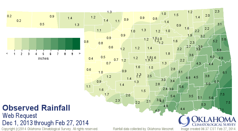
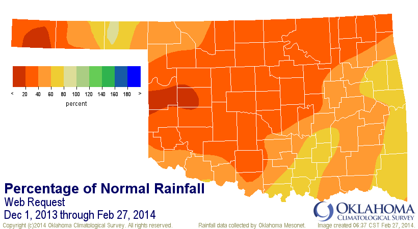
Preliminary data from the Oklahoma Mesonet shows that climatological winter
(December 1-February 28) is going to finish somewhere around the 11th driest
on record with a statewide average of 2.31 inches, nearly 3 inches below
normal. Here are the top-12 driest winters dating back to 1895 in Oklahoma
(actually top-13 with this year thrown in).
-***-
Rank Winter Period Statewide Avg.
1 1908 - 1909 1.24"
2 2005 - 2006 1.56"
3 1917 - 1918 1.67"
4 1962 - 1963 1.90"
5 1900 - 1901 2.04"
6 1916 - 1917 2.05"
7 1975 - 1976 2.12"
8 1966 - 1967 2.19"
9 1901 - 1902 2.21"
10 1958 - 1959 2.22"
11 2013 - 2014 2.31"
12 1903 - 1904 2.54"
13 2010 - 2011 2.68"
-****-
I wanted to get 2010-11 in there because that's the period where this whole
mess really got it's start, so you can see just how little this dry winter has
helped the situation any. For specific areas of the state, such as NE, central
and west central Oklahoma, the winter is likely to finish in the top-5 driest.
This is why the moisture we receive from this winter system, while aggravating
and possibly even dangerous, is still so important. Of course it would be nice
to see this as rain instead of freezing rain/sleet/snow, but how often do we
get a "nice and easy" rain here in Oklahoma? Many times, bad things go along
with our precipitation. Here's a look at how much we can look for in the
next seven days (sorry, Altus!). This is through next Thursday morning.
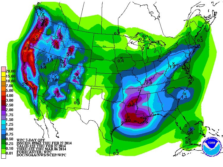
If we do see upwards of 1.5 inches across parts of eastern Oklahoma, then we
can possibly start erasing more of that yellow. From that graphic, however, it
would appear the colors across the rest of the state will be sticking around.
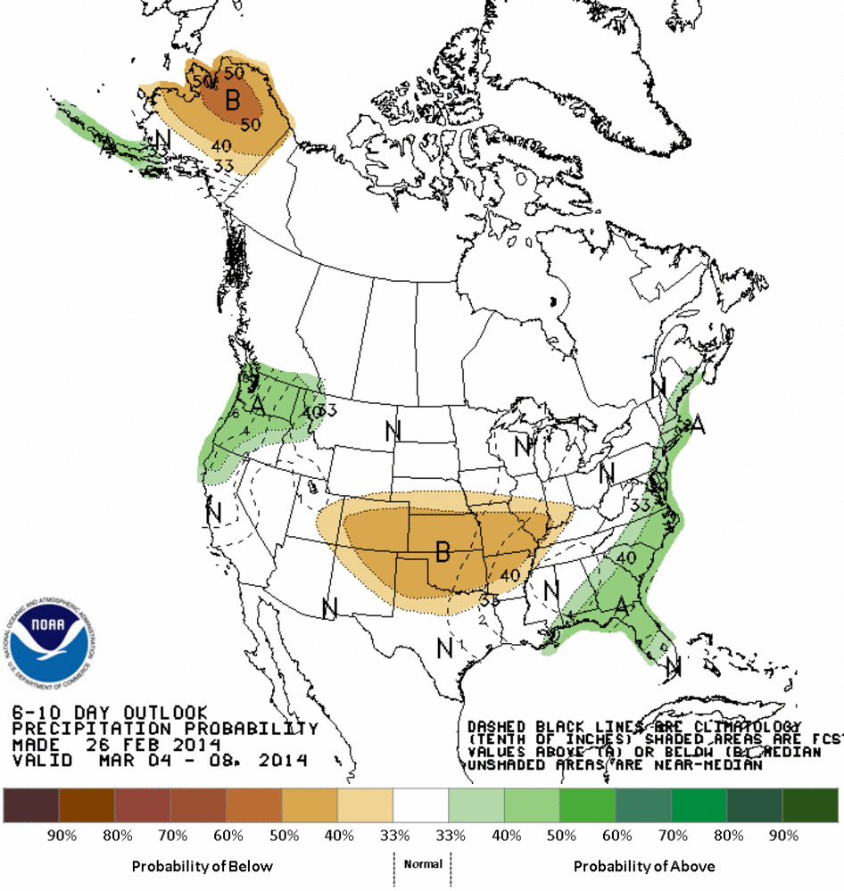
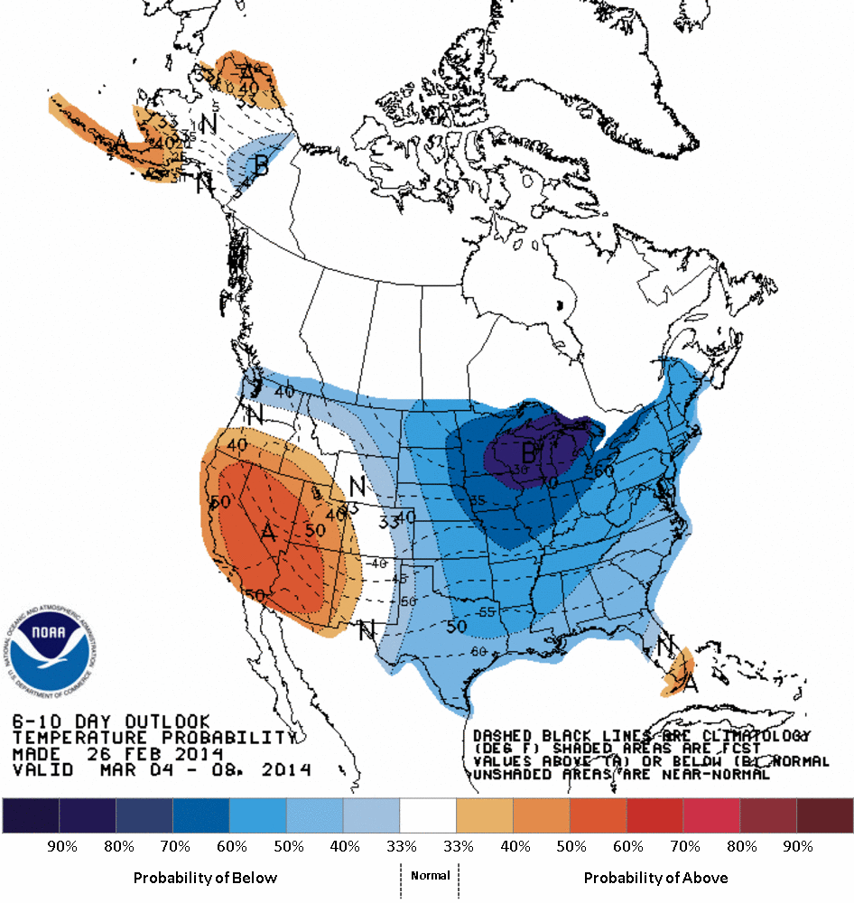
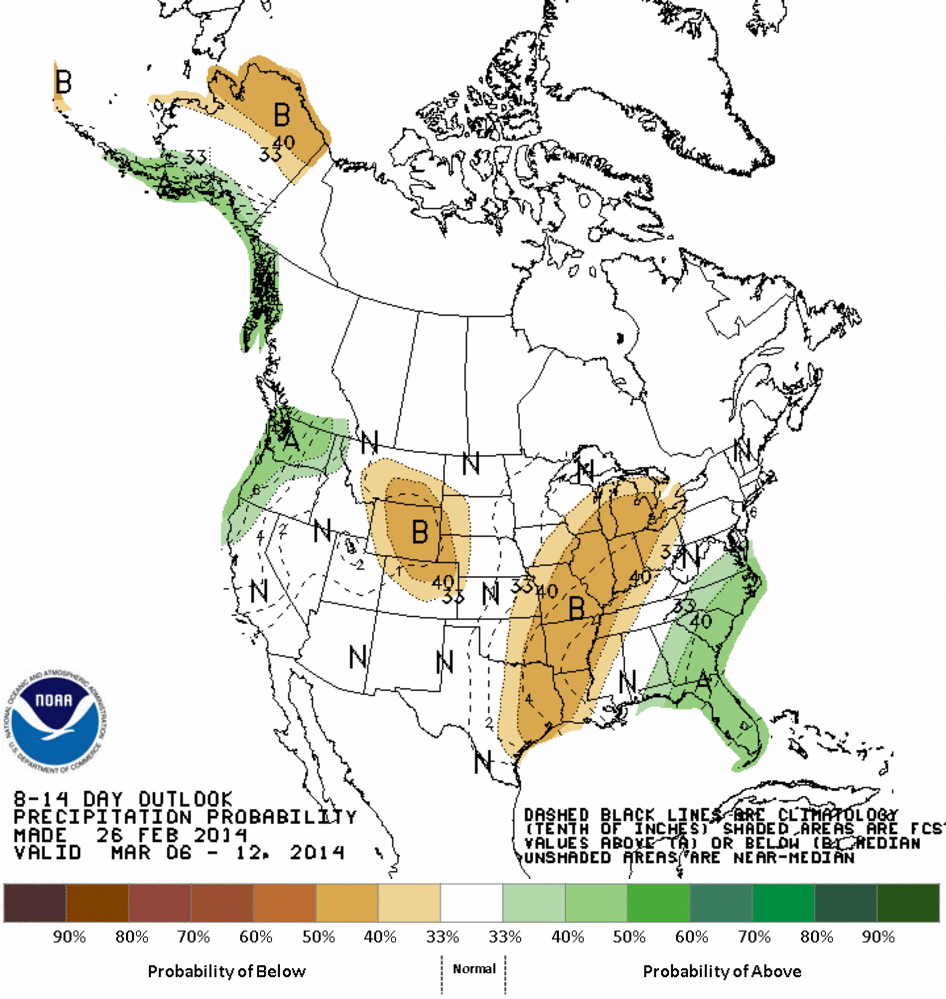
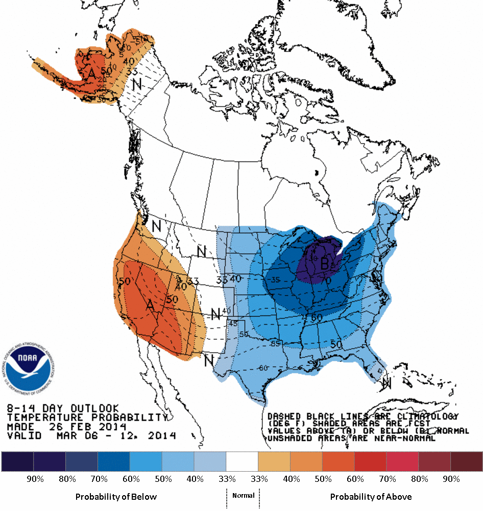
A bit farther out, the CPC 6-10 day and 8-14 day outlooks show increased odds
of dry-to-normal precipitation and colder than normal temperatures from the
March 4 through March 12 period.
CPC 6-10 Day Outlooks
CPC 8-14 Day Outlooks
We'll know more about what CPC sees for all of March with the release of their
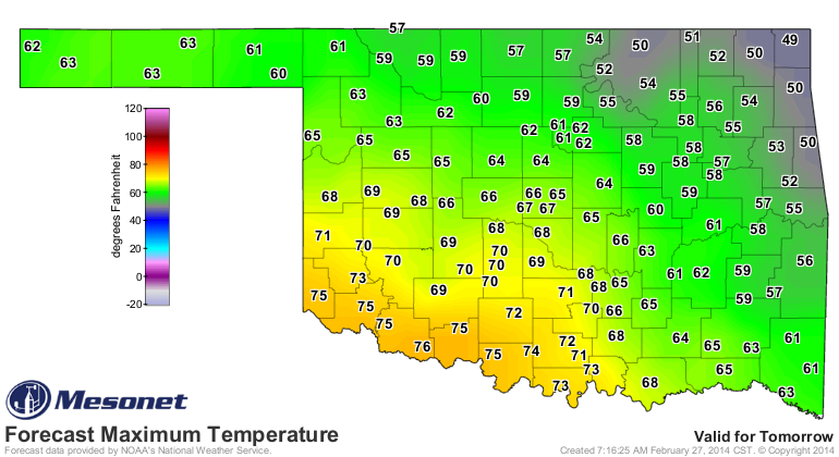
monthly outlooks tomorrow. For now, enjoy your last day of February! Might be
the only nice day for awhile.
Gary McManus
State Climatologist
Oklahoma Climatological Survey
(405) 325-2253
gmcmanus@mesonet.org
February 27 in Mesonet History
| Record | Value | Station | Year |
|---|---|---|---|
| Maximum Temperature | 90°F | WALT | 2011 |
| Minimum Temperature | 4°F | BEAV | 2002 |
| Maximum Rainfall | 1.82″ | CLOU | 2018 |
Mesonet records begin in 1994.
Search by Date
If you're a bit off, don't worry, because just like horseshoes, “almost” counts on the Ticker website!