Ticker for March 6, 2014
MESONET TICKER ... MESONET TICKER ... MESONET TICKER ... MESONET TICKER ...
March 6, 2014 March 6, 2014 March 6, 2014 March 6, 2014
El Nino to the rescue??
"I AM EL NINO! ALL OTHER TROPICAL STORMS MUST BOW BEFORE EL NINO!!!"
Well, Chris Farley had it partly right. El Nino is not a tropical storm, of course,
but it is of tropical origin. This warming of the waters off the west coast of
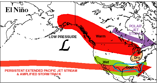
South America tends to bring the southern tier of the U.S. (including Oklahoma)
wetter and cooler weather, mainly during the cool season (as seen in this very
simplified map).
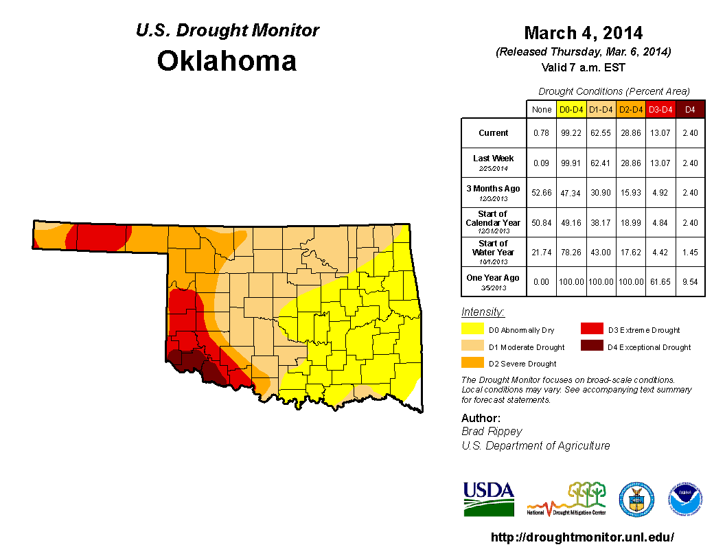
With drought holding strong over western Oklahoma (for 3.5 years, unfortunately)
and continuing to creep east over the rest of the state (only a bit of moisture
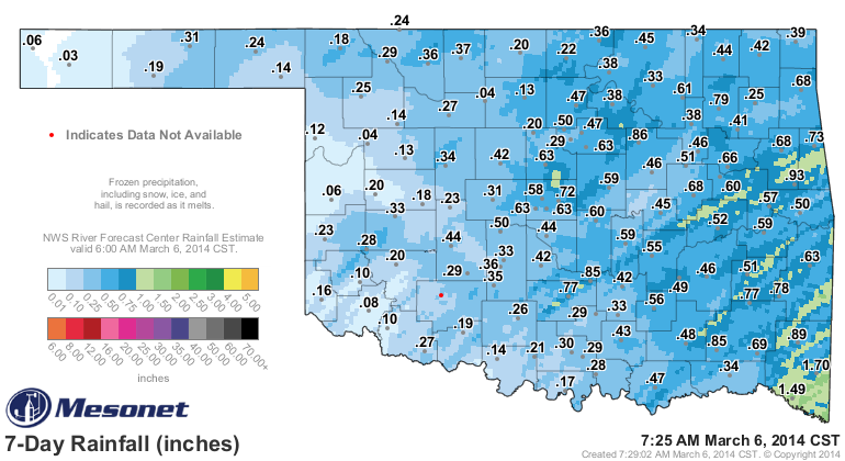
here and there held it back this week ... check out this morning's DM map and
the moisture tally from our latest couple of storms)
a good dose of El Nino and its wetter and cooler (although the cool signal is
stronger for folks south of here) weather would be a welcome change. Provided
that the El Nino produces impacts like it "normally" does. They aren't
foolproof, of course. I'll show you some maps in a minute on how they impact
our area, on average.
So here's some good news! The National Weather service's Climate Prediction
Center (CPC) has issued an "El Nino Watch" signifying at least a 50% chance
of seeing an El Nino develop down in the equatorial pacific. Here is the
pertinent information from CPC's monthly ENSO (El Nino/Southern Oscillation)
discussion, fresh off the presses:
"While all models predict warming in the tropical Pacific, there is
considerable uncertainty as to whether El Ni?o will develop during
the summer or fall. If westerly winds continue to emerge in the western
equatorial Pacific, the development of El Ni?o would become more likely.
However, the lower forecast skill during the spring and overall
propensity for cooler conditions over the last decade still justify
significant probabilities for ENSO-neutral. The consensus forecast is
for ENSO-neutral to continue through the Northern Hemisphere spring
2014, with about a 50% chance of El Ni?o developing during the summer
or fall."
You can view the entire document for yourself righ'chere!
http://www.cpc.ncep.noaa.gov/products/analysis_monitoring/enso_advisory/ensodisc.html
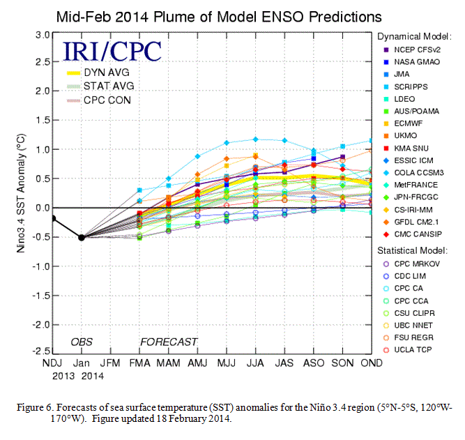
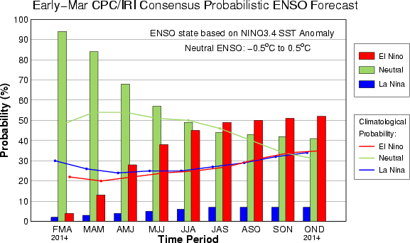
And here you can see the spread of the model predictions and also the odds via
a bar graph. For the modeled output, you're looking for those anomalies to
reach into the +0.5C area, which signifies El Nino (-0.5C is La Nina territory
... everything in between would be considered ENSO Neutral conditions, which
we've been in for the last two winters).
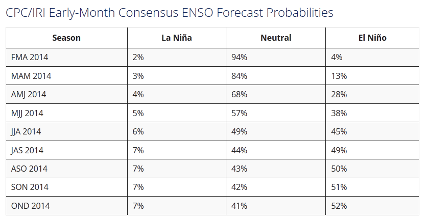
If you're thoroughly confused, this table might be the easiest way to show you.
You can see that by the JAS (July-September) time frame, the probability for
El Nino finally overtakes the odds for Neutral conditions and even pulls away
through the OND (October-December) season. The best news is that the odds of
La Nina are nearly non-existent.
Okay, that's the good news. The bad news is that *normally* (there's that word
again!), our area won't feel the impacts until we get into late fall, through
the winter, and with a little momentum ... into early spring. And all of this
is also dependent upon how strong the El Nino becomes. There's some hint that
a weak El Nino can actually bring drier conditions to the state. But, check
out these maps that show the impact of El Nino on the different seasons.
Officially, they show the risk of extreme wet or dry years. "Extreme" in this
case is defined as being in the highest 20% of the 100 year record. To make
it simple, because I'm confusing myself, just look for the green colors in your
area.
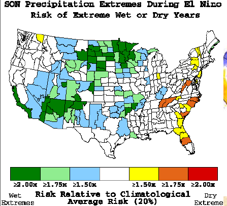
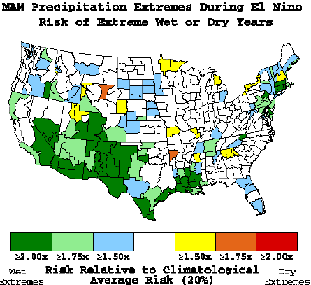
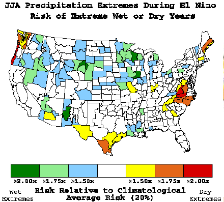
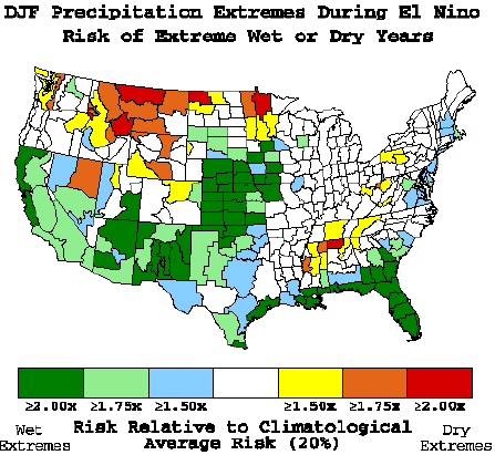
Clearly you can see the odds of having one of those extreme wet seasons is
dominated by the winter months (again, with some bleed-over into late fall and
early spring). I'm showing you those maps because El Nino are famous for ending
droughts, or at least they have been shown to be great helpers in drought
eradication. Given what we've seen across Oklahoma over the last 3.5 years,
especially in western Oklahoma, a little help from a strong El Nino could
be just the miracle we need.
The bad news, of course, is that we have to wait until winter for the best
odds, and we also have to actually get this El Nino to develop! The skill for
predicting the odds of El Nino (or La Nina or Neutral Conditions) is lowest in
the spring, but that skill is not zero. So the issuance of an El Nino Watch is
still significant.
Until then, we'll continue to just look at the week-to-week forecasts, knowing
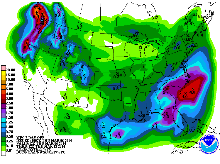
that our rainy season of spring is right around the corner. The 7-day rainfall
forecast looks promising (but not drought-ending).
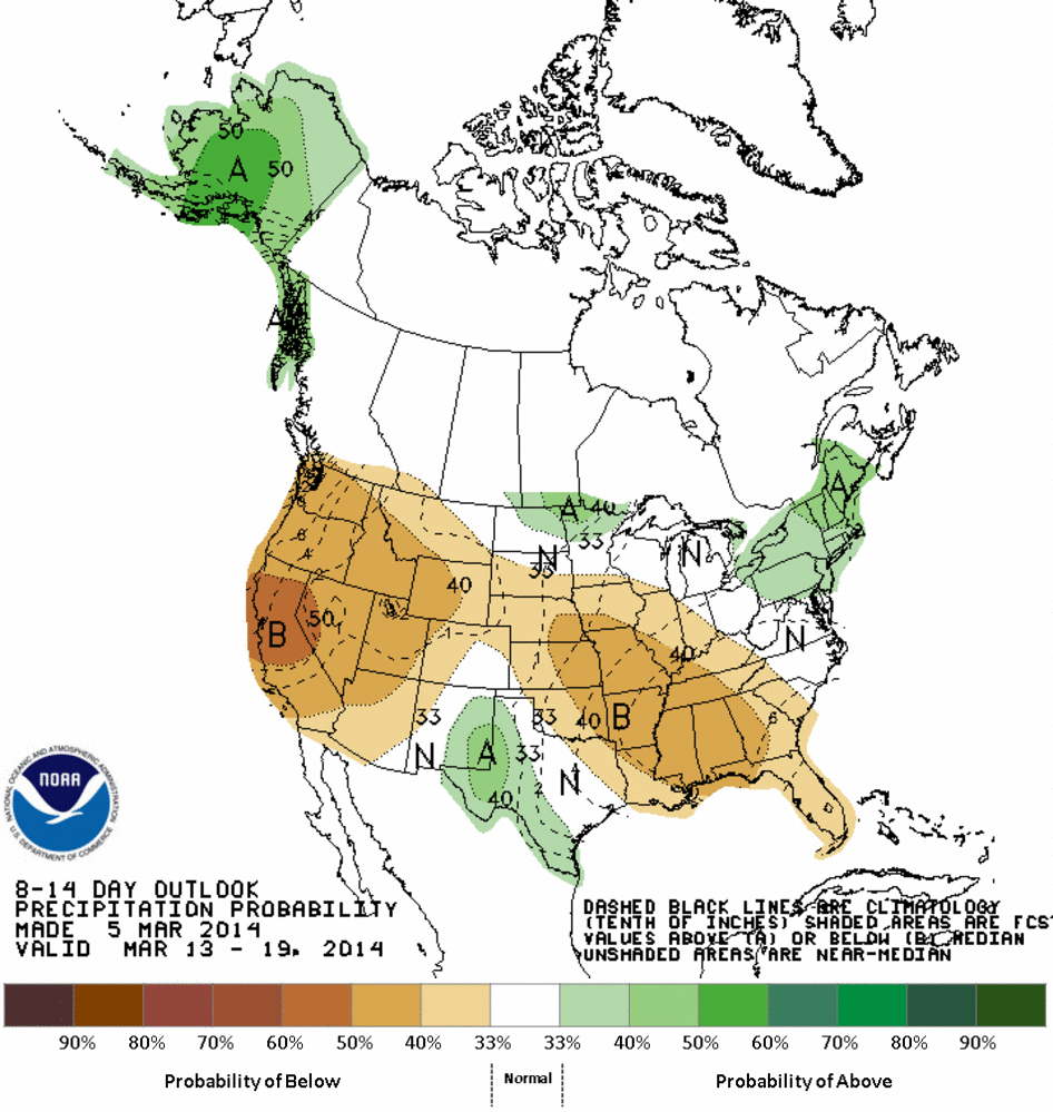
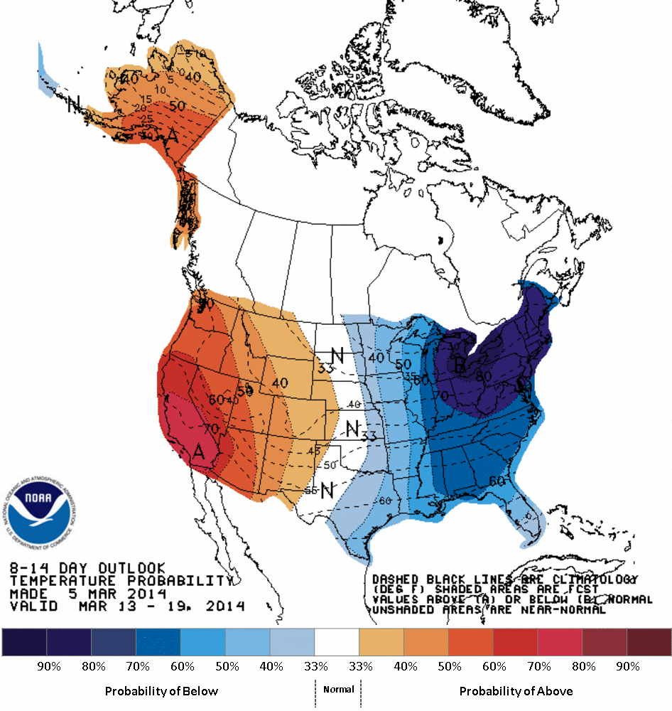
The medium-range CPC outlooks still show us to be in between the trough in the
eastern U.S. and the ridge across the western U.S., so expect us to continue
our see-saw temperature battle, with a bit of whatever moisture we can coax up
from the Gulf before the next front comes through. These cover March 13-19.
Farther out, the Canadian model still gives us pretty low odds of seeing at
least 0.4 inches or so of moisture accumulate in the state through March 20,
at least.
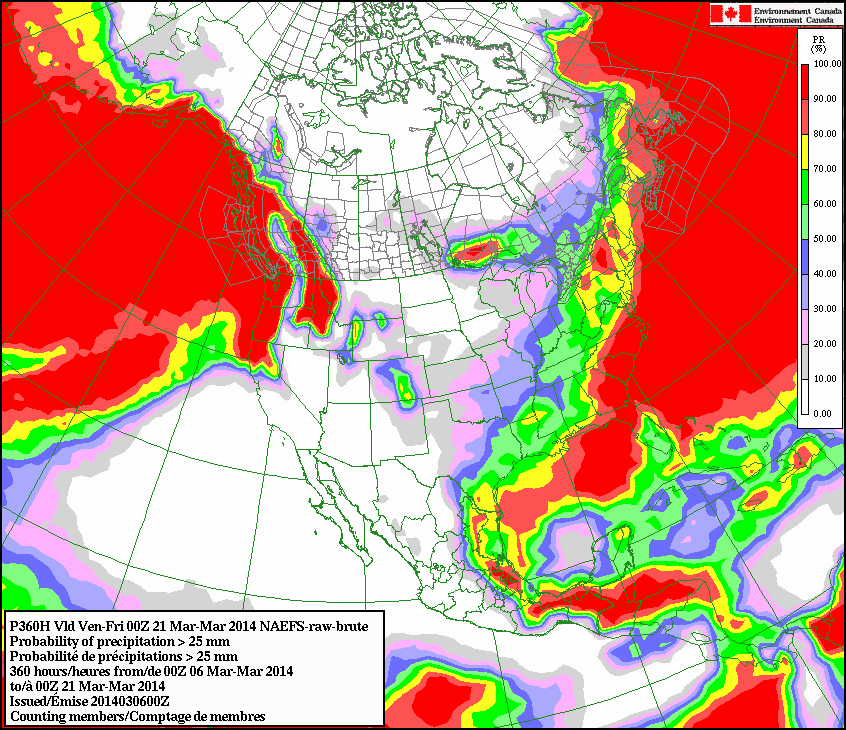
So it does look like we'll tend to be on the dry side for a bit with occasional
bouts of moisture here and there. That can change in a hurry as we warm up and
get back to spring. The next big deluge might be sitting right off the end
of the 7-day forecast as we speak!
Gary McManus
State Climatologist
Oklahoma climatological Survey
Wk: (405) 325-2253
Cell: (405) 823-9054
gmcmanus@mesonet.org
March 6 in Mesonet History
| Record | Value | Station | Year |
|---|---|---|---|
| Maximum Temperature | 87°F | ALV2 | 2017 |
| Minimum Temperature | 9°F | KENT | 2018 |
| Maximum Rainfall | 2.10 inches | COOK | 1995 |
Mesonet records begin in 1994.
Search by Date
If you're a bit off, don't worry, because just like horseshoes, “almost” counts on the Ticker website!