Ticker for February 12, 2014
MESONET TICKER ... MESONET TICKER ... MESONET TICKER ... MESONET TICKER ...
February 12, 2014 February 12, 2014 February 12, 2014 February 12, 2014
GO HINTON GO!
Are you like me (so sorry, there are professionals that can help) and think, if
you're gonna be cold, hot, wet, dry, etc., you might as well break some records?
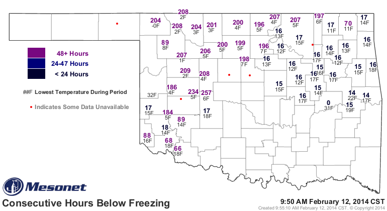
Well, Hinton is giving it a heckuva run at the all-time longest Mesonet streak of
hours below freezing (NOT BELOW ZERO, as I said yesterday at one point). They are
currently at 257 hours. In fact, much of northwestern Oklahoma is above 200 hours
thanks to snow cover (same thing at Hinton). Remember, Vinita and Miami hold the
top two spots in the all-time consecutive hours below freezing record for the
Mesonet (temperature data goes back to 1997) at 282.3 and 260.6 hours,
respectively.
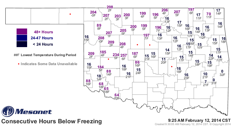
I don't think Hinton is going to make it to 261 to best Miami, but it might be
close. They're already at 29 degrees as I type this
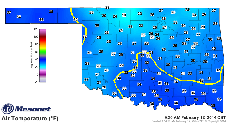
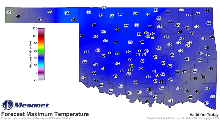
and headed for 40 or so.
But, we have the 4 or 5 bouts of snow to thank for these extended bouts below
freezing. Northwestern and southern Oklahoma got quite a shot of snow yesterday.
Some parts of the NW reportedly had as much as 8 inches of the national
white stuff. Altogether, from very preliminary reports that are in databases I
can reach, it looks like Alva has won the February snow totals so far with 13.7
inches, which is none too shabby for a place mired in drought. Here are the top
10 totals I can spot, including station type, for the Feb. 1-12 period. Again,
very preliminary and data will continue to pour in even after the month is over.
-***-
Station Station Type Total Snowfall (inches)
ALVA 1 COOP 13.7
BRAMAN COOP 12.9
HENNEPIN COOP 12.0
LAVERNE COOP 10.5
HELENA COOP 9.3
LAHOMA RSCH STN COOP 9.0
CHEROKEE COOP 8.5
BEAVER COOP 8.0
EUFAULA CoCoRaHS 8.0
LAWTON COOP 7.6
-****-
For the season (let's go back to Nov. 1, 2013, through today), we have some
other hefty totals as well.
-***-
Station Station Type Total Snowfall (inches)
ROOSEVELT COOP 28.0
FORGAN CoCoRaHS 19.5
ALVA COOP 19.2
BEAVER COOP 19.0
HOBART COOP 18.2
MANGUM COOP 18.0
EUFAULA CoCoRaHS 17.0
MANGUM CoCoRaHS 16.5
WESTVILLE CoCoRaHS 16.3
HELENA COOP 16.2
HENNEPIN COOP 16.2
-****-
Not bad, Roosevelt, for a little town in Kiowa County! Altus Dam had 15 inches
as well.
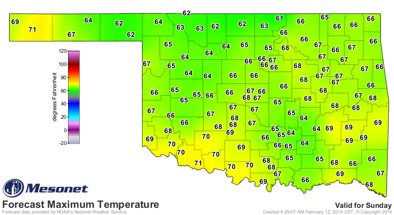
Now we look forward to some heat. Heck, even the 40s today will seem hot, now
that we're acclimated to Siberia. Saturday and Sunday will see lots of 60s, and
even some 70s. Here's what Sunday looks like now.
How long will it last? Well, looks like through much of the rest of February,
if you go by the CPC 8-14 day outlook.
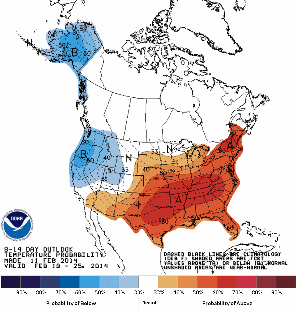
However, see that area of increased odds of below normal temperatures out across
the west coast? That's not a sign of that big ridge remaining there, which
brought us warm air from time to time in January (and horrible drought and
unhelpful heat across the west coast for much of the fall and winter). So this
might just be a lull with a return to winter later.
Something to think about.
Our consecutive hours below freezing map starting to get a lot more sparse.
BRING ON THE HEAT!
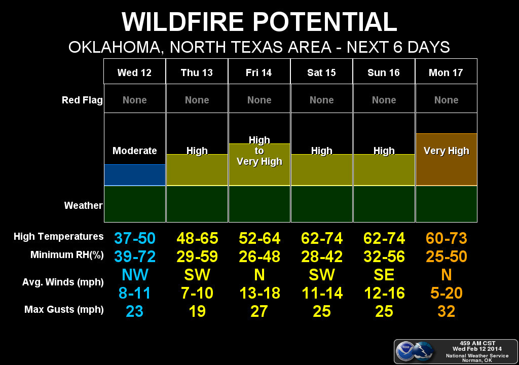
Unfortunately, here comes the fire danger as well.
Gary McManus
State Climatologist
Oklahoma Climatological Survey
(405) 325-2253
gmcmanus@mesonet.org
February 12 in Mesonet History
| Record | Value | Station | Year |
|---|---|---|---|
| Maximum Temperature | 76°F | CAMA | 2023 |
| Minimum Temperature | -3°F | EVAX | 2025 |
| Maximum Rainfall | 1.81″ | BROK | 2020 |
Mesonet records begin in 1994.
Search by Date
If you're a bit off, don't worry, because just like horseshoes, “almost” counts on the Ticker website!