Ticker for October 1, 2013
MESONET TICKER ... MESONET TICKER ... MESONET TICKER ... MESONET TICKER ...
October 1, 2013 October 1, 2013 October 1, 2013 October 1, 2013
September, joys and sorrows
This is the part of the sermon (Ticker) in a small town church where the
preacher (yeah, I won't even pretend ... but, the Ticker Staff) asks for the
joys and sorrows. Joys: we're not shut down! Sorrows: the weather isn't either.
It marches on and on, and so do the summaries. Here's the one for September.
---------------------------------------------------------------------------------
Autumn returned to Oklahoma nearly right on cue during the last week of September
thanks to a moisture-laden cold front. The temperatures got downright chilly with
lows in the 40s and 50s and highs in the 60s and 70s for a couple of days,
although temperatures zoomed back into the 80s on the month's final day. The cold
front provided a brief respite to what had become, at least for most of the state,
a decidedly dry and warm September. The late heroics by Mother Nature were not
enough to avoid the inevitable, however, as the month finished both drier and
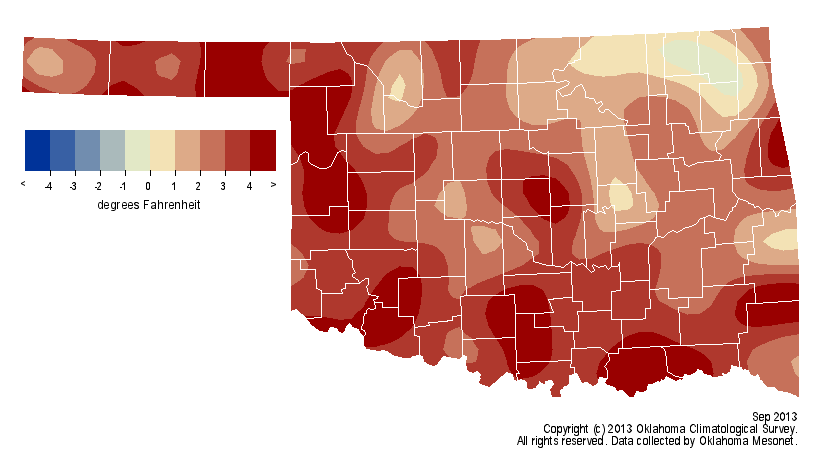
warmer than normal. According to preliminary data from the Oklahoma Mesonet, the
statewide average temperature was 75.4 degrees, 3 degrees above normal and the
22nd warmest September since records began in 1895.
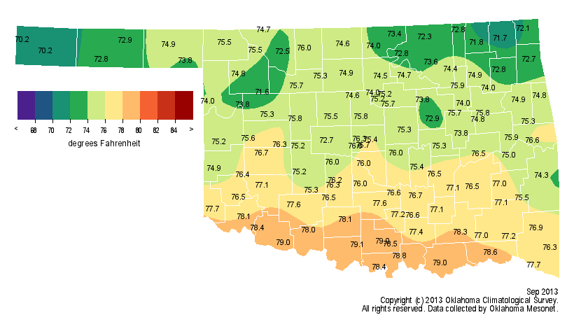
The month's highest temperature, 108 degrees, occurred at Waurika on the first
day of the month. Kenton was the winner of the lowest temperature contest with
a reading of 39 degrees on the 28th. The last triple-digit temperatures of
September, and almost certainly for the year, occurred at several locations on
the eighth.
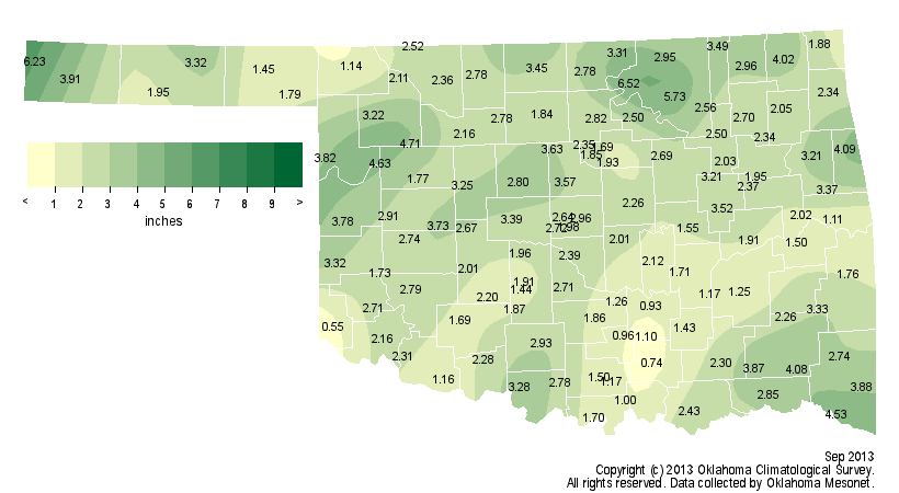
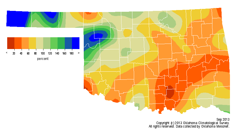
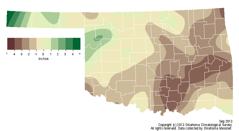
The rainfall was a bit trickier since the totals were quite variable across the
state. Nevertheless, the statewide average total was 2.60 inches, 1.21 inches
below normal and the 51st driest September on record. Kenton, normally one of
the driest stations in the state, nearly led all Mesonet sites with a whopping
6.2 inches of rainfall, but was eventually bested by Burbank's 6.5 inches.
Those two generous totals stand in stark contrast to the fortunes of most of
southern Oklahoma. The Mesonet site at Tishomingo had a September total of 0.74
inches, and Hollis in the far southwest came in with the state's lowest total
of 0.55 inches. The Panhandle region was the big winner with their 13th wettest
September on record at more than an inch above normal. South central Oklahoma
had an average total of 1.71 inches, 2.63 inches below normal to rank as the
27th driest for that area.
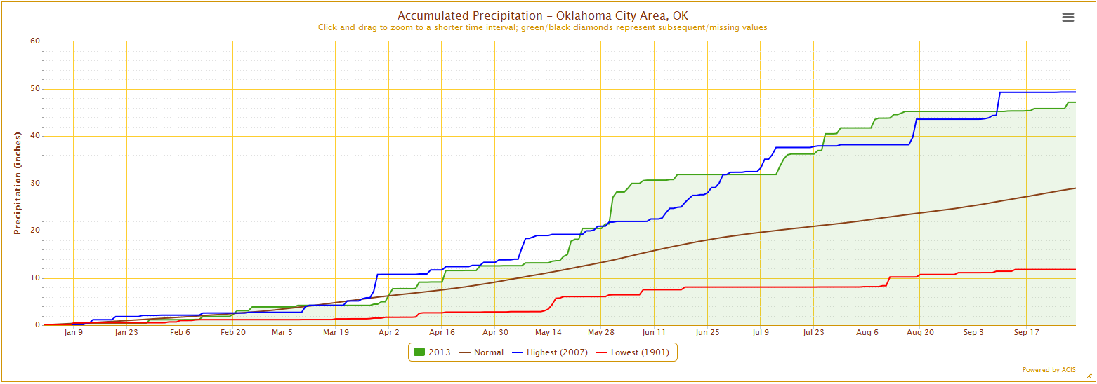
Oklahoma City, which had been on pace to break their annual rainfall total,
finally came back to earth with a total of 1.95 inches. That falls well below
their normal September total of 4.06 inches. Their January-September total of
47.13 inches is still the second highest total on record for that period,
trailing 2007's 49.27 inches. Oklahoma City's normal annual precipitation total
is 36.52 inches.
Tulsa has experienced differing fortunes during 2013, unfortunately. Their
September total of 1.25 inches was 2.04 inches below normal and brought their
January-September total to 25.88 inches, their 35th driest such period on
record and nearly 6 inches below normal. Tulsa's normal annual total is 40.93
inches.
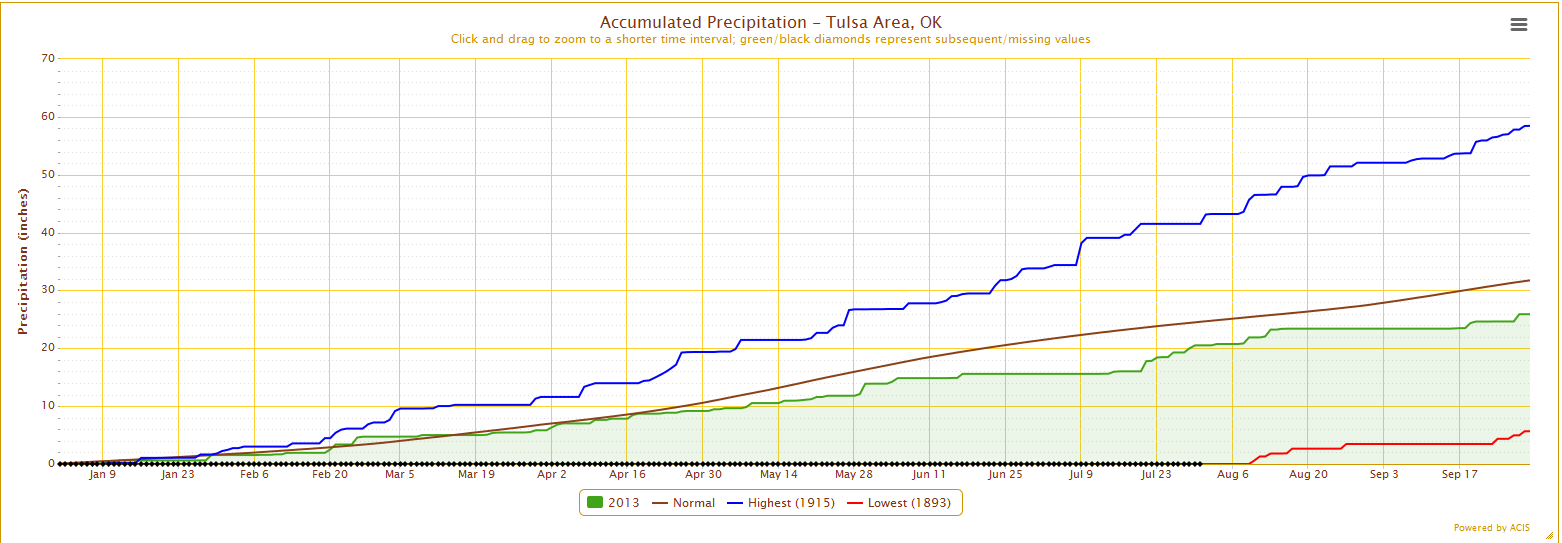
Records for Oklahoma City and Tulsa date back to 1891 and 1894, respectively.
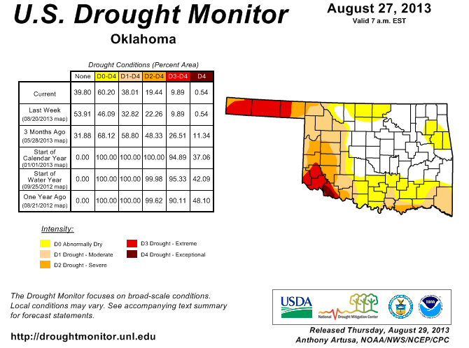
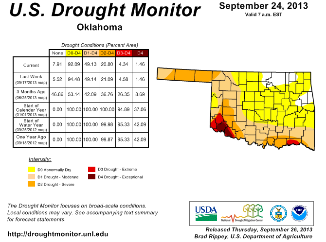
The widespread rains late in the month helped improve drought conditions that
had been creeping throughout the state since mid-August. The U.S. Drought
Monitor had gone from 38 percent of the state in drought at the end of August
to 49 percent on the final September map. The southwest continued to be the
hardest hit area with Jackson and Tillman counties covered by the "exceptional"
drought, the worst category on the Drought Monitor intensity scale. The
late-month moisture will be reflected on the first October Drought Monitor map.
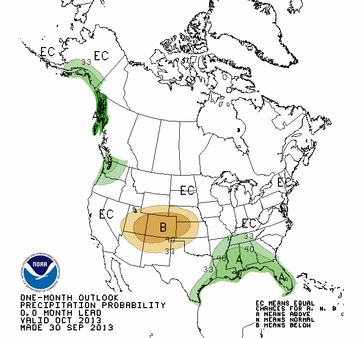
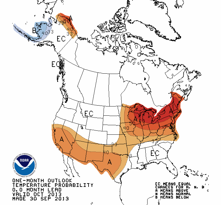
The October outlooks from the National Weather Service's Climate Prediction
Center (CPC) call for increased chances of above normal temperatures for the
entire state, and below normal precipitation across northwestern Oklahoma.
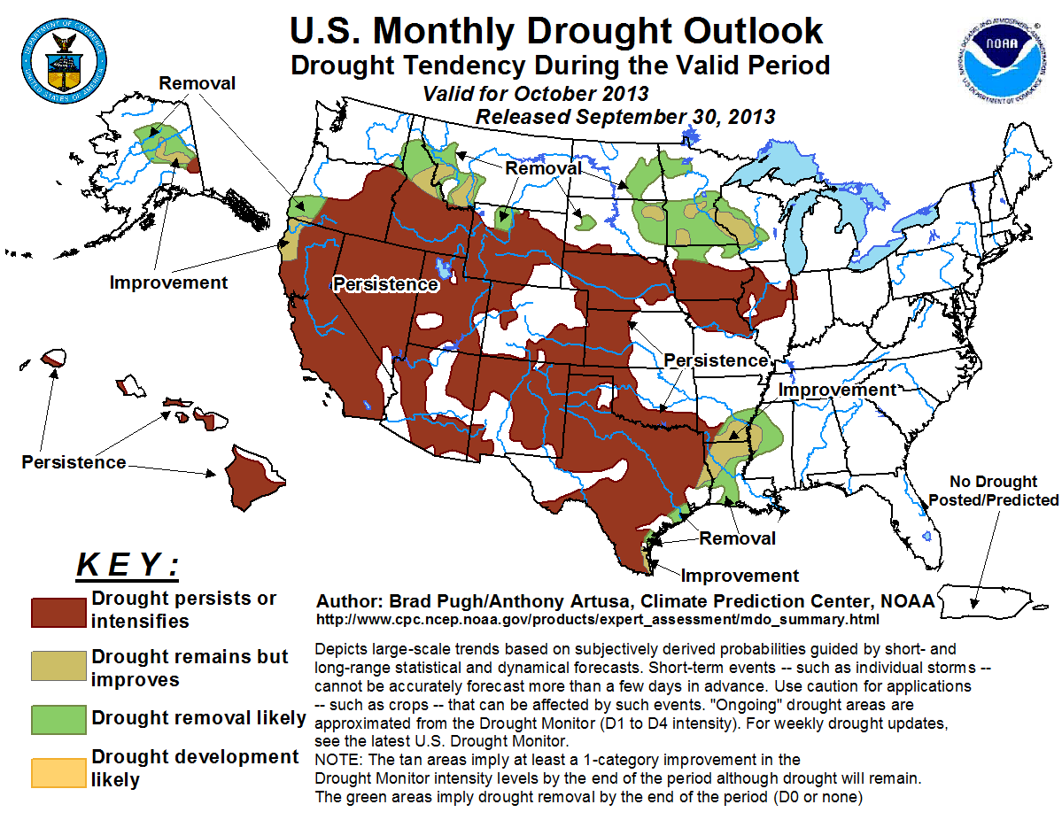
Accordingly, that led CPC to issue a drought outlook for October that sees
drought persisting across those areas where it currently exists, but no
intensification across the rest of the state.
Gary McManus
Associate State Climatologist
Oklahoma Climatological Survey
(405) 325-2253
gmcmanus@mesonet.org
October 1 in Mesonet History
| Record | Value | Station | Year |
|---|---|---|---|
| Maximum Temperature | 99°F | SLAP | 2000 |
| Minimum Temperature | 34°F | KENT | 2009 |
| Maximum Rainfall | 3.52″ | ERIC | 1998 |
Mesonet records begin in 1994.
Search by Date
If you're a bit off, don't worry, because just like horseshoes, “almost” counts on the Ticker website!