Ticker for September 26, 2013
MESONET TICKER ... MESONET TICKER ... MESONET TICKER ... MESONET TICKER ...
September 26, 2013 September 26, 2013 September 26, 2013 September 26, 2013
And Kenton shall lead the way?
Okay, I know Buffalo is the #1 top garden spot in the universe, but if there was
a close second (and there ain't) ... it would be Kenton, home of Black Mesa, Lake
Etling and the good old dinosaur tracks. But for September 2013, it also looks
likely that it will end up as the wettest spot in the state. Check out the maps
for September thus far.
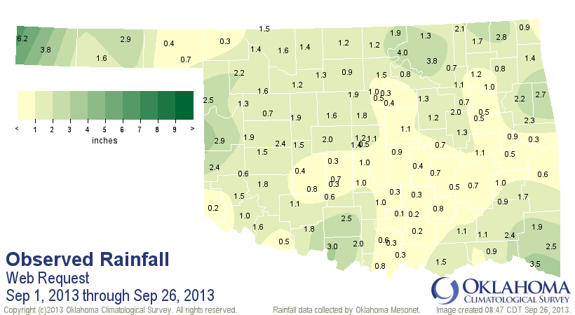
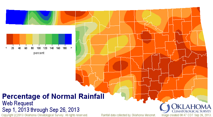
How unusual is Kenton's 6.2 inches, as measured by the Mesonet? Well, their
normal moisture total for September is 1.4 inches (for those missing all their
fingers and toes, that's 4.8 inches above normal). That would also become Kenton's
second wettest September on record, dating back to 1901, behind 1941's 9.81
inches.
Now, how unusual is it for Kenton to lead all the Mesonet sites in precipitation
for a month? I assumed it had never happened before (Mesonet data begins in
1994), but crackerjack Mesonet computerizing guru Nathan Bain had to go and
spoil my statistics by showing that Kenton has actually led the state twice
before: August 2006 and August 2010. Wow, that wasn't that long ago!
Climatologically speaking, you would expect one of the summer months to be
Kenton's sweet spot. Their placement near the lee of the Rockies allows them to
get caught up in the Desert Southwest's monsoon flow from time to time.
TRIVIA TIME: What Mesonet station has won the monthly race for moisture the
most (out of 236 total months)?
WRONG! Unless you said Mt. Herman, way down yonder in McCurtain County. Our
station at Cloudy came in a close second with 12, and Idabel placed third with
9. No shocker there.
Now the only thing that can ruin all this fun I just wrote about is the front
approaching the state. Once it moves in this weekend, a bit of rain here and
there could boost somebody ahead of Kenton.
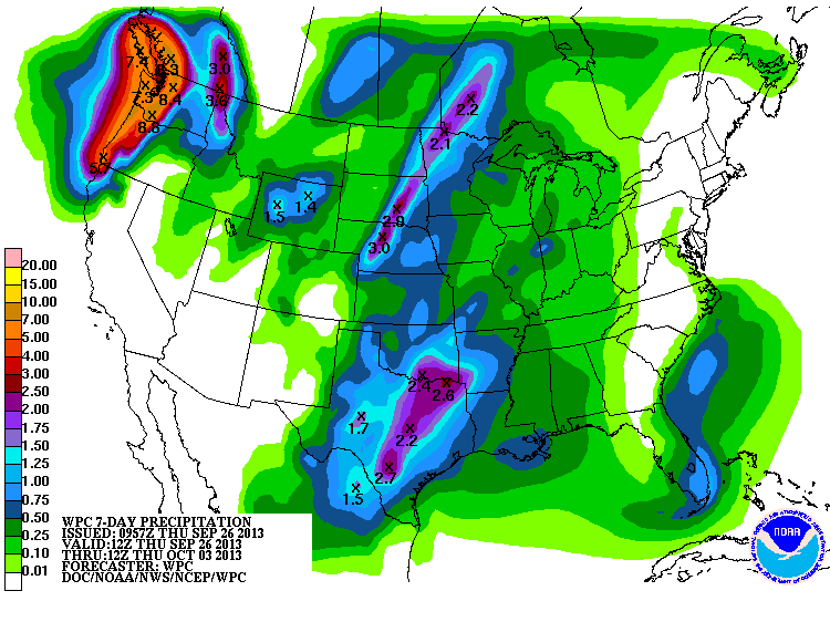
However, even if that 2.4 bullseye hits in the southeast, it won't be enough to
boost them above 6 inches, since they're sitting at 1-3 inches right now. Maybe
up in Osage County, where Burbank is at 4.0 inches already. At least it's
something to look for as the much-needed rain falls.
Ohhhhh yeah, they did release a Drought Monitor map this morning as well. The
rains of last week did help to forestall any further drought development, and
also even relaxed it in a bit of the state.
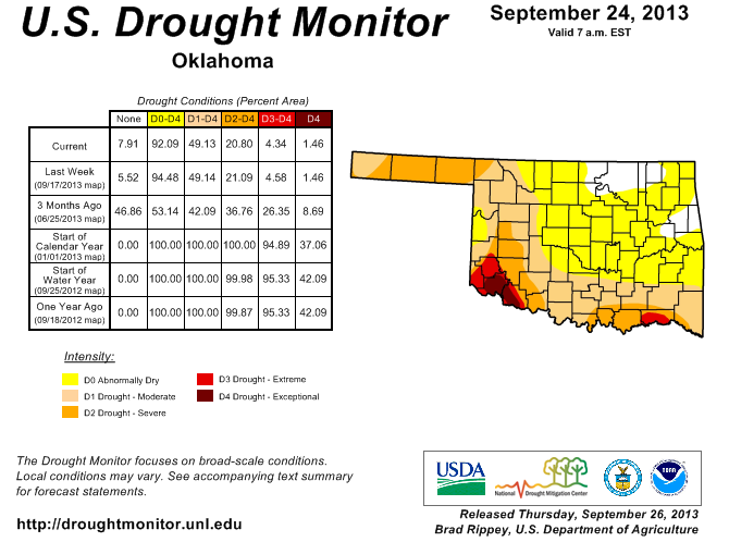
We're hoping this weekend's rain will help us do the same for next week, because
looking back to the first of August, the last two months have been downright
nasty in southern Oklahoma (looks like Kenton leads that period as well).
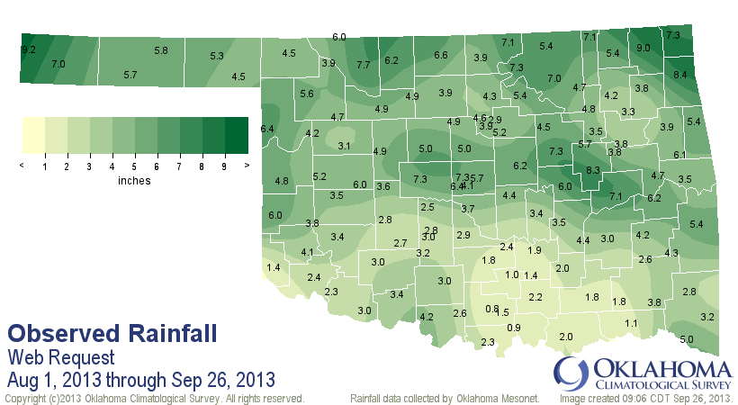
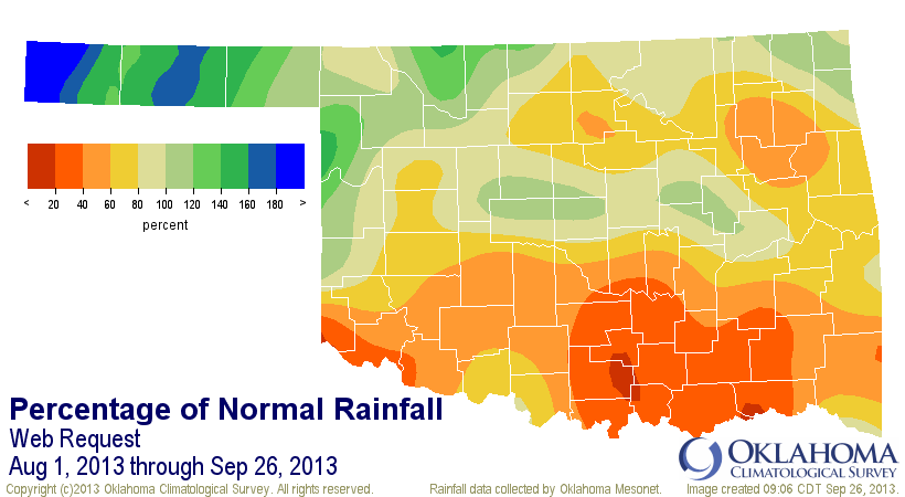
Very, very nasty indeed. Statewide, the average total over that period was 4.46",
1.59" below normal, 23rd driest such period since 1921. Obviously worse than
that down across the southern half of the state. We are very close to pulling
the trigger on drought intensification in that area.
So go rain! Go team! Go Kenton!
Oh yeah, know who has never led the state in precipitation since the Mesonet
began in 1994? Buffalo. What a crime!
Gary McManus
Associate State Climatologist
Oklahoma Climatological Survey
(405) 325-2253
gmcmanus@mesonet.org
September 26 in Mesonet History
| Record | Value | Station | Year |
|---|---|---|---|
| Maximum Temperature | 101°F | SLAP | 2020 |
| Minimum Temperature | 29°F | CAMA | 2000 |
| Maximum Rainfall | 7.70″ | WEST | 1996 |
Mesonet records begin in 1994.
Search by Date
If you're a bit off, don't worry, because just like horseshoes, “almost” counts on the Ticker website!