Ticker for August 15, 2013
MESONET TICKER ... MESONET TICKER ... MESONET TICKER ... MESONET TICKER ...
August 15, 2013 August 15, 2013 August 15, 2013 August 15, 2013
The incredible shrinking drought
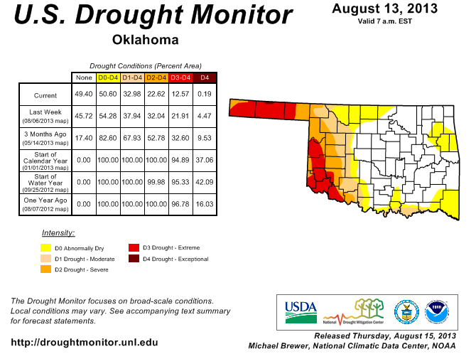
Need I say more? Probably not, but since when has that ever stopped me? According
to this morning's release of the U.S. Drought Monitor, 67% of the state is now
drought free (no D1-D4) and 49% of the state is without even the D0-Abormally Dry
monicker. That state has not been in that good of shape since June 5, 2012.
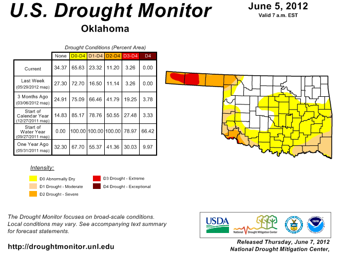
But there are still differences between that time, because all of the momentum
at that time back in 2012 was towards developing drought. The current situation
is completely the opposite, with drought on the run across the entire state. So
even though only 11% of the state was in D2-D3 (Severe-Extreme) drought 14
months ago, our current percentage of 23% has a different connotation. Wanna know
how? Me too. Be back in a second.
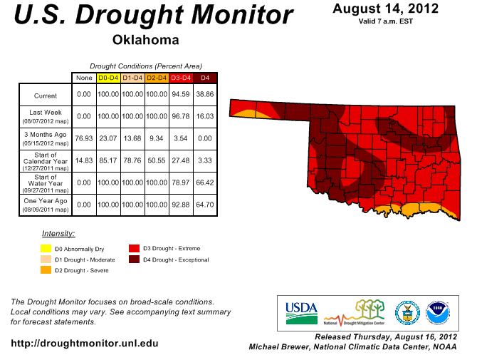
Uh huh, just as I thought. Last year at this time, some two months later than the
June 5 map, the state was 100% covered in drought, including 39% in the D4-
Exceptional category.
Now normally I try and write the Ticker in terms everybody can understand, but
I'm going to go really technical on you with an abstract and quite complicated
scientific concept that only the most trained climatological minds have been
able to grasp ... so bear with me:
More rain generally means less drought.
Okay, did I lose you there? But yes, we have the rains from the last month or
so from our accelerated loss of drought. We started with a nice February through
mid-June period (save for the tornadoes and large hail and whatnot), survived
a dry mid-June through mid-July that saw drought on the rise once again, and
found salvation in uncharacteristically wet mid-July through mid-August
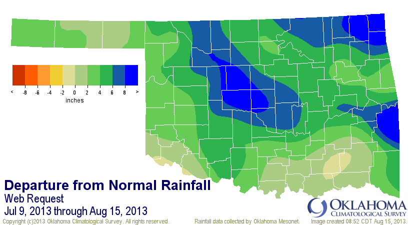
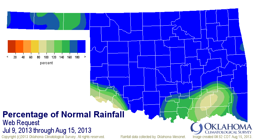
conditions. We've covered the earlier periods a lot, but here's a look at what
we've seen since July 9, the day the summer rains returned.
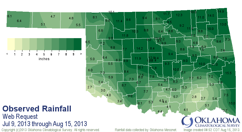
Here are the climate division statistics with historical rankings back to 1921
for each division and also the statewide marks.
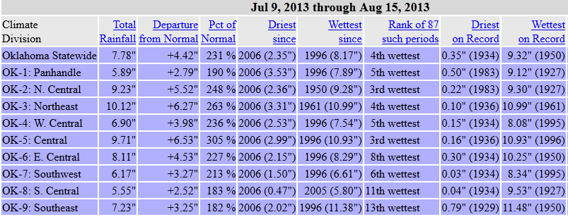
The climate division statistics show that on a larger scale basis, different
areas of the state have been from 2-7 inches above normal. The departure map
from above shows that there are localized areas from 8-12 inches above normal
since July 9.
In fact, it has rained somewhere in the state every single day since July 13,
and only a lack of rain anywhere on July 12 stopped that streak from going back
to July 9 (hence, the reason I keep starting with July 9). But it's not just
the rain that has helped the state with the drought. An important by-product of
summer-time rains has also given it's aid to the drought blasting ... the cooler
than normal weather. According to statistics from the Oklahoma Mesonet, the
statewide average for August thus far was 80.9 degrees, 1 degree below normal.
However, the important statistic lies within that average, which takes the
average of the maximum and minimum temperatures. The statewide average high
temperature has been 3 degrees below normal and the normal low was a degree
ABOVE normal. So we've been missing on those desiccating 100s for most of the
month. Compare that to last year's hellish first couple of weeks of August.
-***-
Avg. High Avg. Low Avg. Mean
Aug. 1-14, 2012 101.2 71.4 86.3
Aug. 1-14, 2013 91.2 70.6 80.9
-****-
So a 10-degree difference in the average high temperatures.
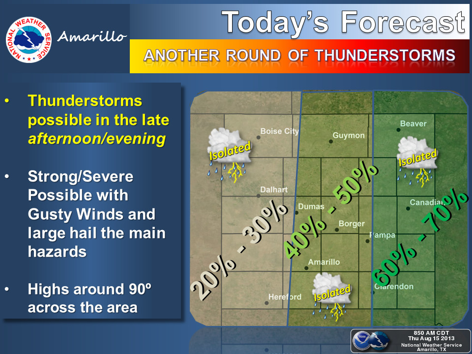
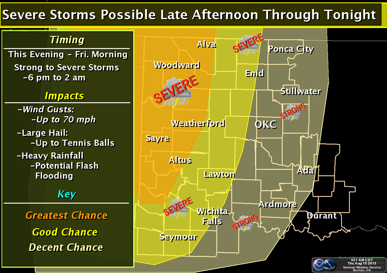
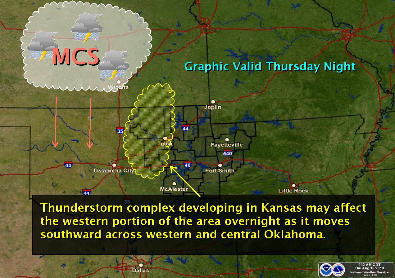
The good news if the rain is not over yet, because there is still drought to
be smashed out there. Maybe another half-inch to an inch across western Oklahoma.
The hope is, of course, that more rain will fall across southwestern Oklahoma,
the hardest hit area of the state currently.
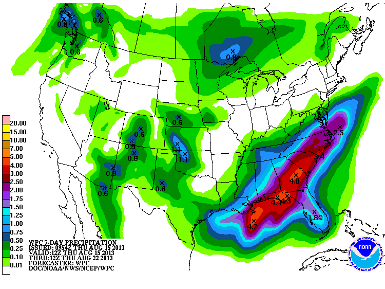
Unfortunately, that might come with some of the rough stuff, as shown by our
friends at our local NWS offices.
That's okay. We can take the good with the bad. That's the Facts of Life,
remember?
"You take the good, you take the bad,
you take them both and there you have
The Facts of Life, the Facts of Life."
Okay, I'm not even going to tell you youngsters to google it. Just trust me
when I tell you that Mrs. Garrett was the most annoying character on TV since
Dr. Bombay (now THAT one you'll have to google).
That extreme digression is a signal that it's time to go. But if there is one
thing I hope you gleaned from this Ticker, it's the complicated concept that rain
helps ease drought. If there are two thing you gleaned, it's that and a really
bad case of indigestion.
Gary McManus
Associate State Climatologist
Oklahoma Climatological Survey
(405) 325-2253
gmcmanus@ou.edu
August 15 in Mesonet History
| Record | Value | Station | Year |
|---|---|---|---|
| Maximum Temperature | 107°F | GRA2 | 2024 |
| Minimum Temperature | 50°F | EVAX | 2016 |
| Maximum Rainfall | 4.96 inches | WIST | 2018 |
Mesonet records begin in 1994.
Search by Date
If you're a bit off, don't worry, because just like horseshoes, “almost” counts on the Ticker website!