Ticker for July 26, 2013
MESONET TICKER ... MESONET TICKER ... MESONET TICKER ... MESONET TICKER ...
July 26, 2013 July 26, 2013 July 26, 2013 July 26, 2013
Zounds!
Here we sit in the last stages of July talking about widespread flooding across
parts of central Oklahoma, even as heavy rains continue to spread to the east.
Take a gander at the Mesonet rainfall map for the last couple of days (just to
be safe) and you can see how much (and yes, how little) has fallen.
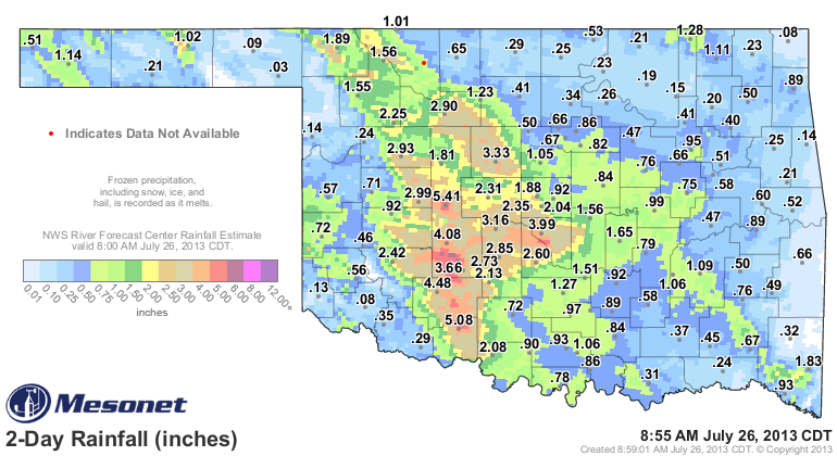
Those widespread 2-4 inch amounts west of I35 actually contain radar estimated
totals of more than 6 inches. That has led to the flash flood warnings issued
by the NWS this morning ... just too much rain in too little of a time period.
That has also led to flood warning as well. Some places have both flash flood
AND flood warnings at the same time! The difference is still important. A flash
flood warning deals with flooding that occurs within 6 hours of intense rainfall.
A flood warning, or areal flood warning, pertains to flooding that will occur
gradually over a longer period of time, and over a larger area. So I guess the
message for some of those counties is that it's flash flooding now, and flooding
will continue over a larger area (in areas prone to such flooding) even after the
rain has subsided.

The rain is pulling away from I-35 farther to the east, so watch for those
totals across eastern Oklahoma start to rise as well.
http://radar.weather.gov/Conus/full_loop.php
Those heavy rains did clip the eastern edge of the extreme drought in western
Oklahoma. Unfortunately, for places like the extreme southwest and most of hte
Panhandle, they'll have to go right on hoping for more rain. Altus, Hollis,
Mangum, Beaver and Slapout all received less than a tenth of an inch thus far.
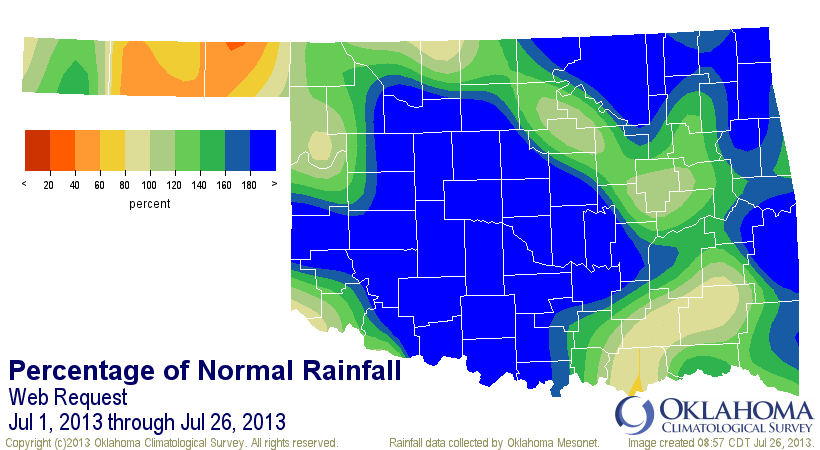
The statewide average for July 1 through this morning is up to 4.1 inches and
still climbing. That already makes this July the 26th wettest on record, at
least according to preliminary data from the Oklahoma Mesonet. It will
continue to zoom up the rankings as eastern Oklahoma gets pounded throughout the
day. At any rate, that July percent of normal map is looking mighty blue now!
Gary McManus
Associate State Climatologist
Oklahoma Climatological Survey
(405) 325-2253
gmcmanus@mesonet.org
July 26 in Mesonet History
| Record | Value | Station | Year |
|---|---|---|---|
| Maximum Temperature | 111°F | HOLL | 2011 |
| Minimum Temperature | 50°F | CAMA | 2004 |
| Maximum Rainfall | 5.09 inches | BROK | 2013 |
Mesonet records begin in 1994.
Search by Date
If you're a bit off, don't worry, because just like horseshoes, “almost” counts on the Ticker website!