Ticker for July 12, 2013
MESONET TICKER ... MESONET TICKER ... MESONET TICKER ... MESONET TICKER ...
July 12, 2013 July 12, 2013 July 12, 2013 July 12, 2013
A Game- (and summer- and drought-) changer??
I've preached and preached about how summer is not exactly the best time to be
looking for drought relief. Of course, it HAS happened before, but it normally
just doesn't rain in the summer very much. So, of course, that almost guaranteed
that we would see drought relief this summer. No, I'm not talking about the
customary "popcorn" style storms we've seen the last couple of days. Those storms
go up with the heat of the day, pretty much stay in one place or even drift
aimlessly, and dump lots of rain in a localized area (congrats to places like
Bessie, Retrop and McCurtain County).
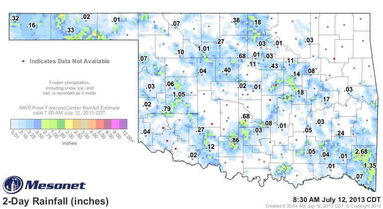
No, I'm talking about a nice, generalized rain over the entire state. Thanks to
an upper-level low headed this way from the east. It has been stalled over the
eastern Ohio Valley, leading to flooding rainfall over in that area.
Here it is now:

and here is where it's forecast to be (by one of the main forecast models) Sunday
night around 7 p.m.:
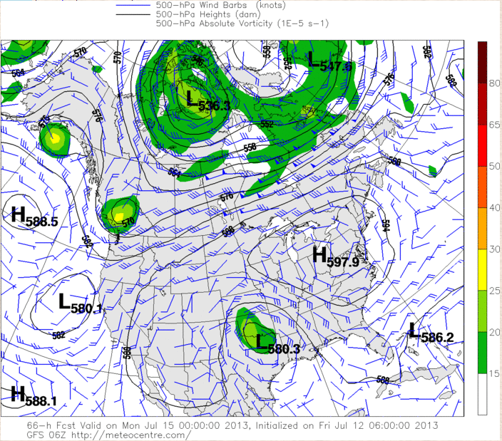
This low would find at least some moisture to work with, and has the potential
to bring a nice rain to a large area, as evidenced by the 7-day rain forecast
from the WPC.
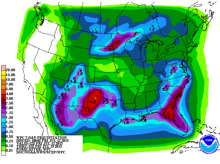
From 1-3 inches across much of western and southern Oklahoma, in July? Are you
kidding me? Can the baldness cure be far behind? Now we do need to slow down
a bit here. Forecasting where an upper-level low goes in the summer is a bit
dicey, so trying to pinpoint exactly where any heavy rains would be is a bit
tough right now. But somebody stands to get some rain. And when it rains in the
summer, it gets cooler, and it can dramatically impact temperatures for some
time afterwards as well (replenish soil moisture, giving the sun something to
do with its energy instead of heating the surface ... as well as greening things
back up so we'll have nice green vegetation absorbing that sunlight).
It would be nice if that low would stick around. They can do that during the
summer, becoming persistent with the storm track (jet stream) pushed far to the
north, leaving little impetus for weather patterns to change quickly in the
southern U.S. But alas, the low appears to wash out and go away after its
visit. But that's okay. We need this. Maybe I'm going overboard, but I'd much
rather be a little overzealous about this than the chances for more drought
intensification.
-------------------------------------------------------------------------------
La Who?
While we're talking about some good news, the latest long-range SST model
forecasts are showing the chances for a La Nina this upcoming fall and winter
are low. Remember, La Nina tends to bring us warmer and drier weather (think
2010-2012), so it is normally NOT our friend. The bad news is an El Nino is not
showing up at this time either. El Nino tends to bring us cooler and wetter
weather. So we will be stuck with the vagaries of ENSO-Neutral conditions.
Maybe not as good as El Nino, but better than the dreaded La Nina. And remember,
that's how it's showing up now. We are well past the spring blind-spot when
forecasting SSTs out for the cool season has extremely low skill.
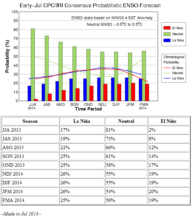
So around the Dec-Feb time frame, we see ENSO-Neutral has a 55% chance of
occurring, while La Nina and El Nino lag behind nearly even at 26% and 19%,
respectively.
We will see how it progresses over the next few months. Remember, this time last
year an El Nino looked probable, started to develop later in the fall, then
fizzled. I suppose the opposite would also be possible. Let's hope it would
be El Nino that developed and not La Nina, however!
One last caveat ... ENSO is not the only driver of global climate patterns and
the associated regional impacts. But, it's a biggie.
Gary McManus
Associate State Good News Bringer For A Change
Oklahoma Climatological Survey
(405) 325-2253
gmcmanus@mesonet.org
July 12 in Mesonet History
| Record | Value | Station | Year |
|---|---|---|---|
| Maximum Temperature | 110°F | HOLL | 2001 |
| Minimum Temperature | 52°F | EVAX | 2021 |
| Maximum Rainfall | 4.44 inches | OKMU | 1996 |
Mesonet records begin in 1994.
Search by Date
If you're a bit off, don't worry, because just like horseshoes, “almost” counts on the Ticker website!