Ticker for July 11, 2013
MESONET TICKER ... MESONET TICKER ... MESONET TICKER ... MESONET TICKER ...
July 11, 2013 July 11, 2013 July 11, 2013 July 11, 2013
Drought on the move
My last few Tickers would have come with the theme from "Jaws" if I knew how to
write something like that as I knew what we were going to see with the newest
U.S. Drought Monitor report. I'm not really allowed to tell you beforehand
the EXACT changes before Thursday (it's one of those "I can tell you, but I'd have
to kill you ... with really bad jokes" type of a deal), but I was trying to give
out hints.
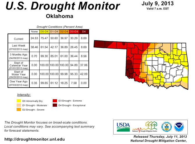
The amount of drought in the state increased from 42% to 51%. That covers the
gamut from Moderate (D1) through Exceptional (D4) drought. And the area covered
by at least Abnormally Dry (D0) through D4 conditions increased from 62% to 75%,
approximately. The holdouts are central Oklahoma through SE Oklahoma, and the far
northeastern corner. The big increases occurred up around Osage County and all
along the Red River from I35 east.
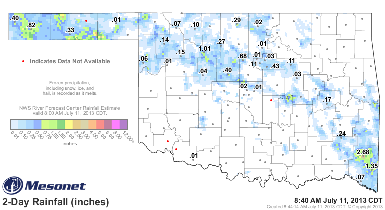
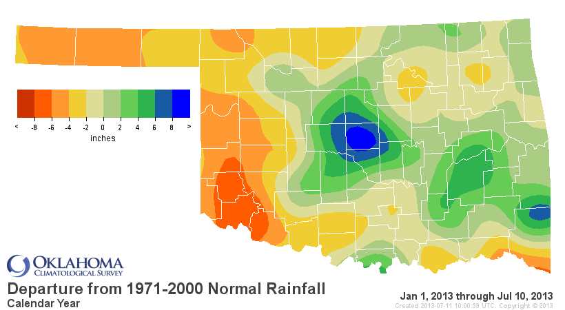
No secret as to why. I've shown the pitiful looking rainfall maps this week
already. We did have some rains over the last few days, but way too spotty to do
much good (other than for those under the storms).
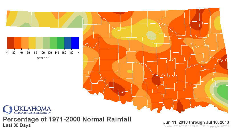
The period since June 10th is the 10th driest since 1921 with a statewide
average of 1.66 inches, 2.1 inches below normal.

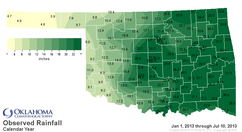
Go back a bit farther and you can see the year-to-date statistics reflect the
relief in the east and the continued drought in the west. The statewide average
since January 1 was 19.02 inches, only an inch below normal and the 44th driest
Jan. 1-July 10 on record. But out west the statistics are much worse. The
Panhandle, for instance, has had an average of 7.1 inches, 4.7 inches below
normal and the 10th driest such period since 1921. West central Oklahoma suffered
its 19th driest and southwestern Oklahoma its 25th driest. Remember, this is on
top of two-three years of drought.
-***-
Region Avg. Rainfall Dep. from Normal Pct of Normal Rank since 1921
Panhandle 7.05" -4.70" 60% 10th driest
N. Central 15.54" -1.87" 89% 42nd driest
Northeast 22.25" -0.08" 100% 36th wettest
W. Central 12.02" -4.45" 73% 19th driest
Central 24.29" +3.27" 116% 19th wettest
E. Central 25.70" +1.01" 104% 35th wettest
Southwest 13.21" -3.94" 77% 25th driest
S. Central 21.45" -1.03" 95% 42nd wettest
Southeast 27.88" +0.74" 103% 41st wettest
Statewide 19.02" -1.01" 95% 44th driest
-****-
Obviously central Oklahoma is sitting pretty in those statistics, but looking
at the maps, you can see the rapid drop off of relief to the west. For instance,
El Reno has had 26.4 inches of rain since the beginning of the year and Hinton,
a mere 20 miles away, has only had 13.8 inches. So a stark contrast indeed.

Unfortunately, it only gets drier from here, at least normally, through the
next few weeks. This is particularly bad news for some of those lakes out in
western Oklahoma.
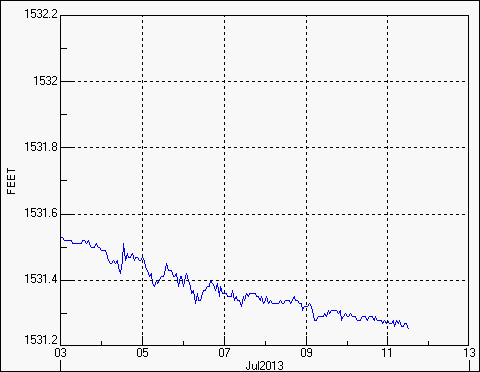
Canton Lake is now down to 18.7% of capacity and dropping steadily due to
evaporation. The same goes for Lake Altus-Lugert (15% capacity) and Tom Steed
(29% capacity).


Skiatook Lake up in northeastern Oklahoma is not doing too well itself, now down
to 78% capacity and also dropping pretty steadily.

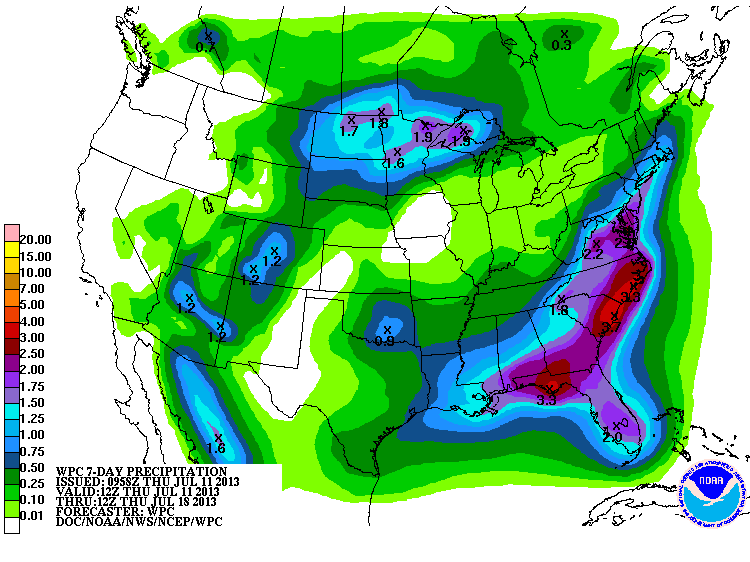
The solution remains simple, yet difficult given the season. We need rain. The
7-day has a bit of hope, but not for those areas still in the most dire need
of moisture.
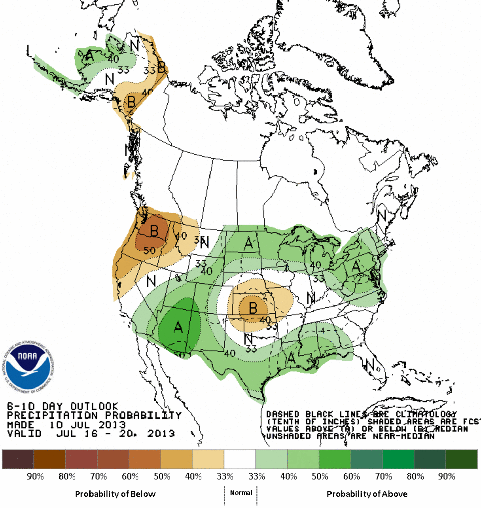
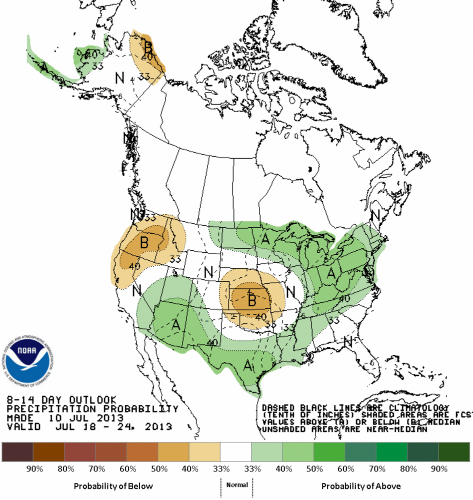
The medium range outlooks from CPC continue to mock us, surrounding us with
increased odds of above normal moisture, leaving us in the below normal side
of the spectrum.
Farther out, it's still summer! What do you think our chances of drought-
relieving rains are? If you go with what's "normal" ... lotsa luck!
Gary McManus
Associate State Climatologist
Oklahoma Climatological Survey
(405) 325-2253
gmcmanus@mesonet.org
July 11 in Mesonet History
| Record | Value | Station | Year |
|---|---|---|---|
| Maximum Temperature | 111°F | KIN2 | 2009 |
| Minimum Temperature | 52°F | GOOD | 1999 |
| Maximum Rainfall | 4.62 inches | SULP | 2023 |
Mesonet records begin in 1994.
Search by Date
If you're a bit off, don't worry, because just like horseshoes, “almost” counts on the Ticker website!