Ticker for June 21, 2013
MESONET TICKER ... MESONET TICKER ... MESONET TICKER ... MESONET TICKER ...
June 21, 2013 June 21, 2013 June 21, 2013 June 21, 2013
The heat is on
No jokes about Axel Foley and "Beverly Hills Cop" here, just the start of another
long Oklahoma summer (it actually started a couple of weeks ago on the
thermometer, and three weeks ago on the climatological calendar). Temperatures
tried to beat the calendar yesterday and zoomed up the dial once again. Actual
air temperatures weren't too bad across much of the eastern two-thirds of the
state, but neared triple-digits across parts of western Oklahoma.

Not really a shock that it's hotter out west, at least on the actual temperature
side. That's where the drought still going strong (remember, without
soil moisture to evaporate or lots of green vegetation to absorb sunlight, more of
the sun's energy goes towards heating the surface). HOWEVER, remember all that
rain we had across the eastern two-thirds? Well, the sun is going to work on it.
Check out the heat index map from yesterday.

Now the dry air of the west works in their favor. With less water vapor in the
air, the ability of the air to evaporate those sweat droplets on your skin goes
up, so your body's method of air conditioning becomes more effective. With
more water vapor in the east, that ability is diminished. If you go stand in
direct sunlight, of course, it's going to be blazing hot anywhere in the state.
So don't do that.
It looks as if our streak of four straight months with below normal temps might
be coming to an end. According to the Mesonet, our statewide average temperature
through the 20th was 75.7 degrees, as opposed to the normal of 75.4 degrees. With
an extended stretch of hot weather ahead of us, things look good (or bad) to
keep that mark above normal.
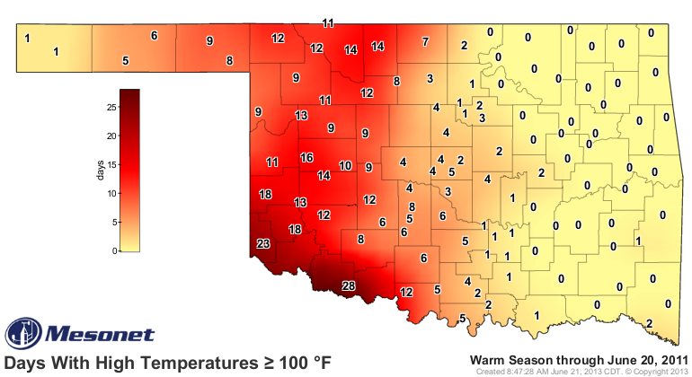
It will be good to keep perspective as the heat sets in. After all, it can't
be worse than 2011! Here are the number of days above 100 through June 20 of
that year.
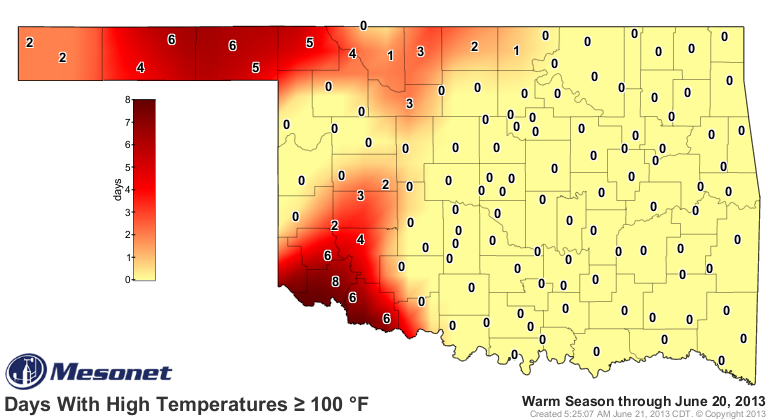
Versus this year.
If that doesn't help you in the next couple of weeks, just remember this term:
"ARGH!"
Gary McManus
Associate State Climatologist
Oklahoma Climatological Survey
(405) 325-2253
gmcmanus@mesonet.org
June 21 in Mesonet History
| Record | Value | Station | Year |
|---|---|---|---|
| Maximum Temperature | 107°F | HOLL | 1998 |
| Minimum Temperature | 52°F | KENT | 2004 |
| Maximum Rainfall | 6.57 inches | COOK | 2000 |
Mesonet records begin in 1994.
Search by Date
If you're a bit off, don't worry, because just like horseshoes, “almost” counts on the Ticker website!