Ticker for June 20, 2013
MESONET TICKER ... MESONET TICKER ... MESONET TICKER ... MESONET TICKER ...
June 20, 2013 June 20, 2013 June 20, 2013 June 20, 2013
One last improvement?
Upper-level death ridge Harvey (why just hurricanes and snowstorms?) appears ready
to move over the Southern Plains, so our rain chances might be few and far between
over the next week or so.
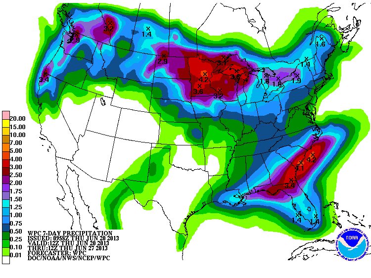
I'll go ahead and give an "oooh!" over the prospects of that bit of rain in the
Panhandle. "Oooh!" is the scientific term for "Gosh, I hope that really happens!"
With death ridge Harvey on the way, we have to thank our lucky stars that the first
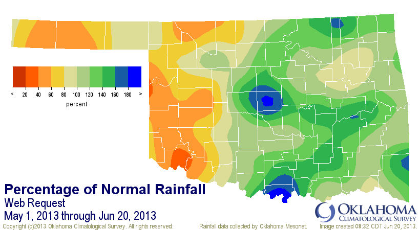
three weeks of June came through in the clutch with some great rains. Extend that
back to May and you see who was helped, and who wasn't (I did this a couple of
days about through June 18, but there was a bit of rain since then, especially
in the Panhandle).
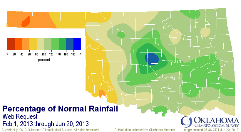
And, as I've said previously, we can trace the current drought improvement episode
back to February.

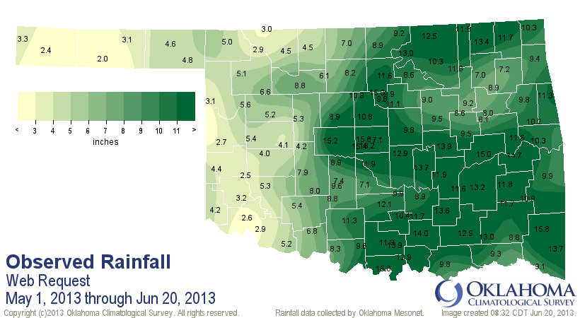
Those totals range from 29.7 inches at Mt. Herman to 3.1 inches at Boise City.
And 2.1 inches of that 3.1 fell in the last 30 days out that way. Luckily, and
hopefully speaking, they will get their share of the rains as the summer monsoon
kicks in out across the desert southwest. August is Boise City's wettest month
normally with a whopping 3.34 inches. June is #2 at 2.99 inches, so they're still
a bit below normal for the month thus far. And don't forget those areas down
across the southwest and north central Oklahoma that have stayed relatively
dry as well.
As Conan said when storming the castle in "Conan the Destroyer" ... enough
talk! Let's just take a look at the latest U.S. Drought Monitor map.
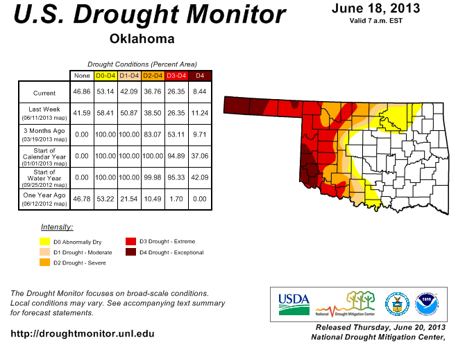
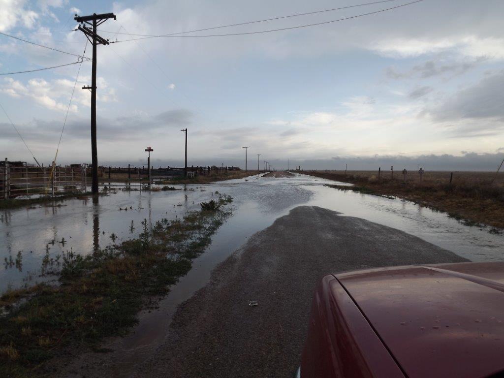
Not too shabby. We even got to reduce some of that D4 down to D3 in the eastern
Panhandle where some decent rains fell over the last few days. Heck, they even
had some standing water in some areas. Check out this pic sent to us from a
Ticker reader from southern Texas County (that's the middle one for those of you
that don't know your Panhandle geography ... and SHAME on you!).
But, those folks are getting ready to go back into the convection oven. Highs
as Death Ridge Harvey moves in should climb back close to triple digits over
the next few days. Watch for triple digits next week.

The only question is, will it be windy out there?
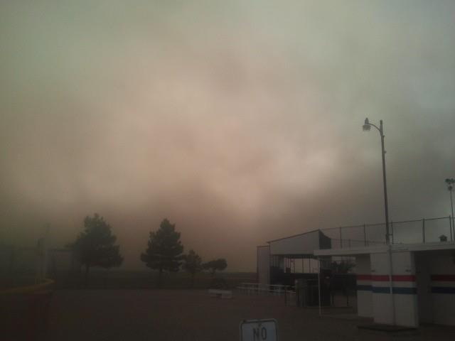
HAHAHAHAHAHA! I crack myself up. When is it NOT windy out there? Winds should be
gusting to 35-40 mph throughout the period. That will make quick work of that
moisture. Hopefully it's soaking in. This was the view just north of the border
from Boise City and Kenton, sent to us from the NRCS folks out that way. Just
more proof that the rains don't go that far when it's hot and windy and the
ground gets little of the runoff. Cimarron County blew too, from their reports.
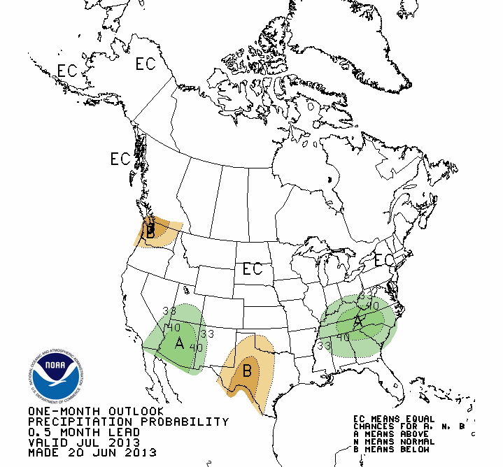
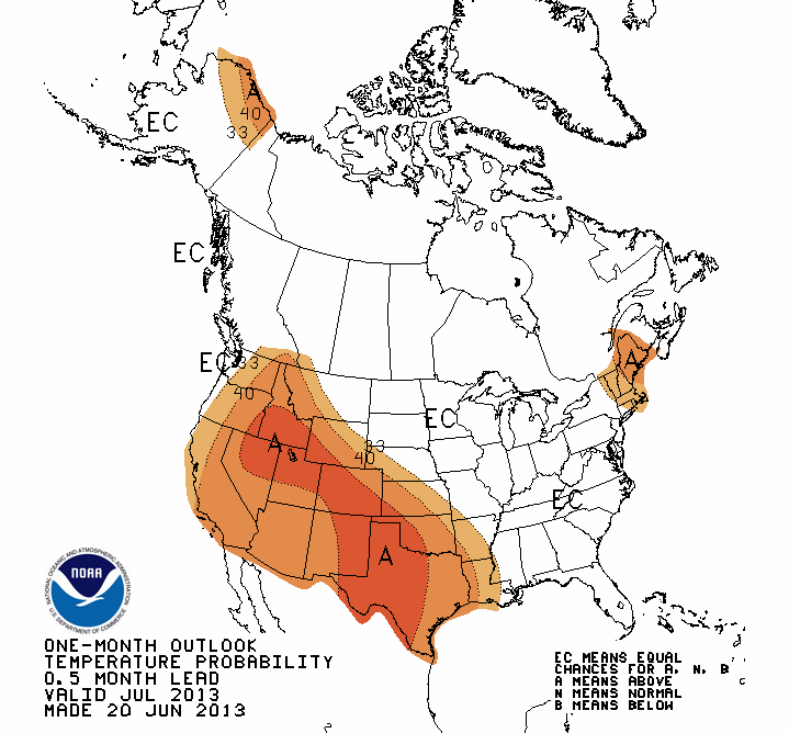
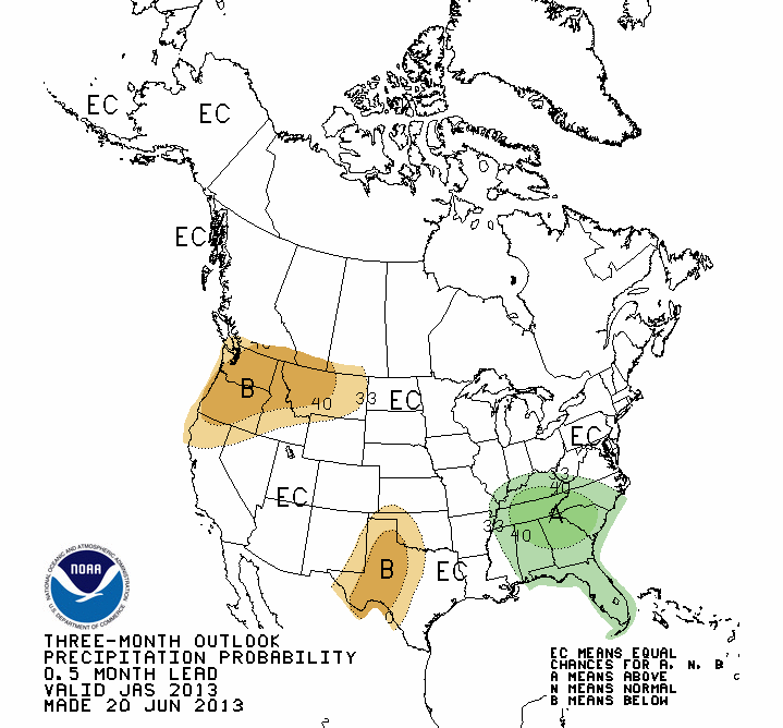
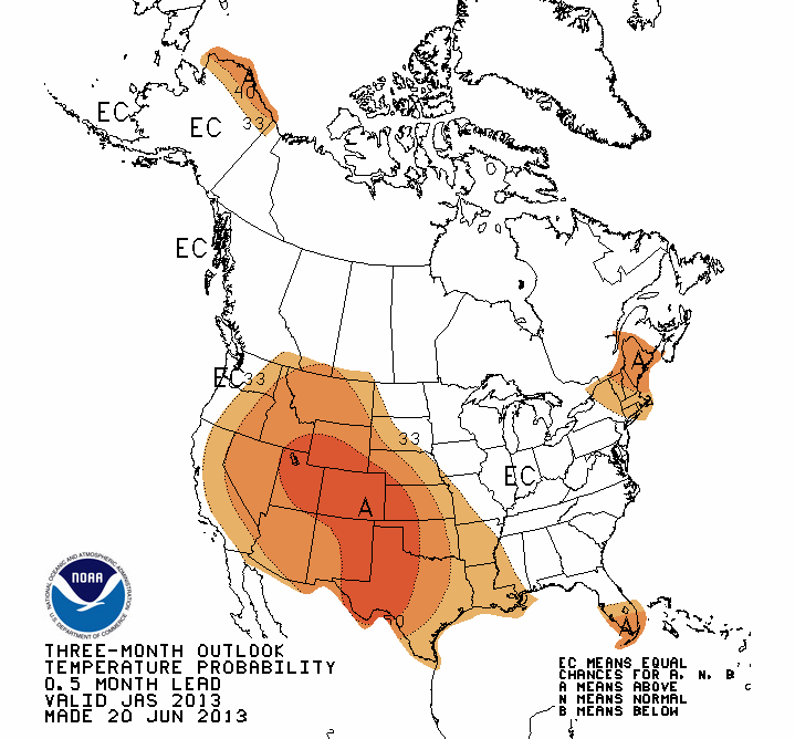
Now let's take a look a bit farther in the future. The new outlooks for July
and the July-September period from the NWS' Climate Prediction Center show
some unsurprising forecasts: increased odds for above normal temps for all of
us, and increased odds of below normal precip in the west.
July Outlooks
July-September Outlooks
Those outlooks lead to this view from the U.S. Seasonal Drought Outlook (hold
onto your hats ... it ain't pretty for western Oklahoma).
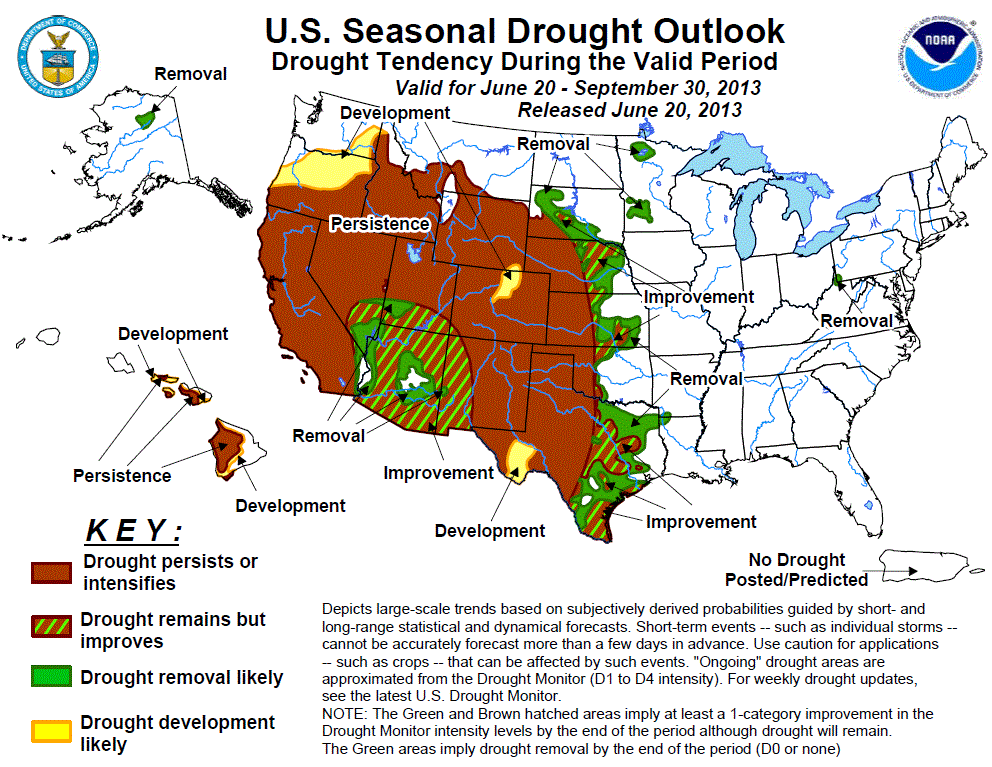
Pretty obvious that if you are expecting above normal temps and below normal
precip during the summer across areas already hit by drought, you should
probably expect that drought to intensify or at least persist.
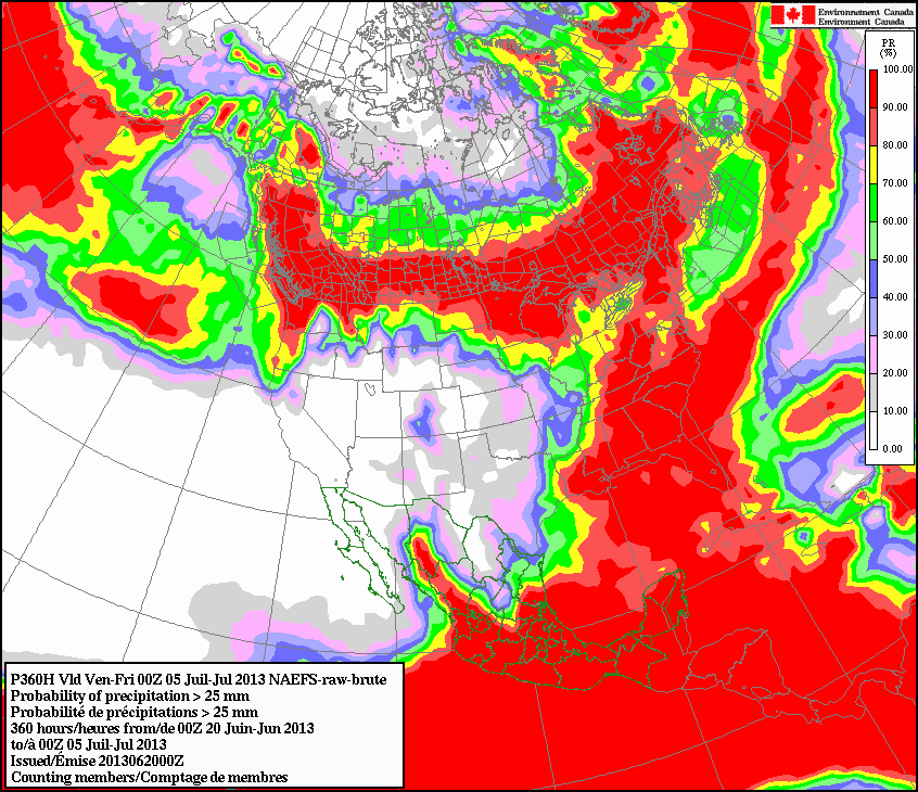
The Canadian forecast model ensemble shows the chances of accumulating at least
an inch of rainfall to be slim to none at least through the July 4 holday
period. You can also see a clear impact of that upper level ridge (what was his
name again?) out west. This will not be good news for western Oklahoma, the
Panhandle or those folks suffering from the fires in Colorado. This map is
for June 20-July 5.
Let's end on some good news, however. Look at how far most of the state has come
since the start of the water year (Oct. 1, 2012) on these Drought Monitor change
maps. Much of central and eastern Oklahoma has improved by at least 4 categories!

Now, it's time for Harvey to go back to starring in Jimmy Stewart movies!
Gary McManus
Associate State Climatologist
Oklahoma Climatological Survey
(405) 325-2253
gmcmanus@mesonet.org
June 20 in Mesonet History
| Record | Value | Station | Year |
|---|---|---|---|
| Maximum Temperature | 112°F | MANG | 1998 |
| Minimum Temperature | 52°F | KENT | 2000 |
| Maximum Rainfall | 4.32 inches | BOWL | 2007 |
Mesonet records begin in 1994.
Search by Date
If you're a bit off, don't worry, because just like horseshoes, “almost” counts on the Ticker website!