Ticker for June 12, 2013
MESONET TICKER ... MESONET TICKER ... MESONET TICKER ... MESONET TICKER ...
June 12, 2013 June 12, 2013 June 12, 2013 June 12, 2013
My kingdom for a pipeline!
One of the more obvious long-term impacts of drought is a reduction in reservoir
levels. We certainly saw that last year when our mostly-full lakes and reservoirs
in May 2012 were transformed into mudholes (relatively speaking) by late fall.
Now we're back to mostly full again, at least across the eastern two-thirds of
the state. In fact, I'd say we're in better shape this year than we were at this
time last year. Several folks have asked me about a current lake level chart,
so take a look at all the overflowing lakes across the state.
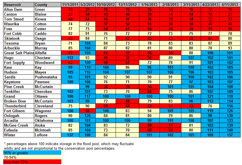
You can take a look back at the May 2, 2012, column and see very similar results,
but a month previous. So we're at least into the summer with lots of full lakes.
Lake Thunderbird appears to be the big winner recently, going from 76% of
capacity a couple of months ago to flood stage (the flood stage numbers are
sometimes inaccurate, but they still indicate a lake into its flood pool). From
last May, it would appear Waurika and Foss are faring worse this go around.
Not really a shock there, since those lakes remain in drought plagued areas.
Showing that chart, I will get requests to put it on a map, so I got out the
crayons (the box of 64 WITH the sharpener ... WHOO-HOO!) and produced this crude
map. Things got a bit tight over in eastern Oklahoma, so I tried to make sure
each box was centered under or over the star particular to that lake's location.

Only Skiatook, Arbuckle and Texoma are down across the eastern half of the state.
In the west, Fort Supply and Great Salt Plains are in flood stage. The
obvious trouble area is from Canton down to Waurika, including all of
southwestern Oklahoma. And the big problem for those lakes is ... they ain't
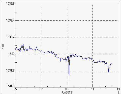
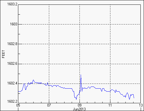
getting any better with all this heat and wind. Take a look at their recent
elevation charts and notice their slow decline. We'll use Canton and Altus as
examples.
We're now past the finish line I've been talking about from spring to summer,
and those areas lost the race. Mother Nature now kicks evaporation into overdrive,
not to mention those plants that are growing, sucking the moisture from the
soils. As those parched soils and spots of bare earth absorb that sunlight, that
will only create more heat and evaporation. Drought intensification WILL occur
without more rainfall. Ideally, spring would have been the time to moisten those
soils and fill those lakes (see: eastern and central Oklahoma). But that didn't
happen.
It can still rain. It's not unheard of in Oklahoma. To get enough to outpace
the evaporative demands ... that's a bit more rare. With more temperatures and
winds like this (and it doesn't even show the 107 degrees from Guymon yesterday)
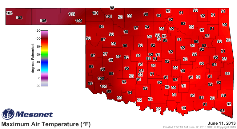
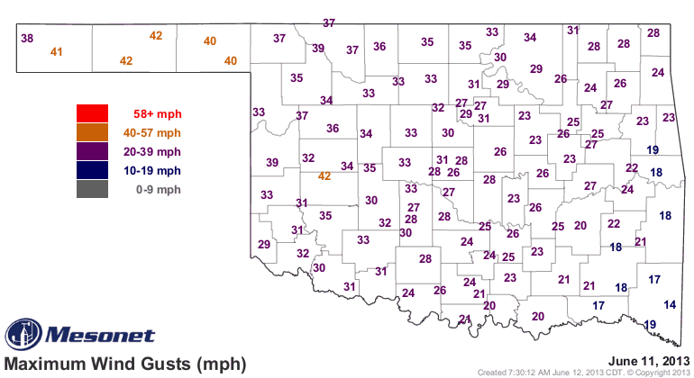
and things will go downhill in a hurry. The trouble is, a lot of this area is
already at the bottom of the hill.
Where's Sisyphus when you need him?
Gary McManus
Associate State Climatologist
Oklahoma Climatological Survey
(405) 325-2253
gmcmanus@mesonet.org
June 12 in Mesonet History
| Record | Value | Station | Year |
|---|---|---|---|
| Maximum Temperature | 110°F | ALTU | 2022 |
| Minimum Temperature | 44°F | KENT | 2011 |
| Maximum Rainfall | 6.15 inches | ACME | 2016 |
Mesonet records begin in 1994.
Search by Date
If you're a bit off, don't worry, because just like horseshoes, “almost” counts on the Ticker website!