Ticker for May 30, 2013
MESONET TICKER ... MESONET TICKER ... MESONET TICKER ... MESONET TICKER ...
May 30, 2013 May 30, 2013 May 30, 2013 May 30, 2013
One May is not like another
Yesterday's severe weather outbreak DID occur, but with little tornadic action.
We had tornado watches out the wazoo, and even a few tornado warnings, but no
violent twisters touching down. I'm not saying there wasn't a tornado touch-down
or two scattered about, but nothing like the May 19-20 damaging hoses. There was
a report of a tornado by the Erick police dept. 11 miles SE of Sayre in Beckham
County in the storm reports, so we'll see if that (and any others) verifies.
We did have several large bow echo thunderstorm formations move from west to east
across Oklahoma, however, and that brought lots of lightning, hail and wind
damage. That wind damage shows up pretty well on the Mesonet maximum gust maps
from yesterday and today (thus far).
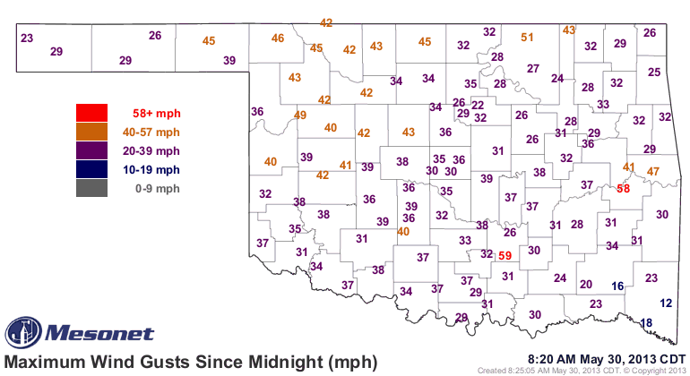
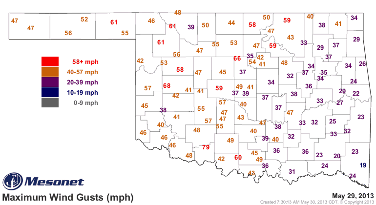
Those 45-55 mph wind gusts in the Panhandle are non-thunderstorm winds behind
the dryline, by the way. That means dust storm action. One beneficial attribute
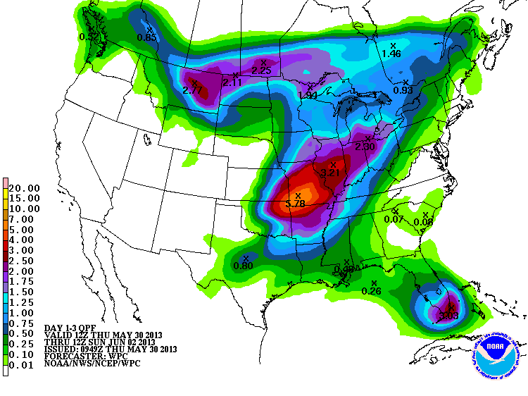
of the storms was the prodigious rainfall that occurred as a by-product. The
Mesonet rainfall maps show Red Rock up in Noble County had more than 5 inches of
rainfall from training thunderstorms (I'll go back three days to capture all
the rains from the current system).
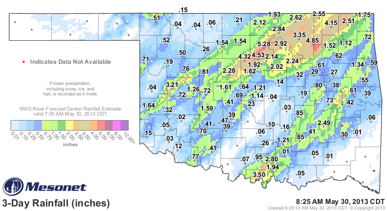
In fact, that area from Kingfisher County through Nowata County got blasted by
widespread 3-5 inch amounts. There was also obviously a pretty potent storm
that traveled from Beckham County through Kay County, dumping 1-2 inches in
general, with 3.21 inches measures at the Butler Mesonet site. AND there was
another area of storms that went from Love County in the south to Cherokee
County in the northeast, dropping 1-3 inches along the way, with localized
heavier amounts.
Now, that brings us to yet another anticlimactic U.S. Drought Monitor map, since
we'll see lots of changes next week, probably. But for some, the map is still
quite accurate. We once again saw that D4 spread just a little bit across far
western Oklahoma, and it ha snow crept up to cover 11.34% of the state. At the
same time, the amount of D0-D4 has gone down from 75% to 68%. What that says is
that drought is intensifying in the west and going away in the east.
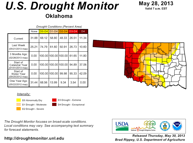
What that means is that central through eastern Oklahoma is winning the race to
the summer heat, while the western (along with southern and northern Oklahoma)
area is losing the race. We will see more improvements next week just from what
rain has already fallen, and remember there is more yet to come in the next
few days!
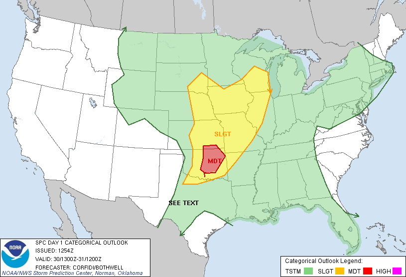
Chances for severe weather continue today, so all the cautions you've been
hearing lately still apply. It does appear the main threat has shifted farther
to the east.
The difference in the last three months of May are very obvious, from 2012's
bone dry version to 2011 and 2013's scattered-here-and-there heavy rains.
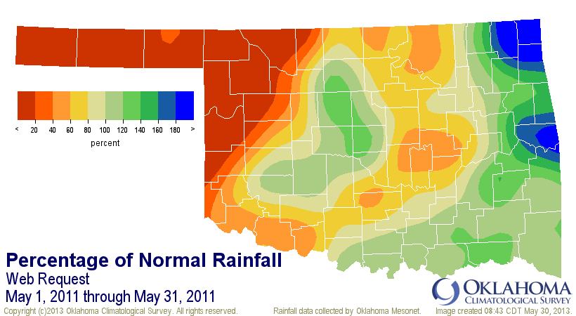
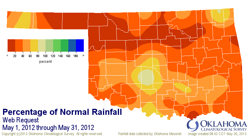
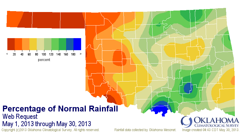
However, there are also similarities. The one obvious similarity between all
three is that western Oklahoma is in big trouble in all three, with percent
of normal values less than 40% in all three. And 2011's statewide average of
4.44 inches is very close to this year's May statewide average of 4.26 inches
(that's sure to change with two days left in the month, however).
The overriding message, then, is that the rains are welcome across the eastern
two-thirds of the state, but the western third (as well as northern and southern
Oklahoma) HAS to get theirs eventually, or bad things will continue to get
worse out that way.
Gary McManus
Associate State Climatologist
Oklahoma Climatological Survey
(405) 325-2253
gmcmanus@mesonet.org
May 30 in Mesonet History
| Record | Value | Station | Year |
|---|---|---|---|
| Maximum Temperature | 107°F | ALTU | 2003 |
| Minimum Temperature | 39°F | EVAX | 2019 |
| Maximum Rainfall | 4.47 inches | EUFA | 2001 |
Mesonet records begin in 1994.
Search by Date
If you're a bit off, don't worry, because just like horseshoes, “almost” counts on the Ticker website!