Ticker for May 28, 2013
MESONET TICKER ... MESONET TICKER ... MESONET TICKER ... MESONET TICKER ...
May 28, 2013 May 28, 2013 May 28, 2013 May 28, 2013
All it takes is a weekend...
No, this isn't "The Hangover, Pt. 4" or anything, and it doesn't even really
pertain to a weekend. It's more of a two-day example. The complacency
that often sets in with severe weather awareness in spring when the numbers seem
to be persistently diminished can certainly do an abrupt about-face with just
one or two big severe weather days. So while May was cruising along much cooler
than normal with few tornado chances through the first 18 days (only two very
weak tornadoes struck in those first 18 days), one good (in this case, bad)
storm system brought all the heat, moisture and proper upper- and lower-level
wind support necessary to change Oklahoma's weather history. The result was AT
LEAST 19 tornadoes touching down on May 19 and 20, including two EF2s, one EF3,
one EF4 and one EF5 (preliminary data accumulated by super duper tornado
statistician Doug Speheger of the Norman NWS office). And those numbers can only
go up as more possible tornadoes are investigated.
That brings the total for 2013 (again, preliminary) up to 37:
-***-
Month Count Average (1950-2012)
January: 2 0.3
February: 0 0.8
March: 2 4.0
April: 12 11.7
May: 21 21.4
Totals: 37 38.2
-****-
So boom (and believe me, I heard the boom!), just like that we're back up to
average for the year, and probably above average when the surveys are done.
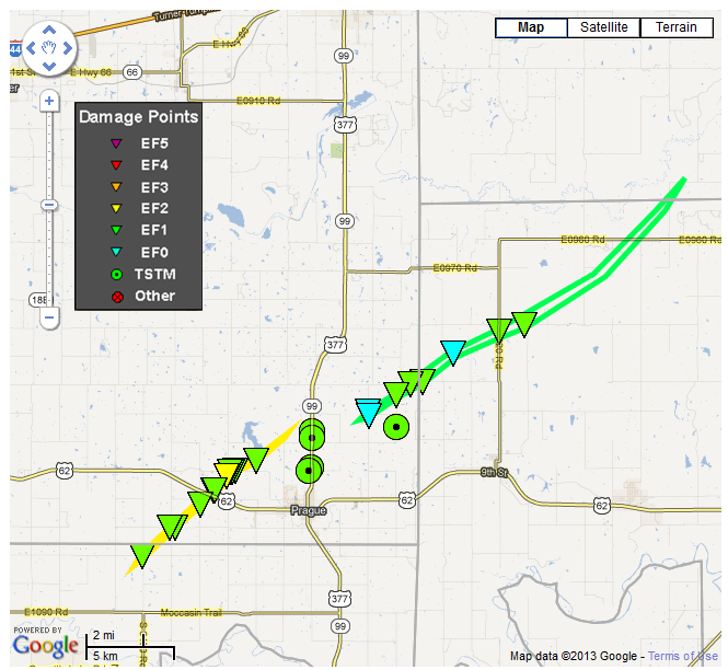
And speaking of May 19-20, the local NWS offices in Norman and Tulsa have some
pretty handy maps that show some of the tornado tracks.

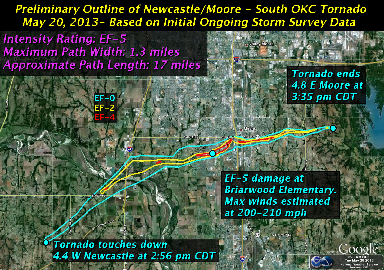
Of course, the Moore/S OKC tornado is garnering much of the attention, much to
the consternation of those other communities impacted by significant tornado
damage. I understand the frustration ... I'm from the Panhandle (almost)! My
sense, however, tells me that when folks see demolished elementary schools,
that's going to draw the spotlight that way. So here's a bit more spotlight.
You can find many of these online from many different sources, but here is the
surveyed tornado track and tornado intensity map of the Moore tornado from
the Norman NWS office.
Here are some accumulated statistics from the two-day tornado outbreak from
OEM and FEMA.
"Oklahoma Department of Emergency Management (OEM) and the Federal
Emergency Management Agency (FEMA) have compiled the damage assessment
data for storms that took place May 19-20. According to preliminary
aerial assessments, the storm impacted 3937 homes, businesses and
non-residential buildings in Cleveland, Lincoln, McClain, Oklahoma
and Pottawatomie counties. Of those, 1248 were destroyed, 452 sustained
major damage, and 640 sustained minor damage."
There were 26 fatalities due to the tornado outbreak ... 2 deaths on Sunday and
24 on Monday.
Now for the more troubling part. Not only could the tornado total go up due to
further surveys, but also due to more severe weather over the next few days.


Now, do I need to remind you to be weather aware? I'm thinking probably not.
Mother Nature has our attention once again.
Gary McManus
Associate State Climatologist
Oklahoma Climatological Survey
(405) 325-2253
gmcmanus@mesonet.org
May 28 in Mesonet History
| Record | Value | Station | Year |
|---|---|---|---|
| Maximum Temperature | 105°F | BEAV | 2022 |
| Minimum Temperature | 39°F | KENT | 2016 |
| Maximum Rainfall | 4.53 inches | MANG | 2023 |
Mesonet records begin in 1994.
Search by Date
If you're a bit off, don't worry, because just like horseshoes, “almost” counts on the Ticker website!