Ticker for May 20, 2013
MESONET TICKER ... MESONET TICKER ... MESONET TICKER ... MESONET TICKER ...
May 20, 2013 May 20, 2013 May 20, 2013 May 20, 2013
May-hem
Obviously, the big weather story is the severe weather outbreak that occurred over
the weekend. And another "obviously," that story is still fluid as emergency
personnel continue to search wreckage and account for the missing and injured.
Some of those areas hardest include Cushing, Edmond, Norman, Lincoln County, and
the Shwanee/Pottawatomie County area. Over 23,000 customers remain without power
due to the storms. The Governor's office has declared a state of emergency for
16 Oklahoma Counties: Caddo, Cleveland, Comanche, Creek, Garfield, Grant, Greer,
Kiowa, Lincoln, Logan, McClain, Okfuskee, Oklahoma, Pawnee, Payne and Pottawatomie.
The Oklahoma Mesonet recorded many gusts of over 40 mph associated with both the
storms and with the general conditions yesterday.

And there was also areas of torrential and flooding rainfall where the biggest
of those storms formed and re-formed. Kiowa County was hard hit this time, as was
Osage County. Both of those regions measured 2-3 inches in the Mesonet gauges,
but also had areas from radar estimates of 3-4 inches.
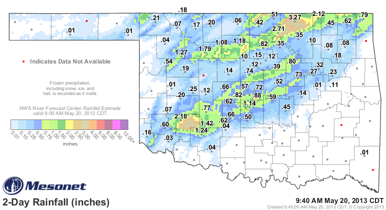
Still not nearly enough across western and south central Oklahoma, but I think
those folks would rather pass if the rain is going to come accompanied by
softball size hail and tornadoes.
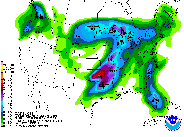
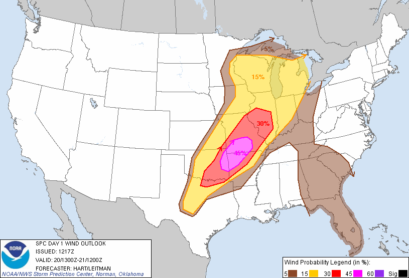
With a very similar severe weather setup in store for us tonight, more rainfall
will be possible (unfortunately, also accompanied by all sorts of bad things).
Here is the rainfall forecast for the next couple of days.
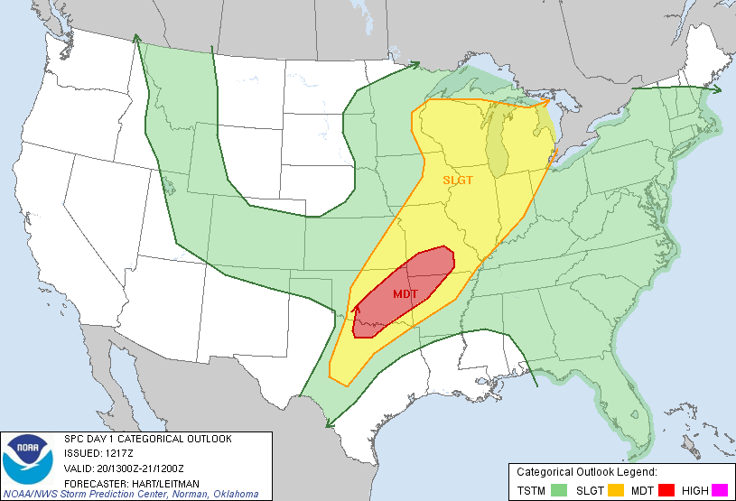
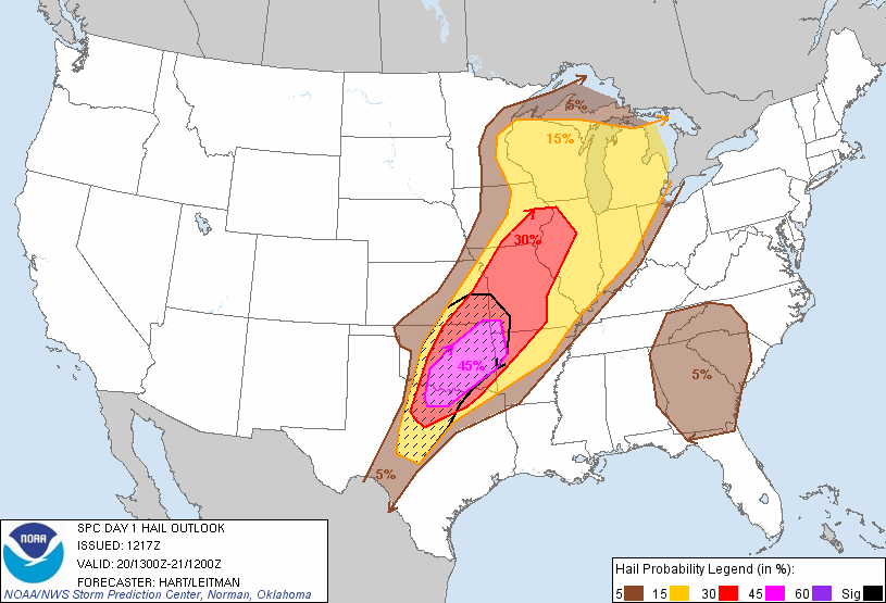
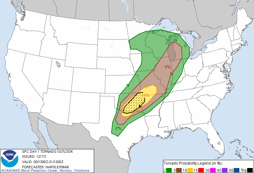
The Storm Prediction Center (SPC) has the main severe threat across the
southeastern half of the state, perhaps along and a bit north of I-44. Watch
for increased chances of large hail, severe winds and even tornadoes in these
areas.
For more up-to-date weather information, be sure to stay tuned to your favorite
media outlet and for sure keep checking with your local NWS offices!
http://www.srh.noaa.gov/oun
http://www.srh.noaa.gov/tsa
http://www.srh.noaa.gov/shv
http://www.srh.noaa.gov/ama
Those four NWS office cover the entire state. The Norman and Tulsa offices will
be particularly busy today.
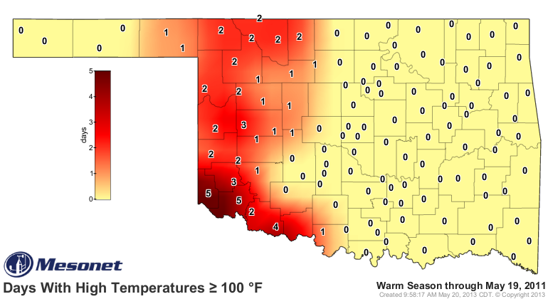
Somewhat lost in all the excitement was the fact that we saw our first triple-
digit temps across the state this weekend. It's not shocking at all that it
occurred in the extreme southwest and Panhandle...the two areas hardest hit
by the current drought.

That's a bit behind schedule compared to last year at this time, where the
southwest already had as many as 5 days at or above 100 degrees. The same for
2011 (anybody remember that summer??), although 2011 had more widespread triple-
digit weather by May 19.

Personally, I'll take the 100s over the tornadoes. But both can build in a
hurry. As the weather professionals in the state have been warning about all
alone, a slow year can turn into a busy one with one day.
Or two? Stay tuned.
Gary McManus
Associate State Climatologist
Oklahoma Climatological Survey
(405) 325-2253
gmcmanus@mesonet.org
May 20 in Mesonet History
| Record | Value | Station | Year |
|---|---|---|---|
| Maximum Temperature | 104°F | ALTU | 2006 |
| Minimum Temperature | 35°F | EVAX | 2017 |
| Maximum Rainfall | 6.44 inches | SKIA | 2019 |
Mesonet records begin in 1994.
Search by Date
If you're a bit off, don't worry, because just like horseshoes, “almost” counts on the Ticker website!