Ticker for May 7, 2013
MESONET TICKER ... MESONET TICKER ... MESONET TICKER ... MESONET TICKER ...
May 7, 2013 May 7, 2013 May 7, 2013 May 7, 2013
Spring has sprung again ... wheat going downhill
It looks as if we have vanquished the cold weather vermin for a little while,
and now we're getting a bit of spring back in our steps. This is after the
summer burrito we had last week with highs in the 80s and 90s surrounded by lows
in the 20s and 30s. Lots of records were set ... lowest maximum temps, lowest
minimum temps, most grouchy associate state climatologist that hates cold
weather temps, etc. Within that period, we also saw our coldest and 4th-coldest
days in May for the state since records began. These are based on statewide
average temperatures, so take all the highs and lows, add 'em up and get the
average. Much too simple methodology, but effective for what we're trying to show.
Here are the top 5 coldest days in May.
2013-05-02 44.4F
1954-05-03 44.9F
1935-05-04 45.9F
2013-05-04 46.7F
1953-05-13 47.3F
A strange correlation there - all of those days occurred during periods of
extreme long-term drought, at least for parts of the state. Related? Hard to
say, but intriguing nonetheless.
To punctuate that the cold "snap" was more than a snap, the 4-day period ending
on May 5 was easily the coldest 4-day span on record for May with a statewide
average temperature of 47.7 degrees, 1.7 degrees ahead of the 4-day period
ending on May 2, 1994 (so that one had some April days to help).
After "Apruary" (our April that resembled February), the pressure was building
to find out a term for our cold-looking May. I had many suggestions:
Mayrch
Manuary
Maybe Not
Macember
Maybespringwillcome
Luckily, it appears the cold weather has exited stage left (or right, I guess).
It looks as though we'll continue to see seasonable to above-seasonable
temperatures for awhile.
http://www.mesonet.org/index.php/forecast/air_temperature/
--------------------------------------------------------------------------------
Winter wheat is ailing
Thanks (but no thanks) to the cold weather and drought, the condition of winter
wheat across the U.S. is bad and getting worse all the time. Oklahoma's crop
is now at 45% poor to very poor with only 20% at good to excellent. That's well
behind last year's ratings of 4% poor to very poor and 76% good to excellent.
But things are tough all over. Check out this summation from our friends at
the USDA.
https://content.mesonet.org/ticker/archive/20130507/WinterWheat-Condition-05-07-1.pdf
The winter wheat rated poor to very poor nationally went up 32% since last
week alone, and up 12 % from last year! That's an increase in one week from
7% poor/very poor to 27% poor/very poor. And the good to excellent wheat across
the U.S. went down 36% since last week, and 14% since last year. Texas, South
Dakota, OK, Nebraska, Kansas and Colorado are all seeing crop conditions
diminish.
I guess that says if you're sitting on a nice crop that hasn't been hampered
since planting by drought, or damaged by the late-spring frosts ... count your
lucky stars!
-------------------------------------------------------------------------------
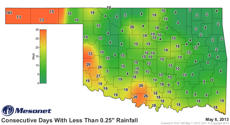
Our next rain
Rain is still needed, particularly across western Oklahoma. We're now up to 143
days without a quarter-inch of rain in a single day in the Kenton area, and at
least 73 days for the western two-thirds of the Panhandle. Creeping up to a
month or more across west central and southern Oklahoma as well.
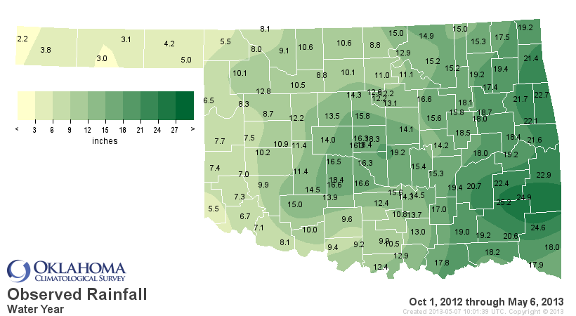
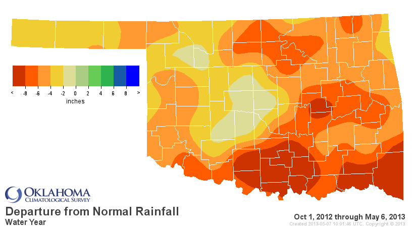
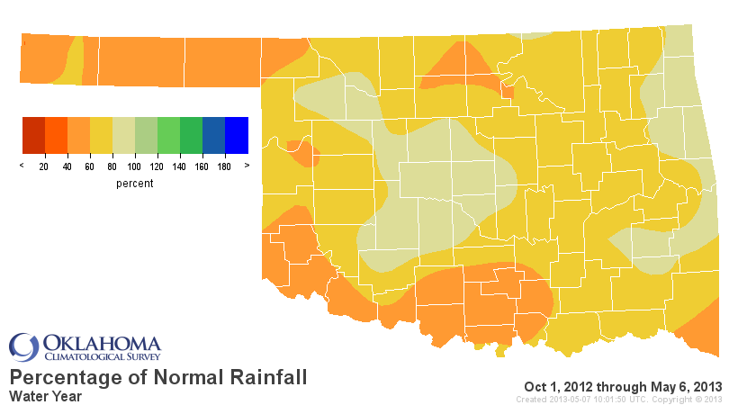
Despite the recent relief in February and April, our long-term deficits are
still significant across most of Oklahoma. Here are the maps for the water year
thus far (Oct. 1, 2012 - May 6, 2013).
So yes, we are still in desperate need of a rain! We see chances of the wet
stuff from tonight through Saturday, and the forecast totals across northern
Oklahoma range from 1-2 inches.
We really REALLY need to shift that rain to the south and east as well. I'm
giving a drought talk in Altus next week and I need those folks in a good mood.
Otherwise, they might throw me in Lake Altus-Lugert.
Oh, I'm not worried about drowning. I'm worried about hitting my head on the
bottom.
Gary McManus
Associate State Climatologist
Oklahoma Climatological Survey
(405) 325-2253
gmcmanus@mesonet.org
May 7 in Mesonet History
| Record | Value | Station | Year |
|---|---|---|---|
| Maximum Temperature | 104°F | GRA2 | 2000 |
| Minimum Temperature | 32°F | KENT | 1999 |
| Maximum Rainfall | 6.81 inches | LANE | 2007 |
Mesonet records begin in 1994.
Search by Date
If you're a bit off, don't worry, because just like horseshoes, “almost” counts on the Ticker website!