Ticker for May 3, 2013
MESONET TICKER ... MESONET TICKER ... MESONET TICKER ... MESONET TICKER ...
May 3, 2013 May 3, 2013 May 3, 2013 May 3, 2013
Carlito's Winter
Hey Winter, you think you bigtime? YOU GONNA DIE BIGTIME!
Okay, maybe "Carlito's Way" isn't the best movie analogy to use with this
winter, since Carlito did die at the end. Sorry, SPOILER ALERT! But I feel
emboldened since it is May, and this cold weather can't last forever. Can it?
More records fell this morning. Here's a look at the low temperature map from the
Mesonet vs. the record lows for May 3.
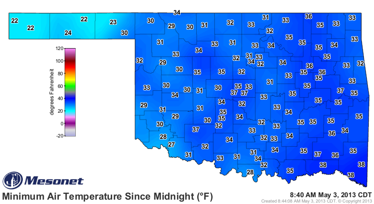

Looks like those records were shattered in the Panhandle, and nearly met or
actually broken over much of the rest of the state. That's not all ... snow fell
across NE OK overnight. Tulsa got at least a trace, marking the latest snowfall
on record for those folks. Stilwell in Adair County reported about 2 inches of
the white stuff.
The number of hours below freezing map for the month of May thus far doesn't
look too bad, until you remember IT'S MAY!
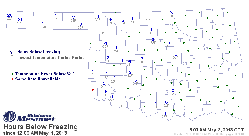
Notice down there in the far southwest where the drought is still labeled as
exceptional that those folks seem to be a bit high on the freezing hours. I'm
guessing that's a by-product of the dry conditions down there. Not much
moisture down there to condense to release heat and keep the temperatures up
a bit. That part of the state got scoured pretty well yesterday by wind. They
were having 50-60'ish mph winds all day yesterday. I don't care how cool it is,
that will do a lot of damage to the already-depleted soil moisture.

Remember a few days ago I mentioned that we might see the coldest May day on
record for the state? Well, it happened yesterday. With a statewide average of
44.4 degrees (Mesonet), that beats the previous coldest May day of 44.9 degrees
from May 3, 1954.
Now, here are a few weird facts about 1954. That May ended up as the 5th coldest
on record for the state, but the summer of 1954 was the 4th hottest (and the
10th hottest summer on record for ANY state). And, made famous by its race with
2012 last year, 1954 was previously the hottest year on record for Oklahoma
(again, beaten by 2012, knocking it down to 2nd place). Now the difference
here is that the first four months of 1954 were extremely warm, much like last
year in Oklahoma. So we have a divergent path already between the two years, and
panic about this summer is not really necessary just yet. Oklahoma summers
are tied temperature-wise to how much rainfall we get during that season, but
also if drought is in place. And 1954 was smack dab in the middle of Oklahoma's
worst drought of record. April and May 1954 were fairly wet, just like this year
(so maybe have a *little* bit of panic).
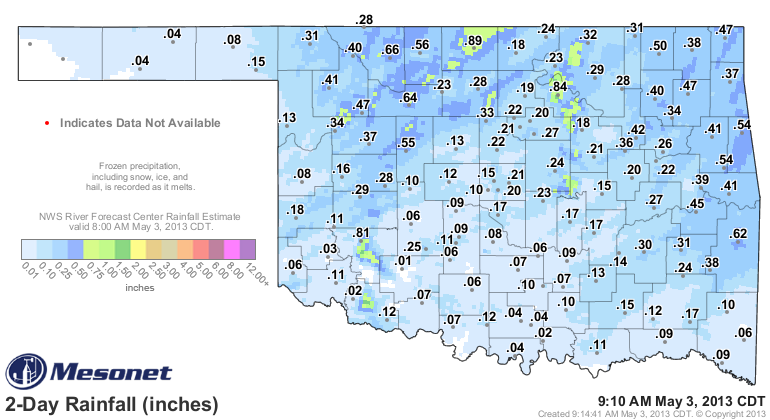
Speaking of rain ... it didn't end up as much, but a nice general soaking for
of a quarter- to half-inch across northern Oklahoma. Those hardest hit areas of
far western Oklahoma and the Panhandle missed out again, however. The wind
made most of the rainfall across southern Oklahoma moot anyway.
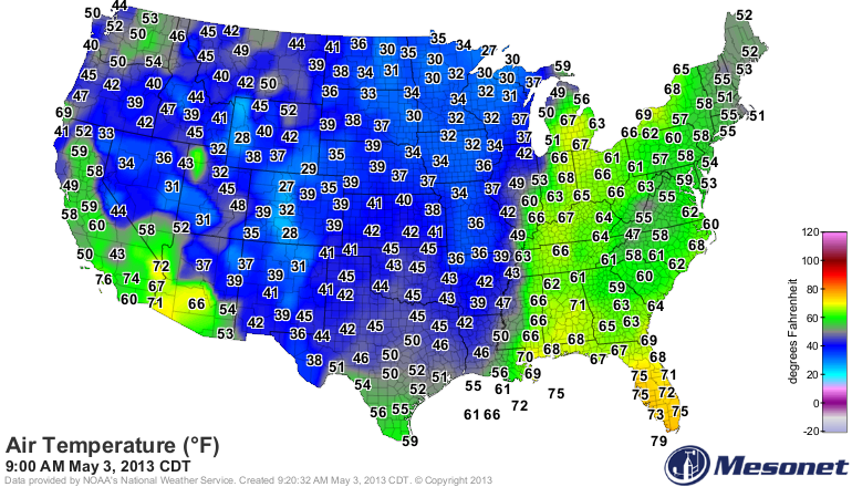
Why is this happening? Why is all this cold air getting shuffled down into
the central U.S.? Well, you can blame that large are of blocking high pressure
over the northwest Atlantic. One of the Drought Monitor authors sent this link
out this morning, showing the block on the satellite loop. As long as that
blocking high sits there, the storm systems have a tough time progressing in
the pattern and the cold air that has built up in the still-cold arctic has
nowhere to go. That cold air eventually slams down through the central U.S.,
giving us our frigid conditions while keeping the western and eastern thirds of
the country baking. Here's the U.S. Temperature map demonstrating that plunge
of arctic air.
I'll just post his explanation of the satellite image and then the link.
"On the latest satellite loop, our quasi-famous northern Atlantic
blocking high has migrated into view. Of course, this means it's
no longer over the north Atlantic, but now more like the northwestern
Atlantic, but it is pretty cool. You can make out the high's clockwise
rotation, and also see how it is forcing everything to stall, and
anything within its immediate vicinity to go backwards - west/southwest
- toward the southeastern U.S. coast. It is giving us fantastic
weather here in the Mid-Atlantic, while the central Corn Belt gets
snow and the Southeast gets soaked! Snow lovers ? like me ? like to
see this blocking high in the winter, in its proper place of course
over the north Atlantic. With its more southwestward placement, all
the impacts are likewise shifted west and south. Anyhow, here's a
link to this morning's IR satellite loop; the feature I'm talking
about is centered over Nova Scotia in eastern Canada (right on the
coast) and is forcing the disturbances off the Mid-Atlantic coast to
move southwest."
http://www.ssec.wisc.edu/data/us_comp/us_comp_big.html
Pretty cool stuff (pardon the pun)! Looks like there might be another cut-off
closed low late next week. Basically, an upper-level low pressure system south
of the main jet stream's steering winds (i.e., "cut off), meaning it tends to
meander around in a erratic fashion. We sometimes see these during the summer
as the jet stream retreats to the north. That's the pattern we saw during much
of June 2007 when it rained and rained and rained ... and rained, becoming our
wettest June on record. Not predicting that for this May, of course. There's a
reason cut-off lows are known as weatherman's woes. Very tough to forecast what
they're gonna do.
But it's another chance of good rain, possibly, and a chance to keep the summer
of 2013 from turning into the summer of 1954.
Gary McManus
Associate State Climatologist
Oklahoma Climatological Survey
(405) 325-2253
gmcmanus@mesonet.org
May 3 in Mesonet History
| Record | Value | Station | Year |
|---|---|---|---|
| Maximum Temperature | 101°F | ALTU | 2012 |
| Minimum Temperature | 22°F | BOIS | 2013 |
| Maximum Rainfall | 3.14 inches | MCAL | 2021 |
Mesonet records begin in 1994.
Search by Date
If you're a bit off, don't worry, because just like horseshoes, “almost” counts on the Ticker website!