Ticker for April 18, 2013
MESONET TICKER ... MESONET TICKER ... MESONET TICKER ... MESONET TICKER ...
April 18, 2013 April 18, 2013 April 18, 2013 April 18, 2013
Consider drought relieved ...
for a swath of Oklahoma about 30 miles wide, that is. Last night's attack by
Mother Nature left us with lots of tornado, hail and wind reports, but also
torrential rains. Rains are still falling as the storm system works its way out
of the state, but where those storms formed along yesterday's warm front and
trained to the NE is rather obvious from the rainfall map.

Medicine Park takes the prize for actual gauge-measured rain, with 6.63 inches
in a hurry. The bulk of that rain fell between 6pm and 8:45pm.
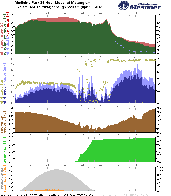
You can also see wind gusts there approaching 70 mph. That all occurred thanks to
the supercell thunderstorm that dropped at least one tornado on the west side
of Lawton. Here's a VERY PRELIMINARY look at the storm reports from this storm.
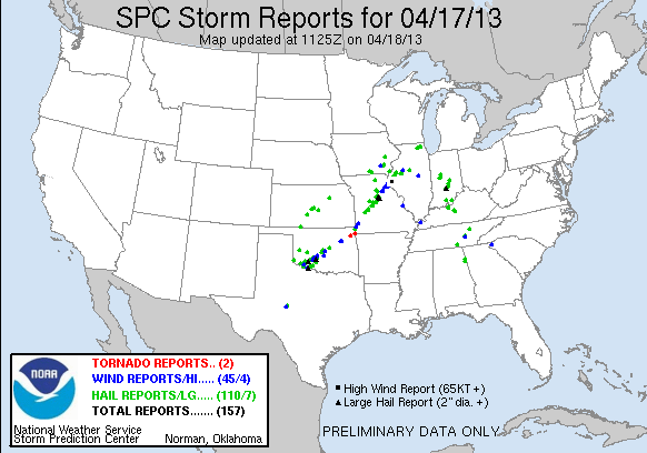
There were probably more tornadoes than the two being reported in Mayes and
Delaware counties. The twister that hit Lawton is conspicuously missing there.
But, these are only the reports that make it into the Local Storm Reports from
the NWS, which is not a comprehensive list.
Rains of 2-7 inches up and down the I-44 corridor caused localized flooding in
Medicine Park, Lawton, Chickasha, Newcastle, Norman, Oklahoma City, Shawnee,
Bixby and Kansas, to name a few. Anywhere along that line of training storms
probably had some flooding problems. River flooding is occurring along the
Little River near Tecumseh, the North Canadian in Oklahoma City, a broad
area in Wagoner, Tulsa, Okmulgee, Okfuskee, Muskogee and Creek counties, the
Neosho River near Commerce, and finally another broad area of Wagoner, Rogers,
Muskogee, Mayes, Delaware and Cherokee counties.
-------------------------------------------------------------------------------
Oh yeah, the new drought map!
Remember, this drought map from the U.S. Drought Monitor takes into account
rains up until Tuesday, so in reality this is a reflection of last week's
rainfall, as well as a bit of momentum from earlier rains.
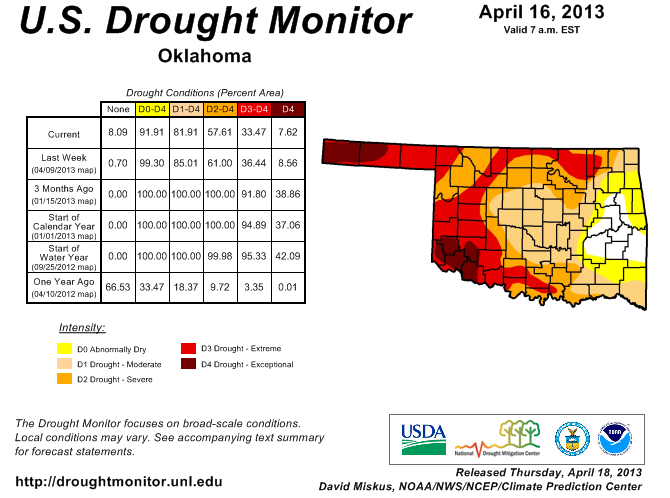
We now have 19% of the state free of drought, and 8% without any dry designation.
We're not quite to where we were last year at this time, but we're definitely
making some headway. All we need is for the rainfall to continue.
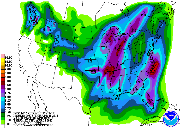
Don't look now, but another strong storm looks possible for early next week,
ANNNNDDDDD, another idiotic display of cold weather from Mother Nature. The
rains show up on the latest rainfall forecasts from WPC. Looks like northern
Oklahoma might finally get a dose after being shut out this go-round.
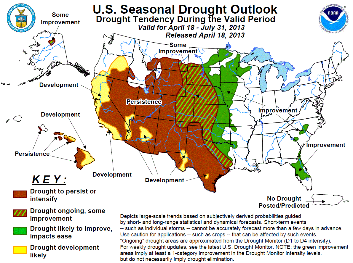
The new U.S. Seasonal Drought Outlook from CPC, released this morning, still
has most of the state in those "Some Improvement" or "Improvement" categories,
with only the Panhandle in the persistence/intensification categories. This
map is good through July.
-------------------------------------------------------------------------------
Record cold tomorrow
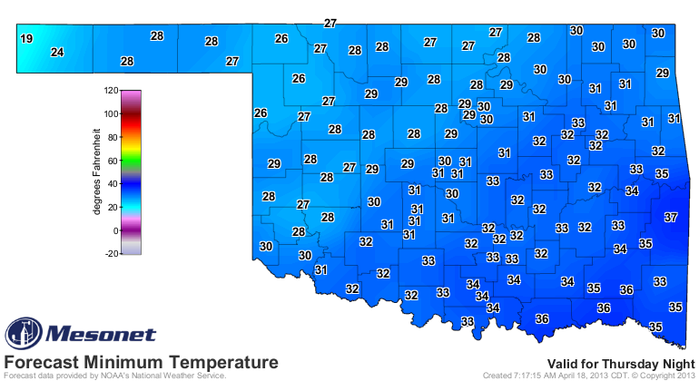
If these forecast lows occur tomorrow morning, we'll see lots of records broken.
Highs today might break records for LOWEST maximum temperatures for this date
in history. Here are those records for the day, dating back to the late 1880s.
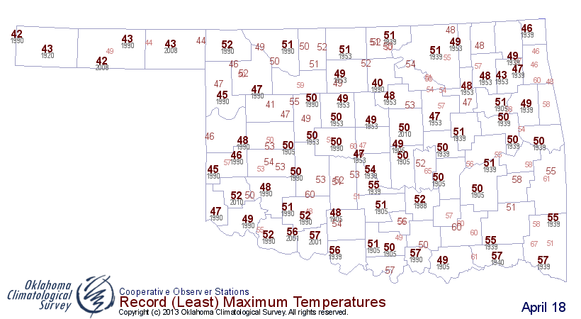
Keep your eye on those max temps from the Mesonet today across the NW half of
the state. Those records could fall.
http://www.mesonet.org/index.php/weather/map/todays_maximum_temps/air_temperature
Gary McManus
Associate State Climatologist
Oklahoma Climatological Survey
(405) 325-2253
gmcmanus@mesonet.org
April 18 in Mesonet History
| Record | Value | Station | Year |
|---|---|---|---|
| Maximum Temperature | 101°F | ALTU | 2011 |
| Minimum Temperature | 22°F | BOIS | 2013 |
| Maximum Rainfall | 3.17″ | TAHL | 2009 |
Mesonet records begin in 1994.
Search by Date
If you're a bit off, don't worry, because just like horseshoes, “almost” counts on the Ticker website!