Ticker for April 22, 2013
MESONET TICKER ... MESONET TICKER ... MESONET TICKER ... MESONET TICKER ...
April 22, 2013 April 22, 2013 April 22, 2013 April 22, 2013
Don't drought me, bro!
When I send my missives to the U.S. Drought Monitor today, I'm going to say "Hey,
we need improvements here and there and whatnot, what can you do for me?" Working
with a map like this
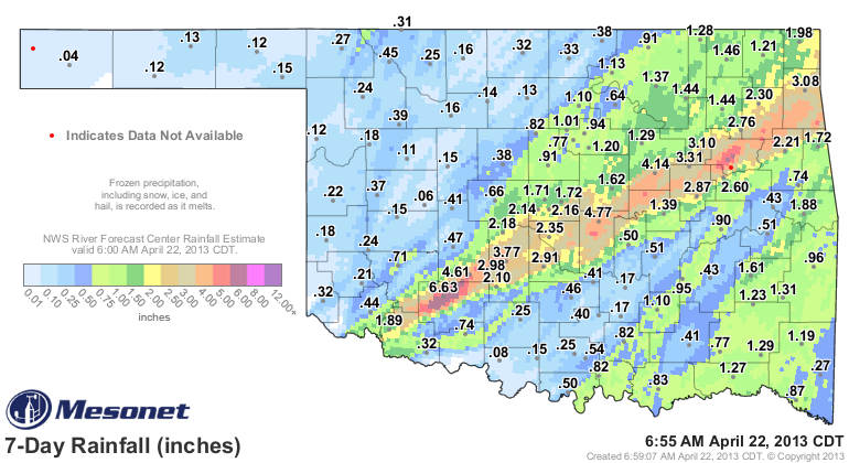
there's obviously something to work with. Taking a quick glance at our rainfall
statistics now shows some really inspiring news for the year thus far, mostly
due to February and the first three weeks of April. Check them out for yourselves.
And if you wonder why we're still seeing some drought after all these recent
rains, well, I'll throw the long-term stuff in there as well. These maps are
all from the Oklahoma Mesonet.
-***-
Period Statewide Avg. Dep. from Norm. Rank Since 1921
Apr 1-21 3.37" +1.04" 12th Wettest
Feb 1-Apr 21 7.94" +0.77" 15th Wettest
Jan 1-Apr 21 9.55" +0.89" 16th Wettest
May 1, 2012-Apr 21 23.01" -12.55" 3rd Driest
-****-
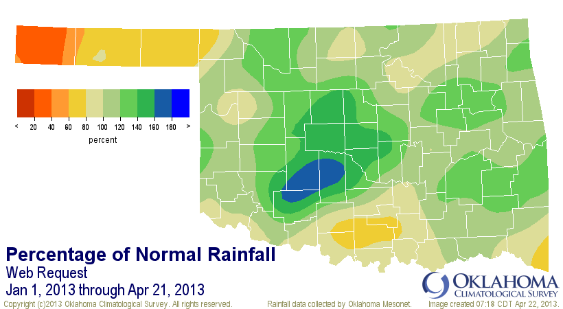
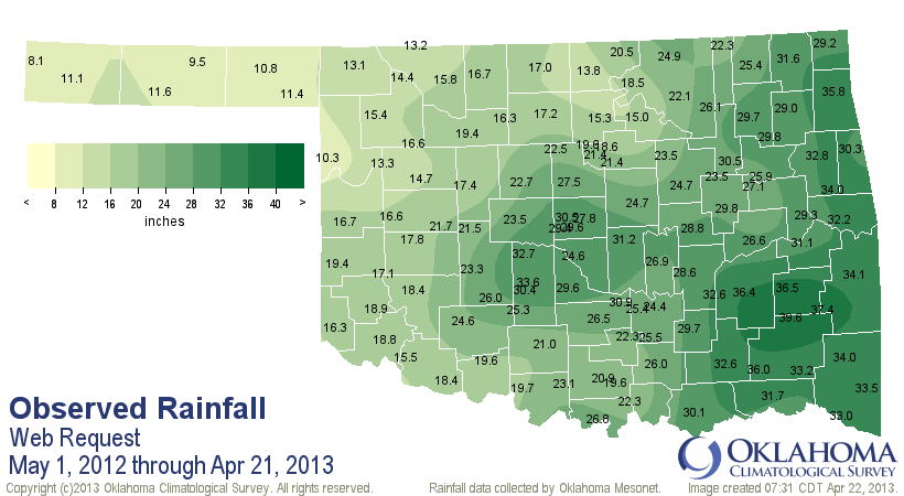
For those like me that do better with pictures, here's another chance.
Apr 1-21, 2013


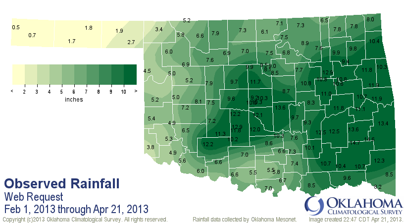
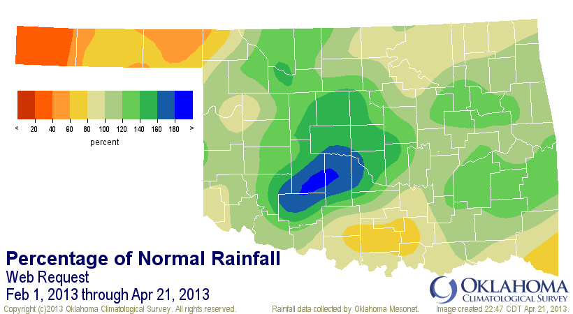
Feb 1-Apr 21, 2013
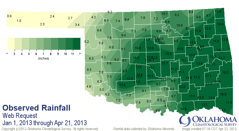
Jan 1-Apr 21, 2013
May 1, 2012-Apr 21, 2013
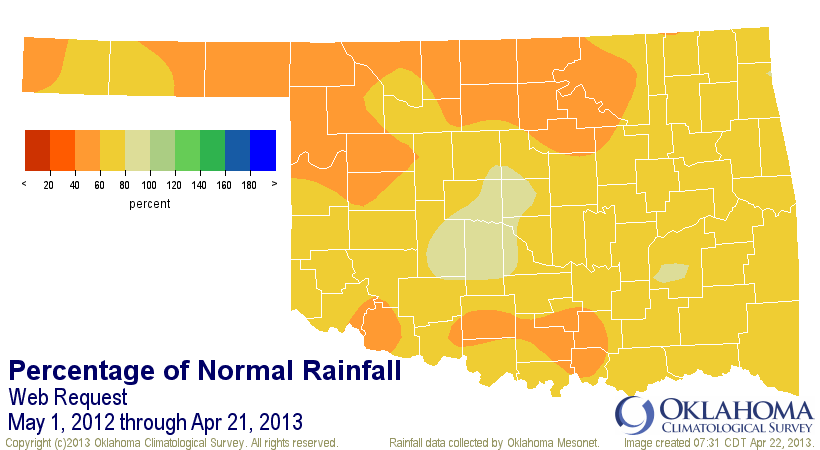
So there is obviously a disconnect between the great rains from east central
through central Oklahoma versus far western Oklahoma and along the northern and
southern fringes. Many of the short-term impacts we've seen have been quite
relieved over the last three months. Topsoil moisture, for instance.

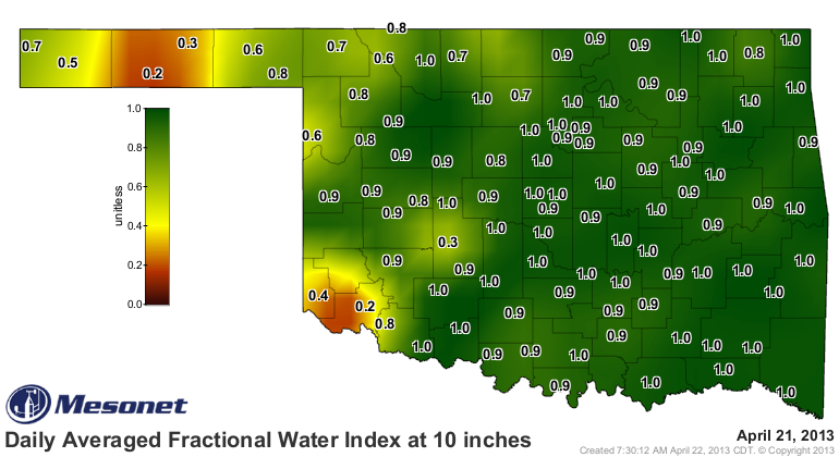
The moisture at lower depths, more of a long-term impact, just depends on where
you are. Some of it is very moist, and some of it is still very dry (from the
Arkansas-Red Basin River Forecast Center in Tulsa).
http://www.srh.noaa.gov/abrfc/?n=lower_an
Another long-term impact, the status of Oklahoma's lakes and reservoirs, has
improved dramatically across eastern Oklahoma and actually worsened in some
lakes in western Oklahoma. Note: Canton's elevation is a combination of
drought and water releases to OKC.

Quite a few lakes are ABOVE normal capacity into the flood pool. That's a great
cushion for any possible dryness coming up. However, also note that last column
I threw in there, the change from a year ago. Places like Altus and Tom Steed,
and even Oologah and Texoma, are much worse off than at this time a year ago.
In fact, 20 of the 27 lakes listed are either worse off or in about the same
condition at this time last year (May 2, 2012).
The key to NOT repeating that type of situation again this year is for the rains
to continue into spring this year, instead of the deficits we've seen from May
forward the in 2011 and 2012.
There are a couple more chances for rain this week, so that's a good sign it's
not ready to shut off just yet.
Just remember, some folks are still hurting from drought. They could use some
of that rain that has fallen across eastern and central Oklahoma over the last
few months. Until that happens, we're still all in this together.
Gary McManus
Associate State Climatologist
Oklahoma Climatological Survey
(405) 325-2253
gmcmanus@mesonet.org
April 22 in Mesonet History
| Record | Value | Station | Year |
|---|---|---|---|
| Maximum Temperature | 98°F | WALT | 2011 |
| Minimum Temperature | 25°F | EVAX | 2021 |
| Maximum Rainfall | 6.48 inches | MCAL | 1996 |
Mesonet records begin in 1994.
Search by Date
If you're a bit off, don't worry, because just like horseshoes, “almost” counts on the Ticker website!