Ticker for April 11, 2013
MESONET TICKER ... MESONET TICKER ... MESONET TICKER ... MESONET TICKER ...
April 11, 2013 April 11, 2013 April 11, 2013 April 11, 2013
Out darned drought
The amount of drought as indicated by the U.S. Drought Monitor decreased for the
second week in row, thanks to rains from the previous week. This week's rains will
not be considered until next week's map, so keep that in mind as you see this week's
version.
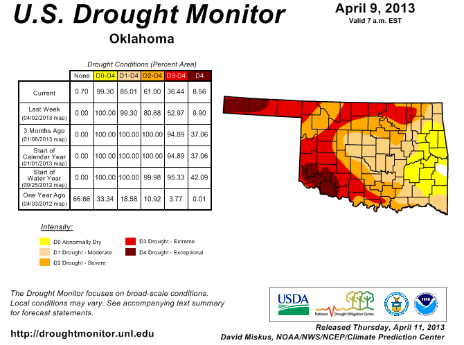
A large portion of east central Oklahoma is now drought free, with at least 15%
of the state considered in Abnormally Dry or with no designation. The Abnormally
Dry tag, or D0 on the scale, is used for an area that is dry but not in drought,
or for an area recovering from drought, so definitely the latter case in eastern
Oklahoma. That is the highest percentage of the state considered to be free of
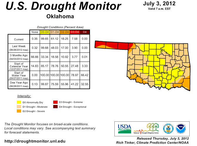
drought since July 3, 2012, when 33% was in the D0 or no category. One year ago,
67% of the state was drought free, but awaiting the ticking time bomb of the
driest May-December on record for Oklahoma.

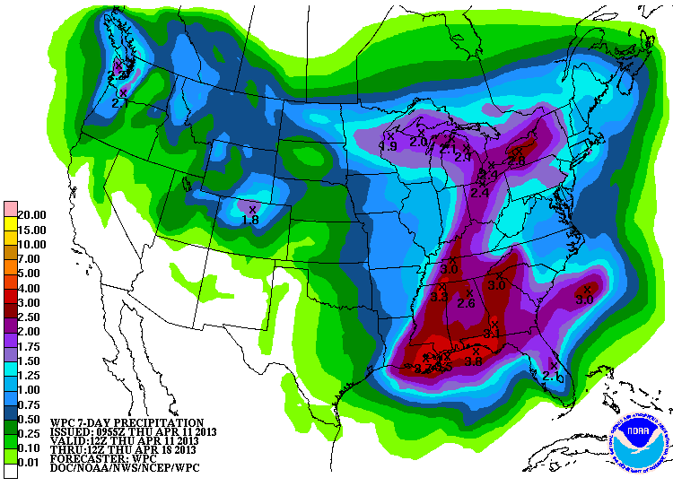
We will have to wait and see if the storm systems for the weekend and next week
pan out. As of now, looks like the state might see a half-inch to an inch. But
this map only extends through next Thursday morning, so these amounts could
go up.
It would be a great time to keep the momentum up, and hopefully carry it into
May and June this go-round, unlike the last two years. For a reminder on how
quickly drought can come back when we get to the warm season, check out the
rainfall maps from last April.
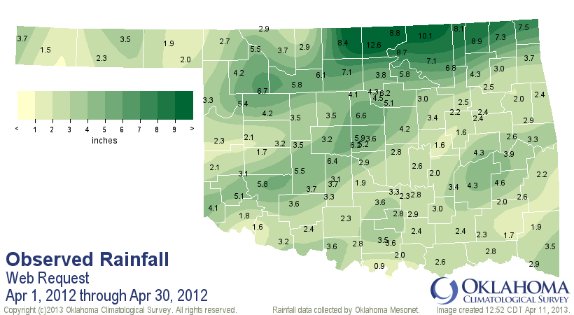

The northwestern half of the state still saw huge rains during April, and were
back in drought three months later.
-------------------------------------------------------------------------------
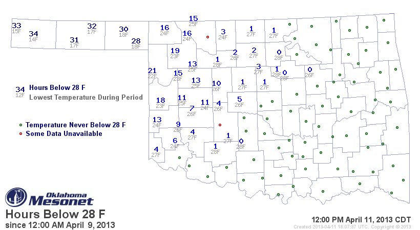
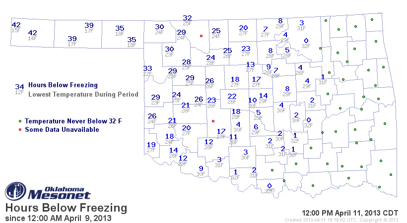
It's freezing in here!
No, literally. Or at least it was. More freezing weather last night, as shown
on the low temperature map from the Mesonet.
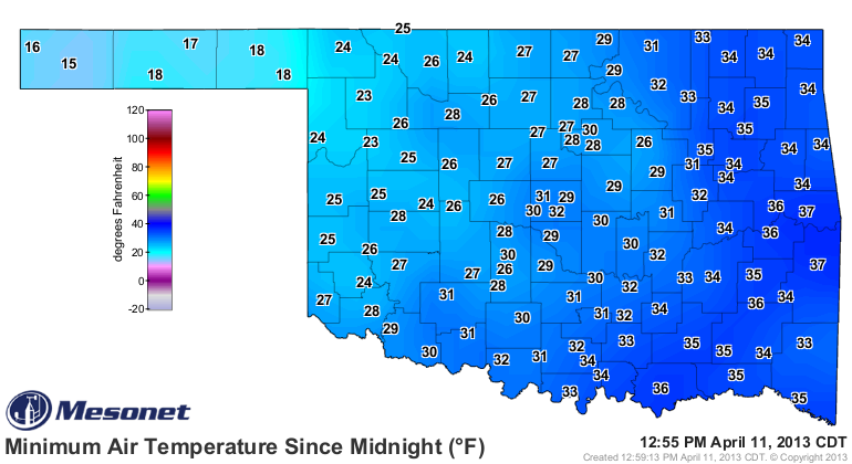
The 15 recorded at Boise City ties for the lowest temperature ever recorded
in the state on any April 11th, dating back to the 1880s. The other 15 was
recorded at Goodwell back in 1922. So quite cold out there last night! Here
are the hours below 32, 28 and 24 degrees for this event, as recorded by
the Mesonet.

As for how damaging this event was to wheat and other crops or plants, it is
apparently a waiting game. Up to a week will go by before the diagnosis is in.
Finally, how close was this type of weather (the below-freezing air or precip)
to being the latest on record for the state? Well, you have to go quite a ways
ahead to see the extreme of the extremes, and yes, it usually occurs up in the
Panhandle. This from a description of wintry weather of *MAYS* past, from former
Associate State Climatologist Howard Johnson.
That's right ... May.
"Major weather events not associated with thunderstorms include the
12-inch snowfall at Boise City on May 3, 1978, the 1-inch snowfall at
Kenton May 20-21, 1931, and the very late hard freezes in the northwest
on May 27 and 28, 1907 and around Kenton on May 29, 1947."
Enough talk of cold, however. We love the drought relief, but bring on spring!
Gary McManus
Associate State Climatologist
Oklahoma Climatological Survey
(405) 325-2253
gmcmanus@mesonet.org
April 11 in Mesonet History
| Record | Value | Station | Year |
|---|---|---|---|
| Maximum Temperature | 96°F | ARNE | 2018 |
| Minimum Temperature | 15°F | BOIS | 2013 |
| Maximum Rainfall | 4.55 inches | VINI | 1994 |
Mesonet records begin in 1994.
Search by Date
If you're a bit off, don't worry, because just like horseshoes, “almost” counts on the Ticker website!