Ticker for April 9, 2013
MESONET TICKER ... MESONET TICKER ... MESONET TICKER ... MESONET TICKER ...
April 9, 2013 April 9, 2013 April 9, 2013 April 9, 2013
Are you ready for summer, spring, and winter?
I thought about activating the "Bread and Milk Emergency Alert System," but after
you get hit by a tornado, your power will probably be off anyway and the milk
would spoil. And rubble is not good for bread ... tends to smash it. I jest, of
course, but Oklahoma is going to have one of "those" days that it is famous for,
with the possibility of highs close to 90, severe thunderstorms, tornadoes, hail,
sleet, heavy rain, snow, freezing rain, and drought (threw that last one in there
for kicks). This is all thanks to a powerful storm system sweeping into the state,
which will also drag a strong cold front through in its wake. So this is a good
day to be weather aware for several different hazards.
Instead of posting 10 different graphics from the local NWS offices, just take
a look at the Mesonet's local and regional forecast page. It grabs all the
graphics from the NWS and puts them in one place.
http://www.mesonet.org/index.php/forecast/local_and_regional
Be sure to visit their pages as well.
http://www.srh.noaa.gov/ama
http://www.srh.noaa.gov/oun
http://www.srh.noaa.gov/tsa
http://www.srh.noaa.gov/shv
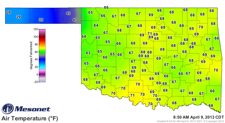
Speaking of that powerful cold front, THAR SHE BLOWS!! Check out the current
winds and temps from the Mesonet, with your gaze fixed on the Panhandle (where
it should always be fixed anyway).

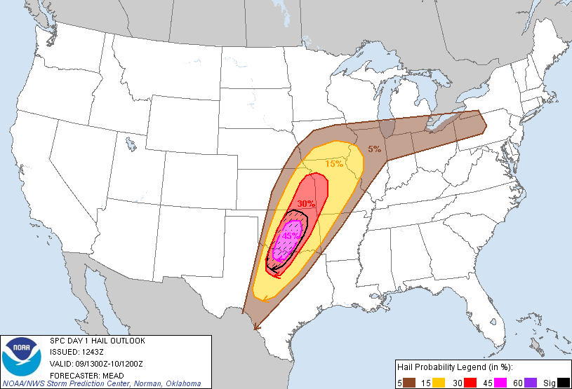
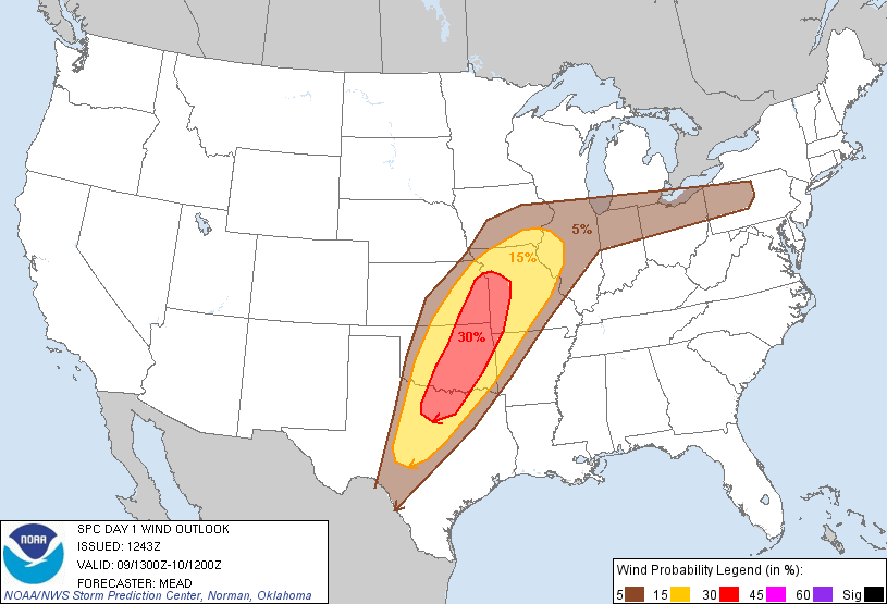
Right now this looks to be a wind/hail event, with some heavy rain thrown in
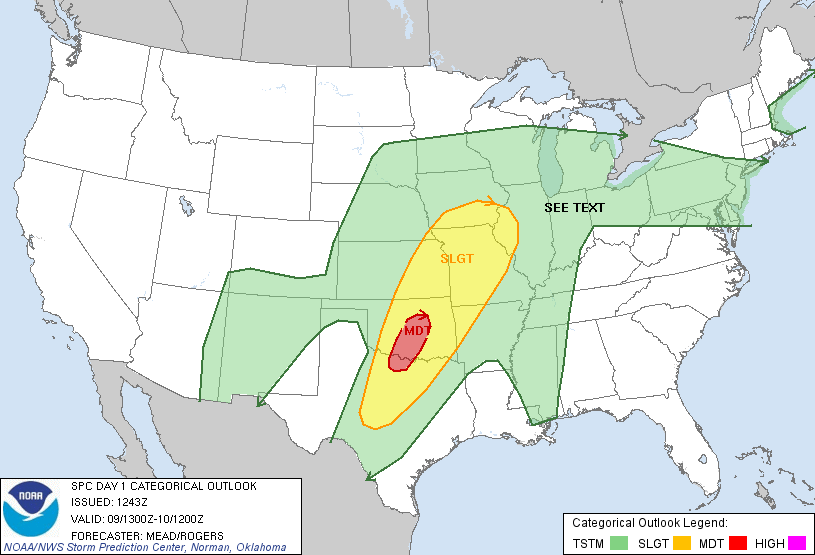
for good drought relief, I hope. Take a look at the Moderate risk area as it
stands now from the Storms Prediction Center, then you can see the categorical
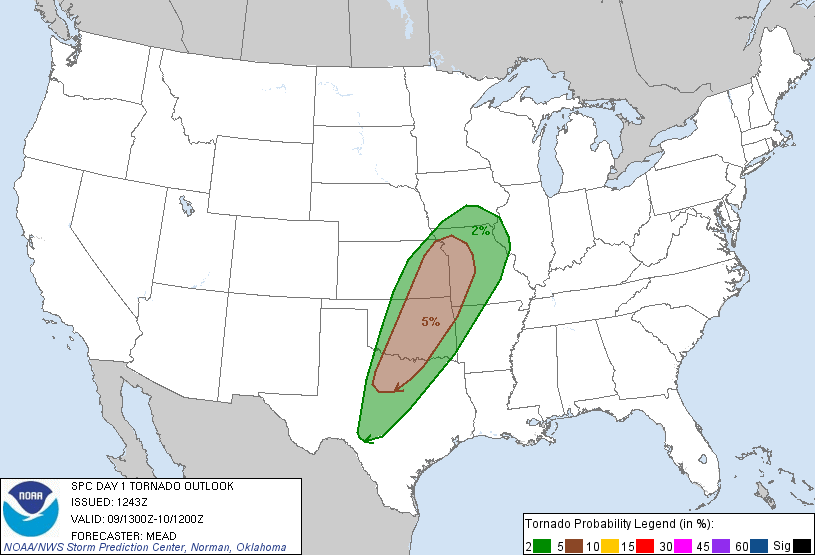
chances for each of the severe hazards. Tornado chances are low right now, but
that could definitely change, of course.
The best part of this is that a good part of the state has the possibility for
1-2 inches of rainfall with this squall line that should form and march across
the state.
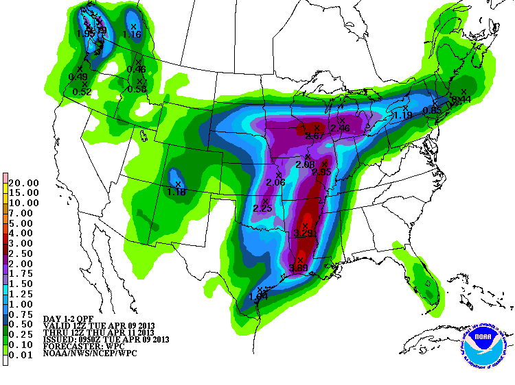
Convective rain falling on moist soils normally would equal lots of runoff, so
this is a chance to boost those lakes and farm ponds, hopefully. Western OK
might get left out a bit, unfortunately. And the temperatures being forecast
could drop low enough in places to see freeze damage to plants and crops.
The most important thing, however, is to deal with the severe weather first, and
that means staying weather aware. Pay attention to your local media (TV, radio,
the voices in your head) and NWS offices to stay up to date with what's happening,
because all of these graphics and maps I'm showing you this morning will change
throughout the day as the event evolves. You can follow the progression of the
front and find all the warnings and radars you need right on our Mesonet page
if you so wish.
http://www.mesonet.org/index.php/weather/category/advisories
http://www.mesonet.org/index.php/weather/category/radar
I don't advise doing what we are planning (hiding in a hole like a sniveling
coward). Just stay informed. It's severe weather. We're used to it.
WAIT! There could be fire danger too down in SW OK after the dryline passes
through.
Phew! About missed one.
Gary McManus
Associate State Climatologist
Oklahoma Climatological Survey
(405) 325-2253
gmcmanus@mesonet.org
April 9 in Mesonet History
| Record | Value | Station | Year |
|---|---|---|---|
| Maximum Temperature | 100°F | HOLL | 2011 |
| Minimum Temperature | 18°F | KENT | 2013 |
| Maximum Rainfall | 4.69 inches | GUTH | 2008 |
Mesonet records begin in 1994.
Search by Date
If you're a bit off, don't worry, because just like horseshoes, “almost” counts on the Ticker website!