Ticker for April 8, 2013
MESONET TICKER ... MESONET TICKER ... MESONET TICKER ... MESONET TICKER ...
April 8, 2013 April 8, 2013 April 8, 2013 April 8, 2013
The Good, the Bad, and the Fistfull of Damaged Wheat
Normally I'd be leading with the expected rains this week, since drought has been
taking body punches lately. But news from the wheat world was less than favorable
after the deep freeze experienced by the state a couple of weeks ago. Now comes
word from OSU SMall Grains Extension Specialist Dr. Jeff Edwards that the freeze
damage was worse than what they feared. Quoting Dr. Edwards from his "World of
Wheat" blog:
"On April 4th I toured southwest Oklahoma and surveyed freeze injury
to wheat. In my experience, most freeze events are overhyped; however,
this one was the real deal Holyfield. I traveled a route from Faxon
to Chattanooga to Altus to Blair and ended up at Apache. Damage was
similar at all sites, with injury ranging from 50 to 80%."
You can read more about the freeze injury to the 2013 wheat crop at his blog:
http://osuwheat.com/
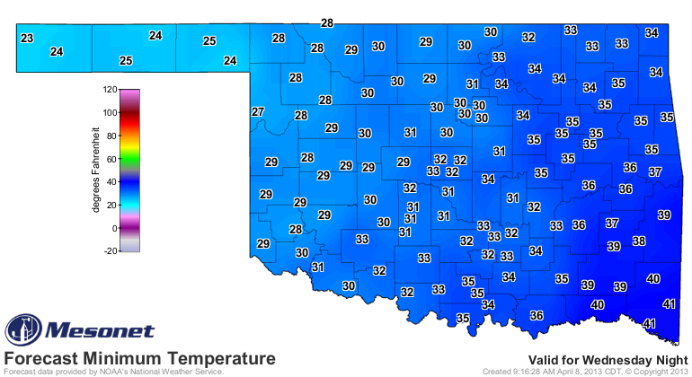
I mention this because it appears more freezing temperatures are likely. At this
time, our friends at the NWS are not predicting the teens and low 20s we saw
with that last freeze event, at least not in the main body of the state. Here
are the forecast maps from the Mesonet using the NWS forecast temperatures.
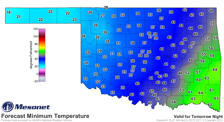

The mechanics and intricacies of freeze damage to wheat escapes me, but I do
understand it depends on how far along the wheat is at the time of the freeze.
So this complicates things with wheat planted late, delayed by the cooler than
normal weather, or delayed due to drought. It looks like from the current
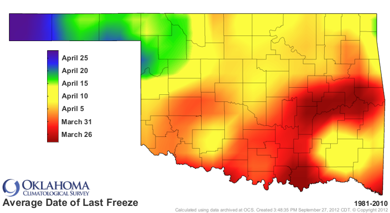
forecasts any wheat in advanced stages up in the far northwest might be in
jeopardy. However, we're still in the time frame of the normal climatological
last freeze date in that region, so maybe the plants up there are used to this
late of a freeze. Of course, 32 degrees is far different from the 24-26 degrees
they're looking at this week.
-------------------------------------------------------------------------------
Send rain, hold the tornadoes
A powerful storm system will bring rain to the state this week, and also the
chance of severe weather. Lots of "ifs and buts" with this system when it comes
to severe weather, particularly for the chance of tornadoes. But as we've
mentioned many times, it's tough to get rain in the spring without a healthy
does of hail, severe winds and the occasional twister. Here are the latest
rainfall totals being forecast by the WPC.
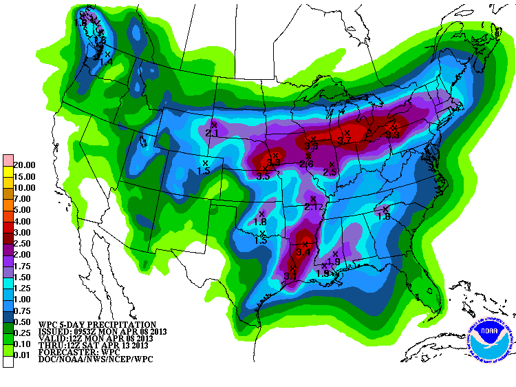
Another 1-2 inches across the eastern two-thirds of the state would hit the
spot quite nicely. When it comes to convection, however, things get pretty
tricky. So we'll just have to wait and see where squall lines form, and where
we might see storms forming and training repeatedly over the same area (or if
that occurs at all). The totals could shift east and west quite a bit. As usual,
more looks likely for eastern Oklahoma. That's reflected in the graphics from
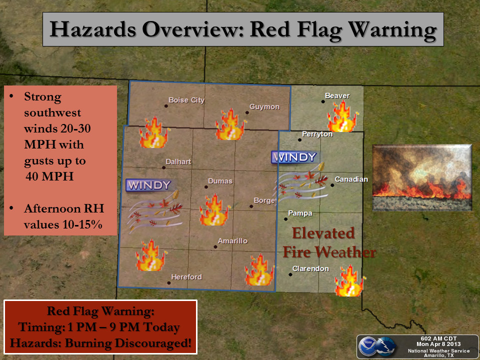
the NWS offices that serve our state ... severe weather updates from Tulsa and
Norman, and fire weather concerns from Amarillo for the Panhandle.
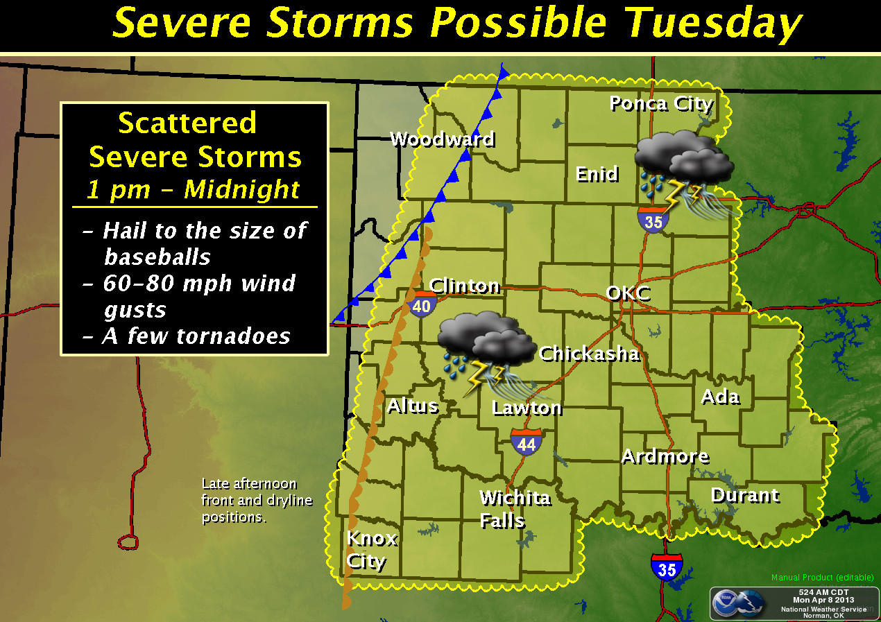
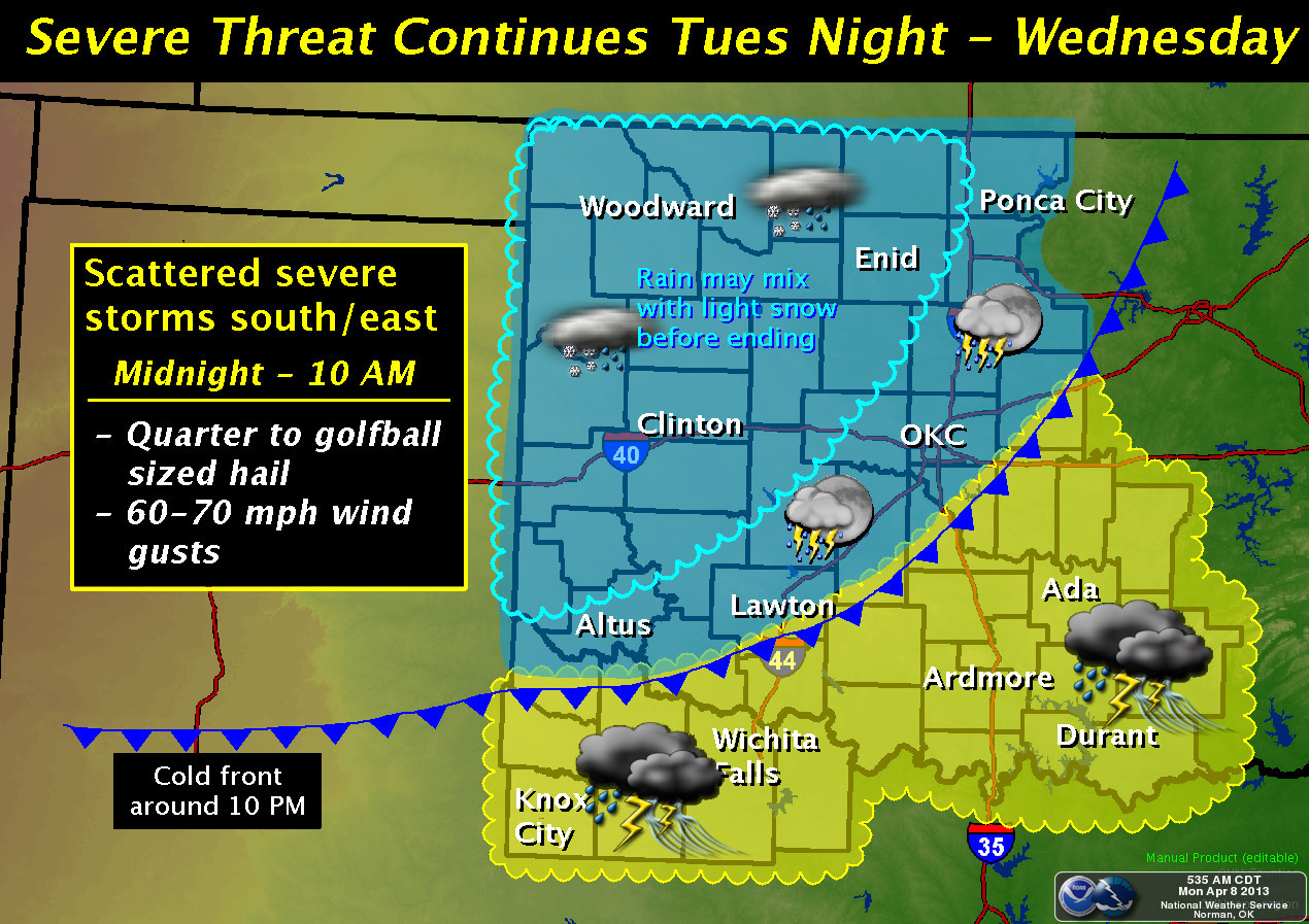
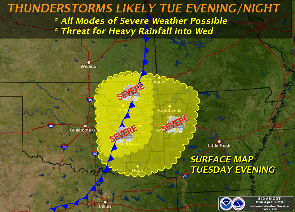
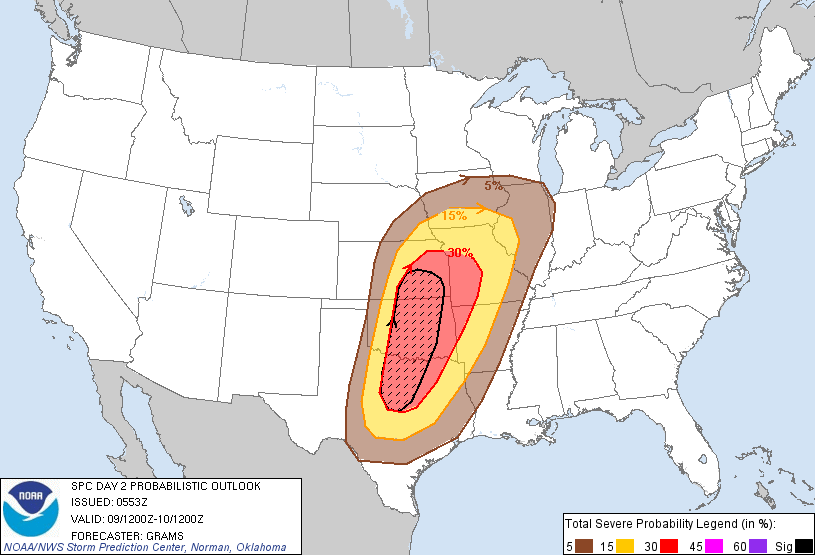
Tuesday appears to be the big day, so stay glued to the TV and the various NWS
office pages so no surprised crop up. Here is the severe weather probability
map from the Storms Prediction Center.
Meteorologists see tornadoes and whatnot, I see drought relief. I hope the latter
comes without the former.
Gary McManus
Associate State Climatologist
Oklahoma Climatological Survey
(405) 325-2253
gmcmanus@mesonet.org
April 8 in Mesonet History
| Record | Value | Station | Year |
|---|---|---|---|
| Maximum Temperature | 96°F | MANG | 2020 |
| Minimum Temperature | 17°F | JAYX | 2007 |
| Maximum Rainfall | 3.22 inches | BIXB | 2008 |
Mesonet records begin in 1994.
Search by Date
If you're a bit off, don't worry, because just like horseshoes, “almost” counts on the Ticker website!