Ticker for April 4, 2013
MESONET TICKER ... MESONET TICKER ... MESONET TICKER ... MESONET TICKER ...
April 4, 2013 April 4, 2013 April 4, 2013 April 4, 2013
A simple recipe
Drought is actually a pretty complicated hazard. A boring one, but complicated.
There are so many different sectors of the economy and society that it can strike,
pinning a drought severity down takes a lot of work in some cases. What's simple,
however, is the recipe for drought relief.
Rain.
And we had a nice combination of intense, runoff-style gully washers and also some
slow-to-moderate soil soakers over the last four days. Let's take a look at the
final storm totals for this system from the Oklahoma Mesonet, with the radar
estimates thrown on top. We'll use the 5-day map to make sure we capture all of
the little stuff (a few locations need that little stuff).

Here you can see the classic signature of a stalled frontal system with warm,
moist air running over the top of it and dropping its water over a large area.
But also concentrated along a common axis. In this case, from Custer and Washita
counties in west central Oklahoma to Leflore County in the southeast. Rainfall
totals within that band range from 2-6 inches. As would be expected, the totals
diminish as you go farther to the north and south from that area.
Here are the top-20 rainfall totals from the current system:
-***-
Talihina 5.61" Ninnekah 3.62"
Clayton 5.32" Bowlegs 3.56"
Minco 4.21" Holdenville 3.51"
Chickasha 4.15" Stuart 3.43"
Byars 4.04" Wilburton 3.30"
Norman 3.98" Wister 3.25"
Washington 3.94" OKC East 3.14"
McAlester 3.93" El Reno 3.03"
Shawnee 3.92" Guthrie 3.03"
Pauls Valley 3.85" Eufaula 3.02"
-****-
As usual, let's give our thoughts to those still in need ... namely far western
Oklahoma and the Panhandle. Their totals of a half-inch or less were welcome,
but also disappointing. Their drought impacts were hardly relieved, and will
continue unabated. That's the same story for the entirety of this 2.5-year
drought period. The eastern two-thirds of the state have now seen two very
distinct periods of relief, while far western Oklahoma and the Panhandle have
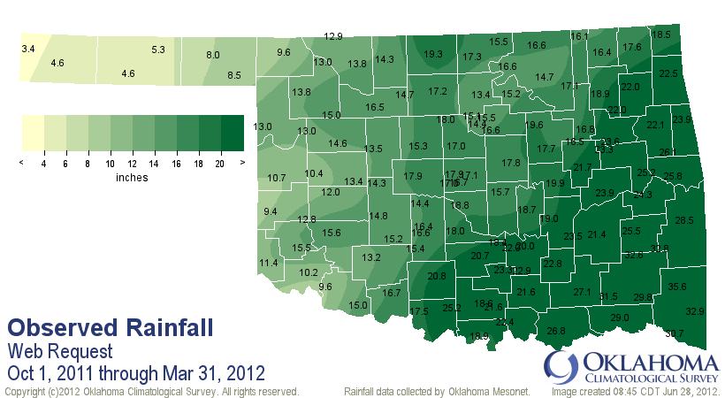
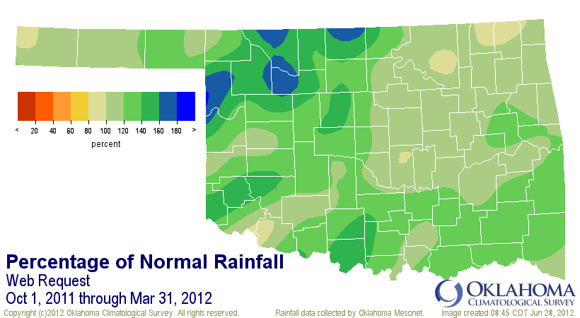
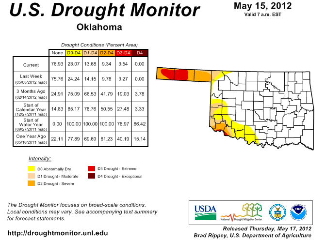
generally missed out. The first period of relief was the October 2011-March
2012 version. Here are the rainfall maps for that span, and the Drought Monitor
map that resulted.
The second is obviously what has occurred over the last three months. Here are
the maps for the Jan. 1-April 4 span, as well as the beginning drought map.
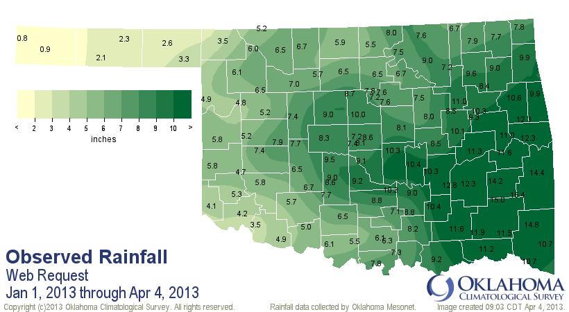
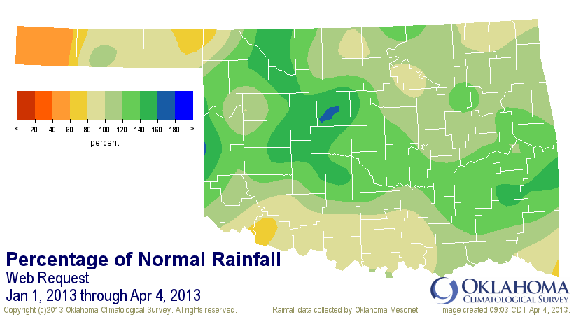
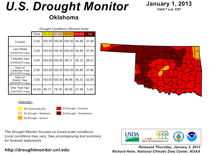
That includes an "okay" January, moisture wise, a great February, a dud of a
March, and a great first few days of April. Now I will show you the newest
drought map released this morning, but keep in mind that most of the last few
days of rain are not considered in its depiction. Tuesday morning at 7am is the
cutoff point. That is necessary because the national author is trying to do this
for 50 states, as well as Puerto Rico. Here is the map.
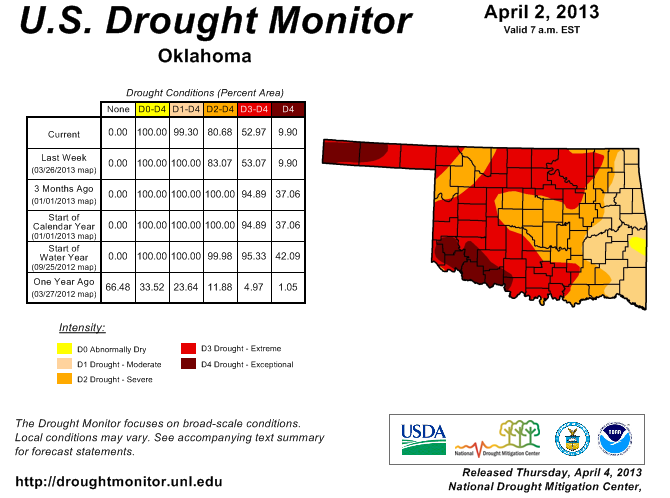
That map didn't change too much from last week, but there is one significant
change nonetheless. Check out that weird yellow color in LeFlore County ...
abnormally dry? That's what the DM uses when somebody is dry, but not quite in
drought, either just heading in or coming out of drought. That's actually the
first time we've seen a part of the state out of drought since July 2012! Now
watch for next week's map because you will see some pretty big changes due to
this week's rains.
Here's another great change from what we've seen over the last 9-10 months. Take
a gander at the latest U.S. Seasonal Drought Outlook. Most of Oklahoma is
included in the "drought likely to improve" or "drought ongoing, some
improvement" area for April 4-June 30.
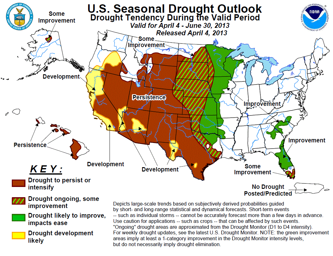
Unfortunately, the Panhandle remains in the "drought to persist or intensify"
area. I actually asked to have that line moved about a county to the east into
far western Oklahoma, but they didn't bite. But this product isn't really
supposed to be county-by-county ... more of a fuzzy line between depictions.
While warm season rainfall can be pretty tough to forecast, especially with no
large-scale climate drivers in place (El Nino, La Nina, etc.), it is spring and
there's not really a good reason to predict below normal rainfall for the next
few months. With soil moisture recovering, that will add a boost to the chances.
Drought is still in place at varying degrees of intensity across the western
two-thirds of the state, of course. But it ain't the big bad monster of a few
months ago for a lot of areas now.
Looking ahead at next week's possible storm, more relief is in store for the
state ... especially eastern Oklahoma once again. We'll see how it shapes up.
For now, we'll rest on the laurels of the latest rainfall.
Gary McManus
Associate State Climatologist
Oklahoma Climatological Survey
(405) 325-2253
gmcmanus@mesonet.org
April 4 in Mesonet History
| Record | Value | Station | Year |
|---|---|---|---|
| Maximum Temperature | 94°F | ALTU | 2023 |
| Minimum Temperature | 16°F | BUFF | 2018 |
| Maximum Rainfall | 4.31 inches | TALI | 2025 |
Mesonet records begin in 1994.
Search by Date
If you're a bit off, don't worry, because just like horseshoes, “almost” counts on the Ticker website!