Ticker for April 3, 2013
MESONET TICKER ... MESONET TICKER ... MESONET TICKER ... MESONET TICKER ...
April 3, 2013 April 3, 2013 April 3, 2013 April 3, 2013
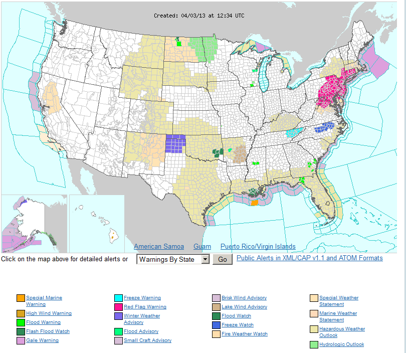
Flood watch in the house!
The Panhandle gets the Winter Weather Advisory and eastern Oklahoma gets the
flood watches. The times, they are a changing.
I think the Panhandle would like to transfer a little of that rain over there,
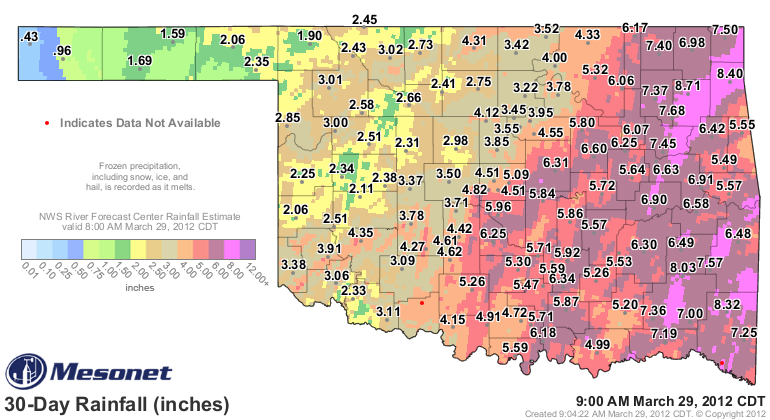
and southeastern Oklahoma now has plenty to spare. Check out these rain totals
from the Mesonet and the RFC's radar-gauge estimates overlay from the last five
days.
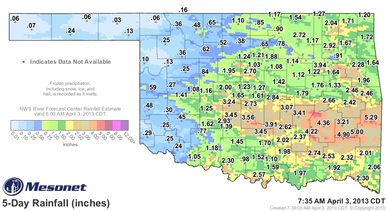
And, RAIN IS STILL FALLING!
Those areas showing flood watches are naturally the places that have received the
most. With moist soils and streams topping their banks, those low lying areas
will need to be avoided.
This has been a whopper of a storm system so far, one of the wettest we've seen
during this 2.5 year drought cycle. Unless you live in the western one-third
of the state. Not so much of a whopper for those folks just yet. The biggie
during the drought was still the deluge from March 19-22nd of 2012.
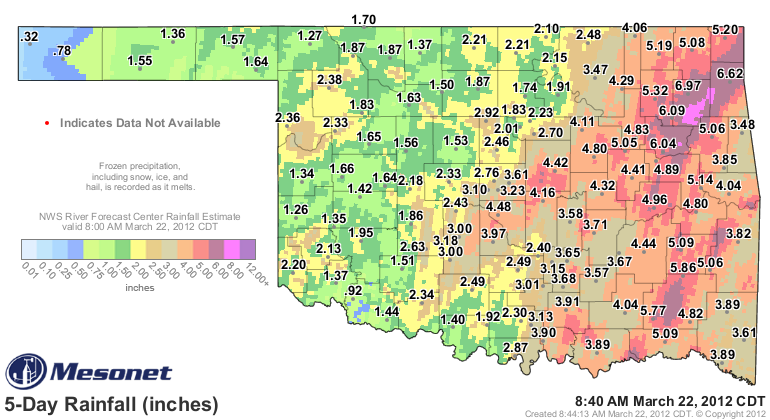
That was a 4-day event, basically, so while this one hasn't quite matched it
yet ... another couple of expected storm systems could pull them even. Remember
where we were last year at this time ... drought was shrinking and on its way
out after a ridiculously wet March.
Here's the Drought Monitor map from a year ago.

We'll ignore that we lived through the driest May-December on record for
Oklahoma just a few months after that for the sake of positivity.
I really do believe for much of central and eastern Oklahoma, we are on our
way to a map like that. Not so much for the western parts of the state just
yet, but with this active pattern, there is at least hope the relief will
spread to the west.
Outlooks like this for next week are certainly encouraging.
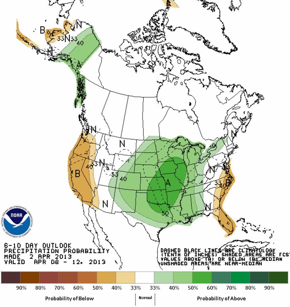
As are the actual rain total forecasts.
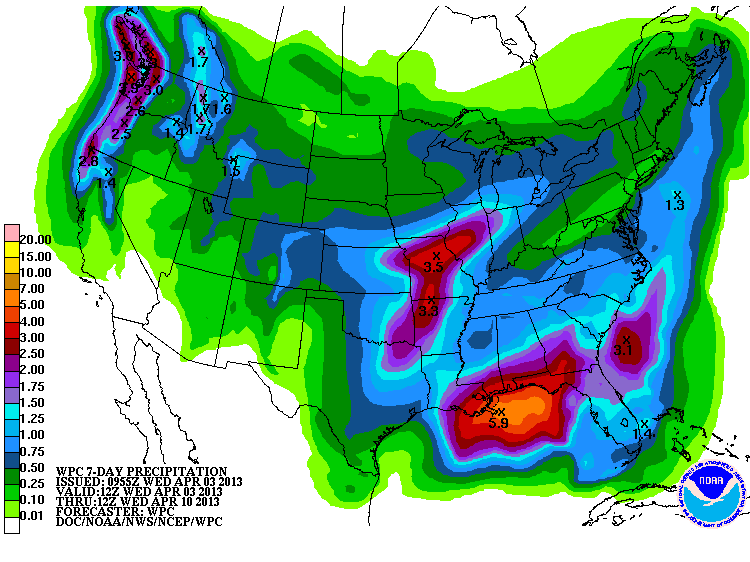
Those maps spell continued drought for western Oklahoma and drought relief (dare
I say "eradication") for eastern Oklahoma. Springtime rainfall is very difficult
to forecast, however, since it generally comes from convection. It's very
difficult to predict too far in advance where those squall lines will form, or
where storms might train repeatedly over the same area.
So don't give up hope, western Oklahoma. My drought talk in Woodward yesterday
was met with drizzle and fog, but your turn may come soon. It was only about
a month ago you were dealing with several feet of snow, after all.
Gary McManus
Associate State Climatologist
Oklahoma Climatological Survey
(405) 325-2253
gmcmanus@mesonet.org
April 3 in Mesonet History
| Record | Value | Station | Year |
|---|---|---|---|
| Maximum Temperature | 103°F | ALTU | 2011 |
| Minimum Temperature | 15°F | KENT | 2002 |
| Maximum Rainfall | 3.12 inches | WAUR | 2012 |
Mesonet records begin in 1994.
Search by Date
If you're a bit off, don't worry, because just like horseshoes, “almost” counts on the Ticker website!