Ticker for April 1, 2013
MESONET TICKER ... MESONET TICKER ... MESONET TICKER ... MESONET TICKER ...
April 1, 2013 April 1, 2013 April 1, 2013 April 1, 2013
Could drought be on its way out?
Here comes the rain!
No, this is not an April Fool's joke. I already reached my limit of one today ...
I showed the top of my head a picture of a comb. What I'm talking about is rain,
and apparently lots of it. I'm often accused of being a negative Nellie, which is
odd, since I'm usually very positive that things are half full. But I tend to
give what Mother Nature offers me. For the last 2.5 years, that's been drought
and heat, and lots of it. First off, March ended drier than normal, obviously.
You can read more about March down the page a bit. Let's start with the good
news. The latest precip total prediction from the WPC over the next few days shows
quite a bounty for Oklahoma.
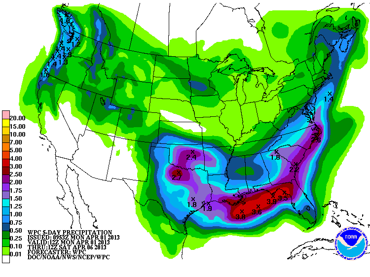
Wow! That looks pretty awesome to me ... 1-3 inches across most of the state. And
this isn't one of those 7-day out deals this time either. This is for the next
few days. This comes just at the nick of time, too, since we have turned dry
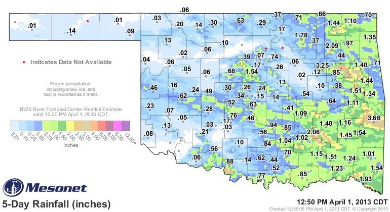
again. The state did see a round of springtime weather finally last weekend,
complete with drifts of hail in some parts and an actual confirmed tornado. The
rain was enough across parts of central and most of eastern Oklahoma to prime the
pumps for this next system.
Following this next storm system, there appears to be more on the way for next
week as well. Now that is one of those 7-day out deals, but it does appear to
be an active weather pattern. It's tough to get out of a drought with an
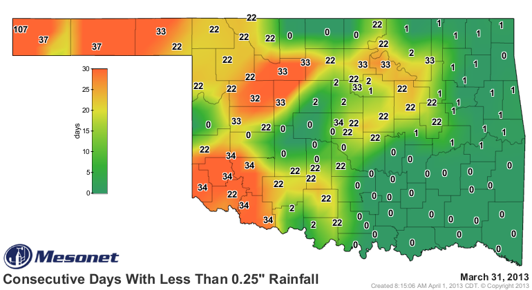
inactive one. Here's our starting point ... more than 30 days since much of
western Oklahoma has seen a quarter-inch of rain in a single day. If'n you're
talking the western Panhandle, take it back 107 days.
Now, I see no reason in the broad scope of things why we can't return to normal
rainfall this spring. If we can get this 2-4 inches across the state through
the first two weeks of April, that normal rainfall after that might be enough
to get us through the summer.
Tell me where I'm wrong, negative Nellies!
-------------------------------------------------------------------------------
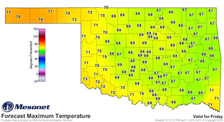
It's too hot, I mean too cold. I MEAN TOO HOT!
Mother Nature is on a roller coaster for awhile, and apparently she's been
taking the steroids again. After highs on Saturday in the 70s and 80s, a front
plunging through the state (PROOF!)
will drop temperatures back into February territory
before whizzing back to spring by the end of the week!
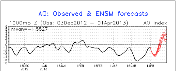
The Arctic Oscillation (AO) index is finally headed solidly back to positive
territory, meaning we should be on the mild-to-warm side for a couple of weeks
following our brief plunge back to winter.
Remember, negative AO signals a weakness in the jet, meaning kinks can happen.
Positive AO and the jet strengthens and the kinks tend to straighten out,
keeping that arctic air where it belongs. It can only be forecast about two
weeks out, but it looks good through that period. Notice how it was negative
since mid-February.
-------------------------------------------------------------------------------
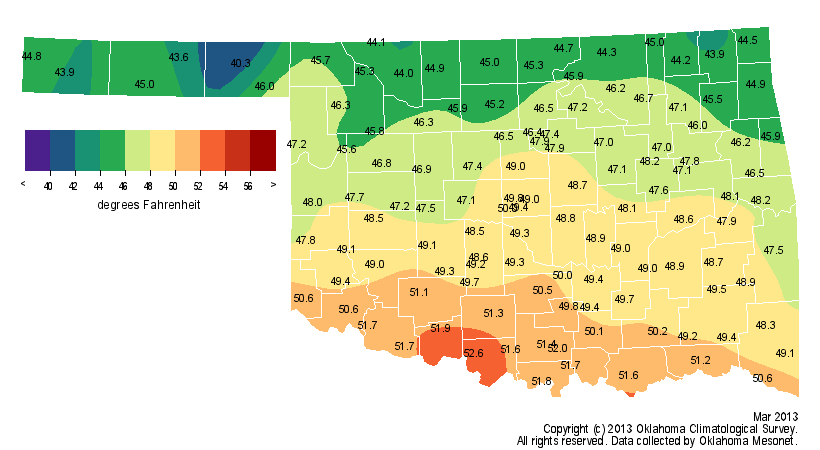
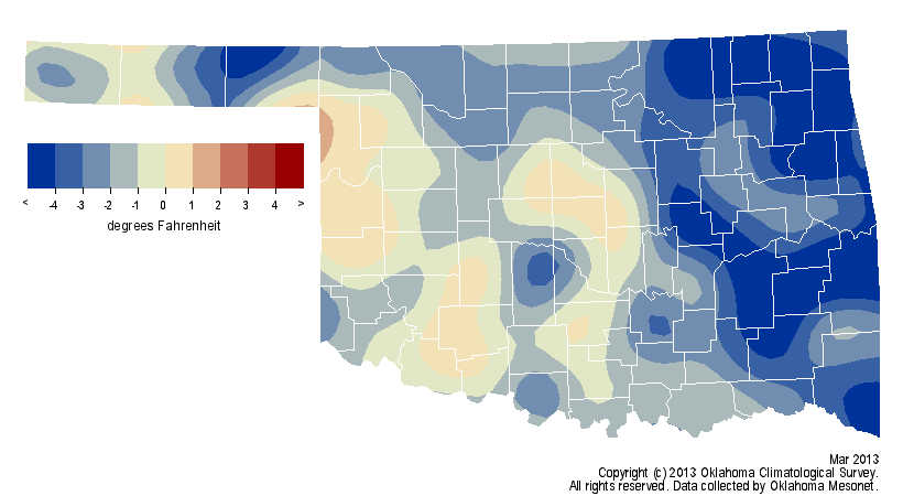
Arrival Of Spring Fails To Rescue Dry March
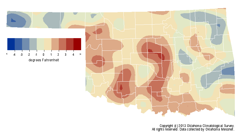
The wet conditions of February failed to translate into March, but the cooler
than normal weather continued virtually uninterrupted. According to data from
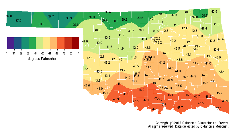
the Oklahoma Mesonet, the month's statewide average temperature was 47.7
degrees, 2.5 degrees below normal and the 45th coolest March since records
began in 1895.
The two months together accomplished a relatively rare feat of late, becoming
the first consecutive months to finish below normal in Oklahoma since January
and February 2011.
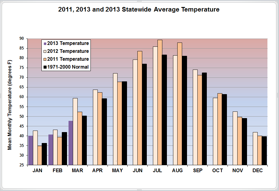
This March stands in stark contrast to last year's record-breaking version,
which ended at 59.6 degrees, 9.4 degrees above normal. Thanks to a late-month
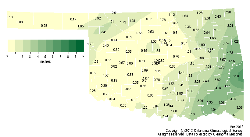
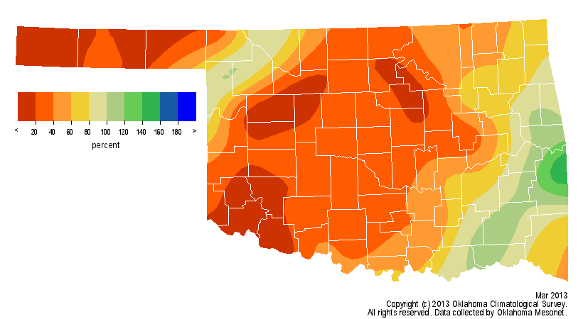
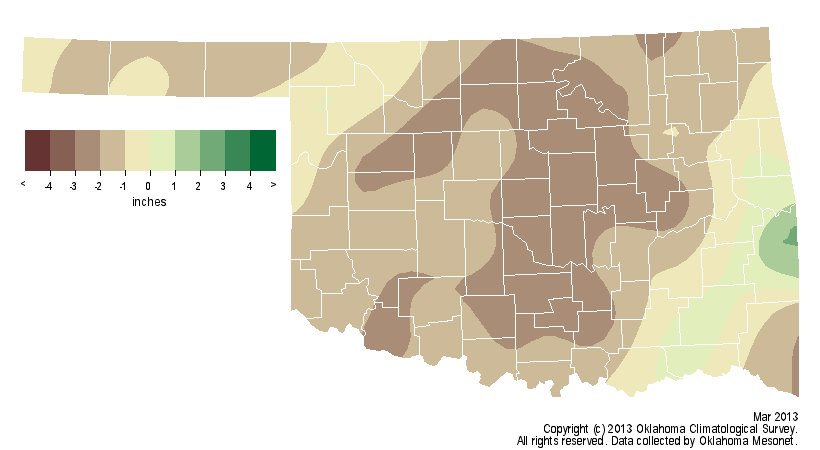
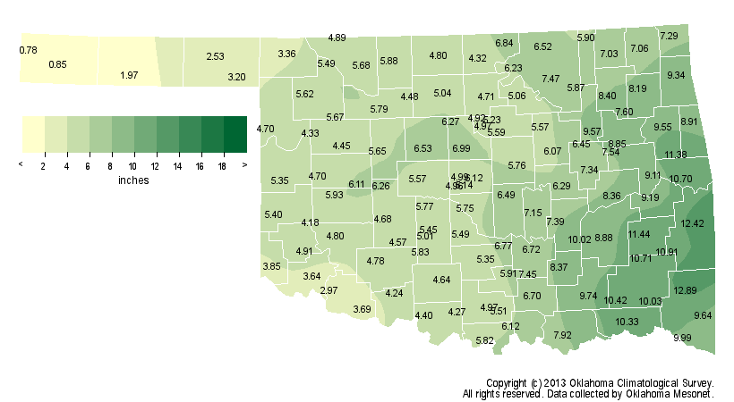
taste of spring storminess, the statewide average rainfall total climbed to 1.5
inches for the month, which fell about 1.6 inches below normal and ranked as
the 33th driest on record.
The first three months of the year came out fairly close to normal for both
precipitation and temperature. The statewide average January-March temperature
finished at 42.8 degrees, a tenth of a degree above normal, while the
precipitation total of 6.44 inches was a tenth of an in above normal as well.
That late burst of springtime weather also came with a fair amount of severe
weather. Reports of hail from the size of marbles to tennis balls came in from
across the state on the 29th and 30th. Hail covered the ground and actually
drifted in some parts of the state. At least one tornado was confirmed to have
touched down late on the 30th in Sequoyah County near Sallisaw, damaging a
home and downing power poles. More localized severe weather struck southern
Oklahoma on the ninth and northern Oklahoma saw up to 3 inches of snow on the
24th.
The cooler than normal weather kept drought from spreading or intensifying,
although drought impacts continued to be felt statewide. Data from the USDA's
National Agricultural Statistics Service indicate 49 percent of the state?s
topsoils were rated as either "adequate" or "surplus" for moisture, meaning 51
percent were rated as "short" or "very short." Subsoils have not fared quite
so well given the long-term nature of this drought. The subsoils were rated at
88 percent "short" or "very short" and only 12 percent were rated as
"adequate." State pasture and range conditions were rated 70 percent "very
poor" or "poor," with only 25 percent rated as "fair" and 5 percent rated as
"good."
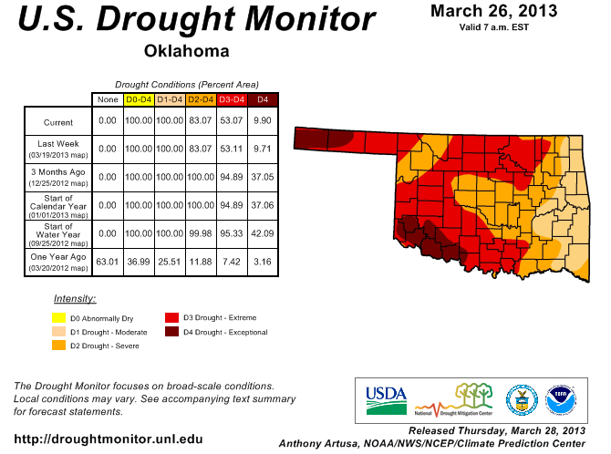
Approximately 10 percent of the state was covered by Exceptional drought
according to the latest U.S. Drought Monitor report, down from 35 percent
three months ago. The entire state has remained in at least Moderate drought
since July 2012. The Drought Monitor?s intensity scale slides from Moderate-
Severe-Extreme-Exceptional, with exceptional being the worst category.
A very active weather pattern appears possible during the first two weeks of
April, which could bring further drought relief. Short- to medium-range
forecast models indicate the potential for 2-4 inches of rainfall across the
state during the first two weeks of the month. The April precipitation outlook
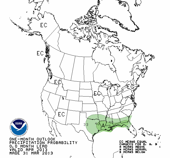
from the National Weather Service's Climate Prediction Center showed increased
odds of above normal precipitation across the southeastern third of the state.
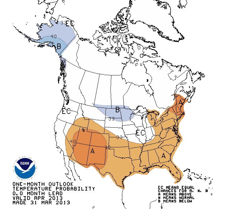
The temperature outlook indicated increased odds of warmer than normal weather
across all of Oklahoma.
The U.S. Seasonal Drought Outlook for April-June does call for drought to
either persist or intensify through June for the southwestern third of the
state and the Panhandle. Northeast of that area, ?some improvement? could be
seen, meaning drought will continue but not be eliminated. Far northeastern
Oklahoma is expected to see drought improvement and impacts ease.

April is normally the fifth wettest month of the year with a statewide average
of 3.36 inches. The last two Aprils have finished wetter than normal, only to
be followed by drought intensification during May and June. The last two
Aprils were also active severe weather months with 50 tornadoes during April
2011 and 53 in 2012, breaking the record for number of April tornadoes in
consecutive years.
Gary McManus
Associate State Climatologist
Oklahoma Climatological Survey
(405) 325-2253
gmcmanus@mesonet.org
April 1 in Mesonet History
| Record | Value | Station | Year |
|---|---|---|---|
| Maximum Temperature | 98°F | ALTU | 2012 |
| Minimum Temperature | 19°F | EVAX | 2023 |
| Maximum Rainfall | 2.57 inches | TIPT | 2006 |
Mesonet records begin in 1994.
Search by Date
If you're a bit off, don't worry, because just like horseshoes, “almost” counts on the Ticker website!