Ticker for March 25, 2013
MESONET TICKER ... MESONET TICKER ... MESONET TICKER ... MESONET TICKER ...
March 25, 2013 March 25, 2013 March 25, 2013 March 25, 2013
A doozy of a dud
Spring break was broke, at least from my point of view. It was cold, gray, and
cold. The gray would have been okay had it actually rained enough to matter, given
our drought situation, but the 3-4 days of precipitation turned out to be 3-4 days
of a cold drizzle for many locations. Heck, I'll go back seven days to try and
make it look better!
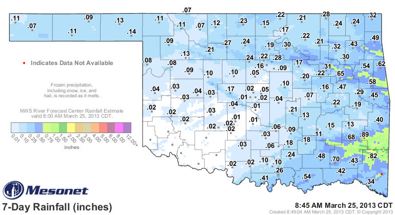
A pitiful showing by Mother Nature last week to be sure, unless you live on those
places under the green regime. Some localized areas in southeastern Oklahoma
received more than ain inch, it appears, but most of the state got the lesser end
of the stick. Don't look now, but we're on another of those streaks we don't like
to see. It has now been close to a month (closer if that month is February) since
parts of the state have seen at least a quarter-inch of liquid precip in a day.
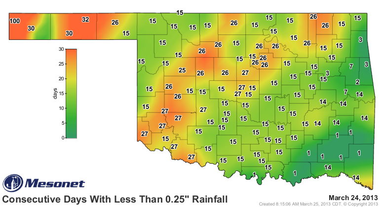
Kenton is having a mighty "guffaw" at that type of whining, since they'll be up
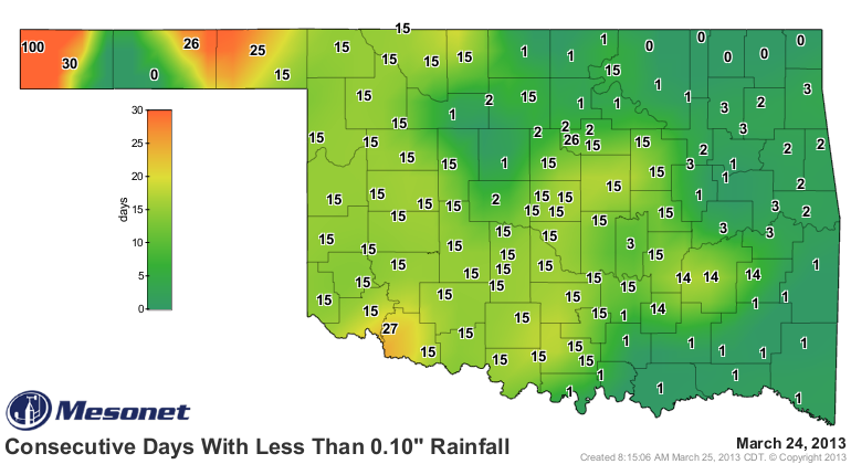
to 101 days after today. The tenth of an inch map looks a bit better for some
areas, but again, Kenton will be at 101 consecutive days after today.
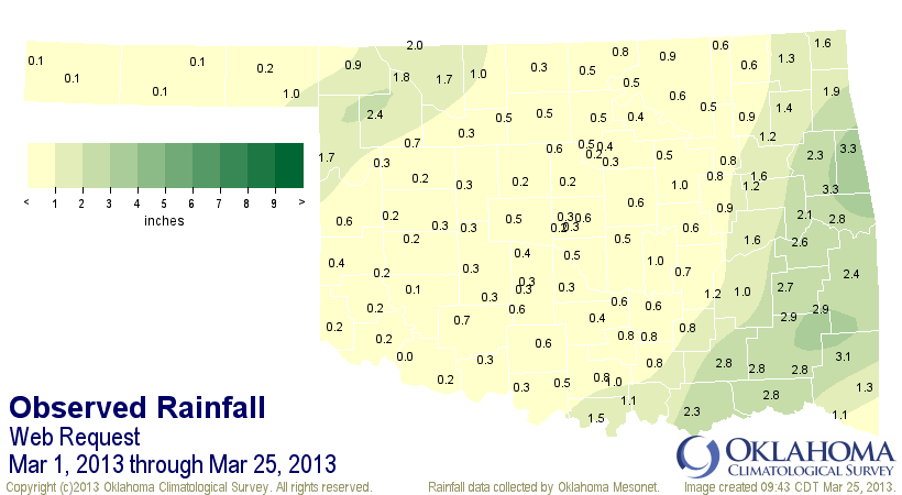
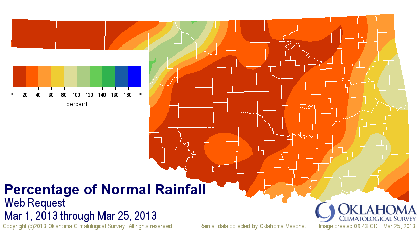
So after our wonderfully wet February (for most), March has landed with a thud
thus far. At least for folks not living in Ellis, Woodward and Woods counties.
The rain and snow this weekend brought the statewide average for the month to
0.95 inches, 1.53 inches below normal, and now ranked as the 18th driest March
1-25 on record.
That's the story of the drought over the last 2.5 years ... one step forward
and two steps back. One saving grace has been the below normal temperatures.
That has both kept the vegetation at bay, easing the stress on the replenished
soil moisture we received over the previous two months, but also kept the
evaporation down. That also helps to keep that soil moisture in place while the
rains have been absent, and also slows the evaporation from some of the state's
beleaguered reservoirs.
With a March 1-24 statewide average temperature from the Mesonet estimated at
46.6 degrees, that drops the month to 2.3 degrees below normal. Average highs
have been 58.8 degrees (normal of 61.5) and average lows have been 34.4 degrees
(normal of 36.2).
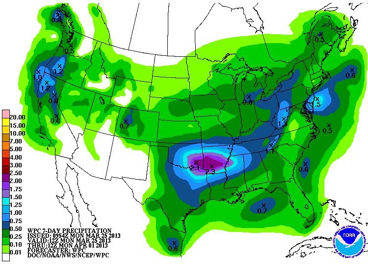
Attention now turns to later this week for our next storm system, with hopes it
won't crash and burn like the last. This one will come with some heat and a
chance of storms, so with a bit more convective precipitation, maybe we can
push those amounts up a bit. The latest 7-day rain forecast from the WPC
(formerly known as HPC) is pinging us with a half-inch to over 2 inches across
the state from the late-week storm.
That type of rain would go a long way in saving our dud of a March thus far. The
first problem is getting it to pan out, of course. Maybe this is the start of
many more forward steps with fewer backwards steps?
Hey, it's a drought! This is how they work.
Gary McManus
Associate State Climatologist
Oklahoma Climatological Survey
(405) 325-2253
gmcmanus@mesonet.org
March 25 in Mesonet History
| Record | Value | Station | Year |
|---|---|---|---|
| Maximum Temperature | 93°F | WOOD | 1998 |
| Minimum Temperature | 15°F | BOIS | 2013 |
| Maximum Rainfall | 2.92 inches | VALL | 2024 |
Mesonet records begin in 1994.
Search by Date
If you're a bit off, don't worry, because just like horseshoes, “almost” counts on the Ticker website!