Ticker for March 21, 2013
MESONET TICKER ... MESONET TICKER ... MESONET TICKER ... MESONET TICKER ...
March 21, 2013 March 21, 2013 March 21, 2013 March 21, 2013
Finally, a GOOD drought forecast
We've been faced with a "drought to persist or intensify" forecast from the CPC
each few weeks since last summer, or at least it seems that way. The latest
forecast brings us much better news, at least in the long run. A bit of
housekeeping first, but remember ... the Ticker doesn't do windows (except
Windows7).
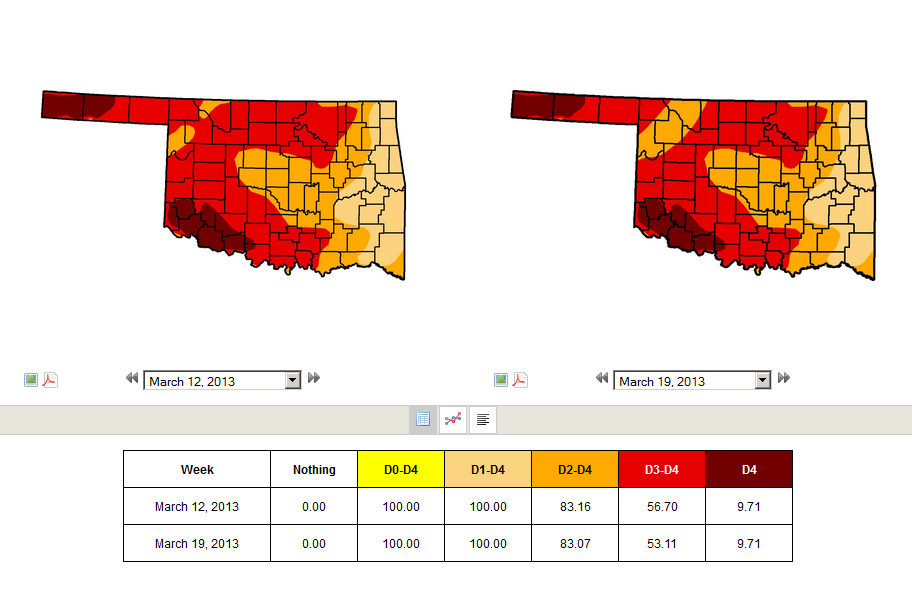
The latest U.S. Drought Monitor report report is basically the same as last
week's, save for a bit more relief showing up in northwestern Oklahoma. Portions
of Woodward County and the surrounding area went from Extreme (D3) drought to
Severe (D2) drought on word of an improved soil moisture profile.
Now, onto more good news. With the spring rainy season just around the corner,
the latest U.S. Seasonal Drought Outlook for the current period through the end
of June has good news for the northeastern half of Oklahoma. Far northeastern
Oklahoma is entrenched in the "drought likely to improve" area, while to the
southeast, they get the "drought ongoing, some improvement" monicker.
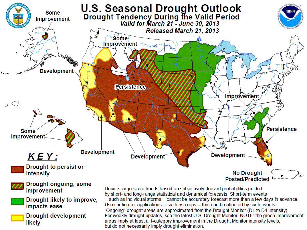
Note that this outlook depicts what the CPC forecaster believes the Drought
Monitor will look like at the end of June. The bad news, of course, is that
they see the drought persisting or intensifying across the Panhandle,
southwestern and west central Oklahoma. Their reasoning is pretty simple ...
combine the rain at the end of this week and no clear dry signal for the
April-June period and you should see some drought impacts ease just a bit.
Here is the reasoning in the forecaster's words hisownself:
"Persistence is forecast across the southern high Plains where the
monthly and seasonal precipitation outlooks tilt the odds towards
below median precipitation. In addition, enhanced odds for above
normal temperatures are forecast from April through June for this
region. Prospects for improvement increase across northeast Oklahoma
due to expected rainfall during the upcoming week and equal chances
for above, near, or below median precipitation forecast in the CPC
monthly/seasonal precipitation outlooks."
The forecast confidence is rated as "medium" for the Southern Plains, so a bit
of a hedged bet there. Here are those April and April-June outlooks spoken of
above.
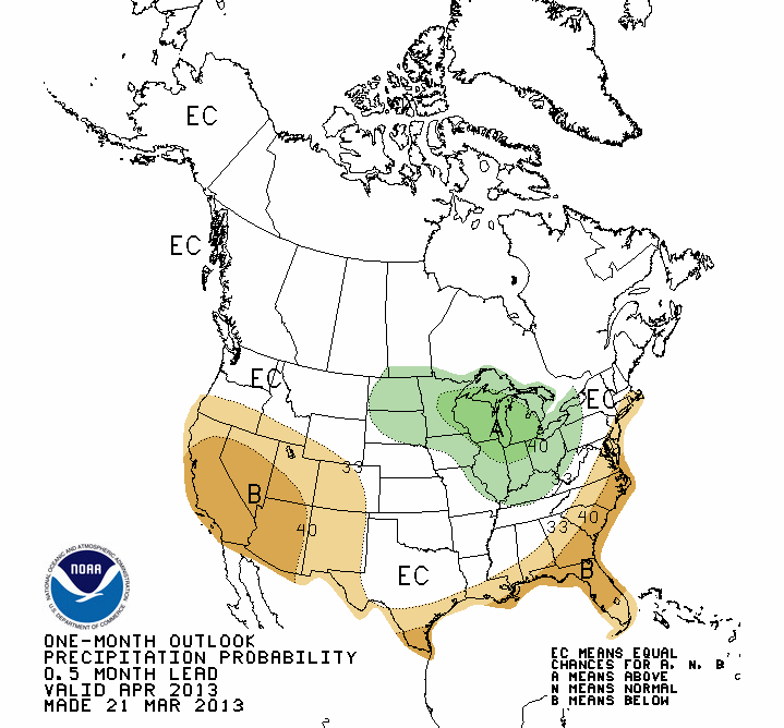
April
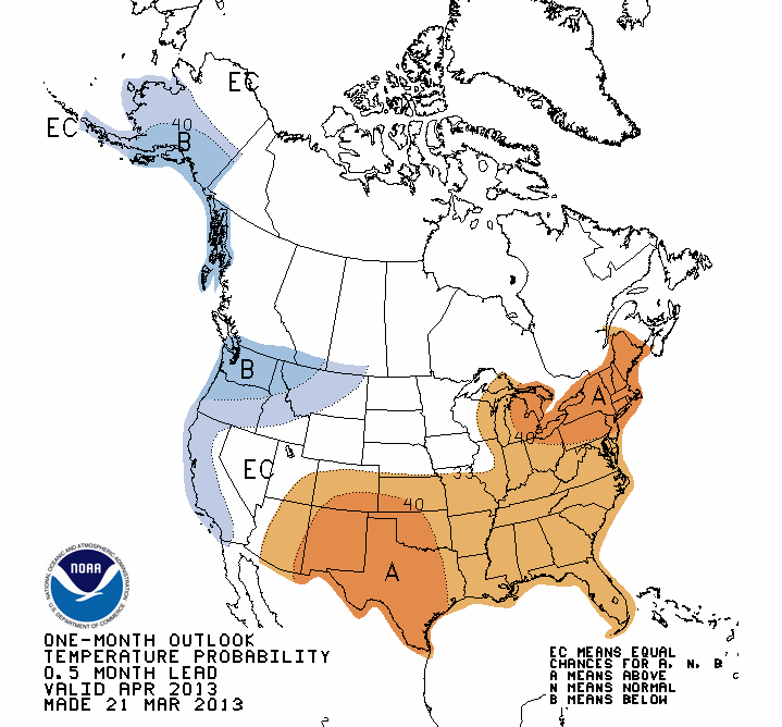
April-June
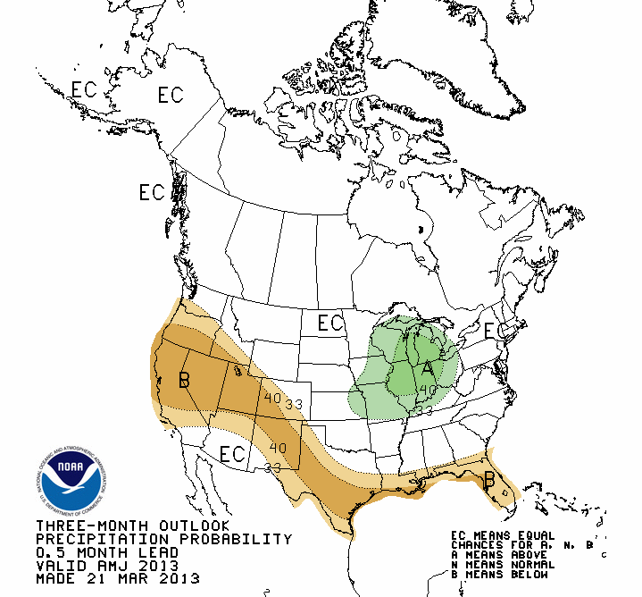
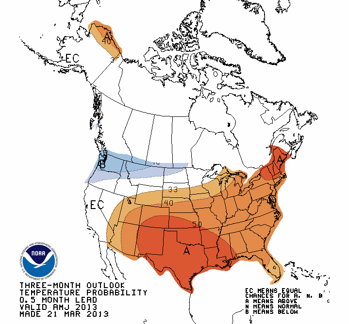
NOTE: THESE MAPS DO NOT SHOW PRECIP OR TEMPERATURE ANOMALY AMOUNTS, ONLY
PROBABILITIES OF ABOVE, BELOW, OR NORMAL VALUES (or the dreaded EC).
First, both the April and April-June precipitation outlooks show the dreaded
"EC" designation for "Equal Chances." Certainly better than the below normal
designation, but in the absence of any strong climate drivers, such as El Nino
or La Nina, the forecaster indicates there are EQUAL CHANCES of above-, below-
or near-normal precipitation amounts through both periods. Another caution,
THIS IS NOT A PREDICTION OF NORMAL ... ALL THREE CATEGORIES HAVE "EQUAL CHANCES"
OF OCCURRING ACCORDING TO THE FORECASTER.
I HAVE NO IDEA WHY I'M SCREAMING ... KNOCK IT OFF!
That's better. For temperatures, the March chill is expected to vanish during
April with warmer weather as we enter the warm season. Farther out into May and
June, the warm weather forecast is based mostly on soil moisture deficits.
Soil moisture deficits and the warm season usually combine to provide warmer
than normal temperatures, since the sun's energy would be used to heat the
ground rather than evaporate soil moisture. The worrisome aspect of the
temperature forecast is that it would also enhance drought conditions, so we're
walking a fine line here if all forecasts verify.
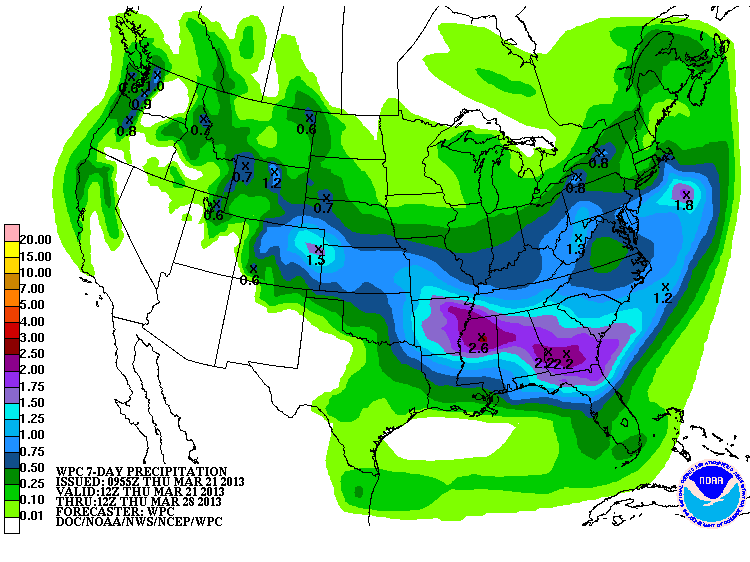
As for our storm system over the next several days, it does appear to have
fizzled just a bit for most of the state. But, as usual, it's better than
nothing since March has turned dry. Here's the 7-day forecast of amounts. We're
still looking at up to an inch across eastern Oklahoma.
Looks like the forecast snowstorm has also fizzled. What? I never mentioned
snow (furiously deleting a past Ticker)!
Gary McManus
Associate State Climatologist
Oklahoma Climatological Survey
(405) 325-2253
gmcmanus@mesonet.org
March 21 in Mesonet History
| Record | Value | Station | Year |
|---|---|---|---|
| Maximum Temperature | 97°F | ALTU | 1997 |
| Minimum Temperature | 10°F | KENT | 2006 |
| Maximum Rainfall | 2.92 inches | LANE | 2022 |
Mesonet records begin in 1994.
Search by Date
If you're a bit off, don't worry, because just like horseshoes, “almost” counts on the Ticker website!