Ticker for February 27, 2013
SPECIAL TICKER UPDATE: State Record Edition
Friends, it is with a somber heart that I report of the possible defeat of one
of Buffalo's snow records. For the month of February 2013, the Ellis County
town of Arnett has a *PRELIMINARY* snowfall total of 42.5 inches. That would
break the previous single-month snowfall amount for a single location in
Oklahoma of 39.5 inches from Buffalo in February, 1971.
The daily tally of Precipitation (liquid equivalent) and snowfall stacks up
thusly (zero values omitted):
-****-
Date Precipitation Snowfall
2/12/2013 0.02 2.5
2/13/2013 0.4 4.0
2/20/2013 0.3 2.0
2/21/2013 0.4 8.0
2/22/2013 0.4 4.0
2/25/2013 0.5 4.0
2/26/2013 3.3 18.0
----------------------------------
Totals 5.32 42.5
-***-
As stated previously, this is still preliminary and will have to go through the
quality control procedures of the NWS and NCDC. I suggest everybody rush out to
their favorite place of worship and pray that this is all a big mistake!
In all seriousness, quite a feat for that record to fall if it verifies,
especially the 5.32 inches of liquid equivalent associated with the snow. And
there could be another station still lurking out there with a higher total.
Nothing will be official until the data are verified.
Gary McManus
Associate State Climatologist
Oklahoma Climatological Survey
(405) 325-2253
gmcmanus@mesonet.org
MESONET TICKER ... MESONET TICKER ... MESONET TICKER ... MESONET TICKER ...
February 27, 2013 February 27, 2013 February 27, 2013 February 27, 2013
Meltage
Temperatures rose above freezing yesterday across northwestern Oklahoma.
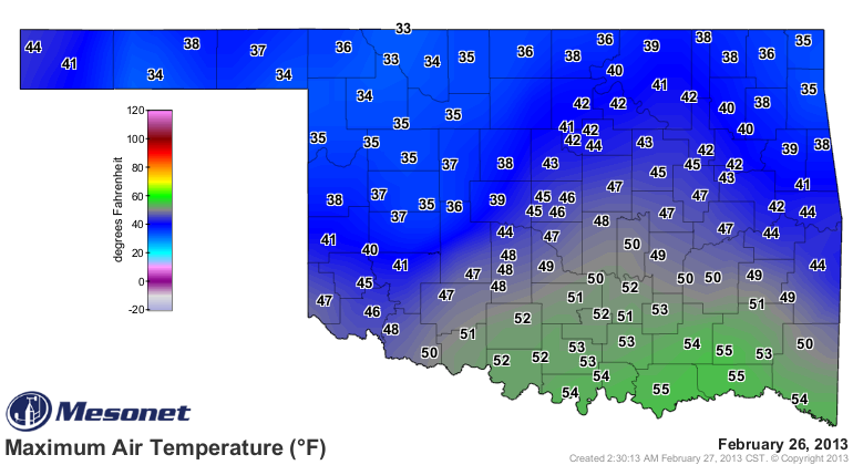
And forecast to go above freezing today.
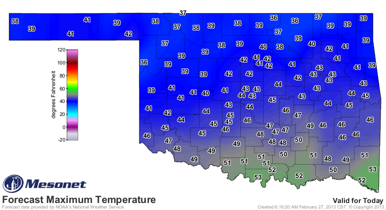
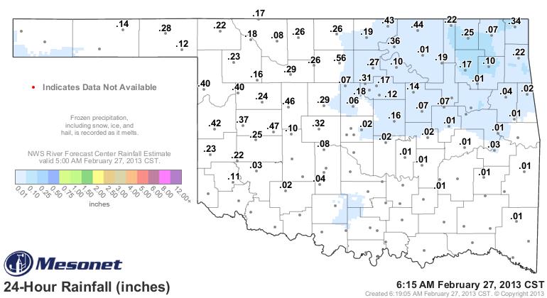
That, along with the nearly-March power of the sun, has sped up the melting of
the snowpack up in the northwest, making it seem as though that area continues
to get rainfall on the Mesonet rain total maps. That's why you see up to a half
an inch of rain across some parts of the state, but no radar estimate overlay.
The "rain" occurred over two days ago.
It's the gift that keeps on giving! Of course, it was something of a lump of coal
in the stocking, leaving tens of thousands without power and an entire section
of the state paralyzed. The statewide average for February is up to 2.99 inches,
which would rank as the 12th wettest on record. Moving up the ranks!
Some amazing snow totals from up that way, however, thanks to the consecutive
snowstorms. Alva, for instance, came within inches of breaking the monthly
snowfall total for the state. The NWS COOP observer located one mile west of
Alva recorded 35.6 inches of snow for the month thus far. That's about 4 inches
away from the all-time record of 39.5 inches from the best place in the
universe, Buffalo, set back in February 1971.
All records owned by Buffalo will remain forever, even if I have to grab a
hair drier and a 100-mile long extension cord. Seriously though, that was a
close one.
More importantly, that snow, along with a bit of rain, amounted to 4.95 inches
of liquid moisture for the Alva area. THAT is a drought-denter right there,
and the bulk of it will be able to moisten those soils as it slowly melts.
Combine that with the 0.82 inches from January and they have a grand total of
5.77 inches for the January-February period.
We will patiently await the next storm system for further help. The CPC insists
it's coming sometime about 8-14 days from now.
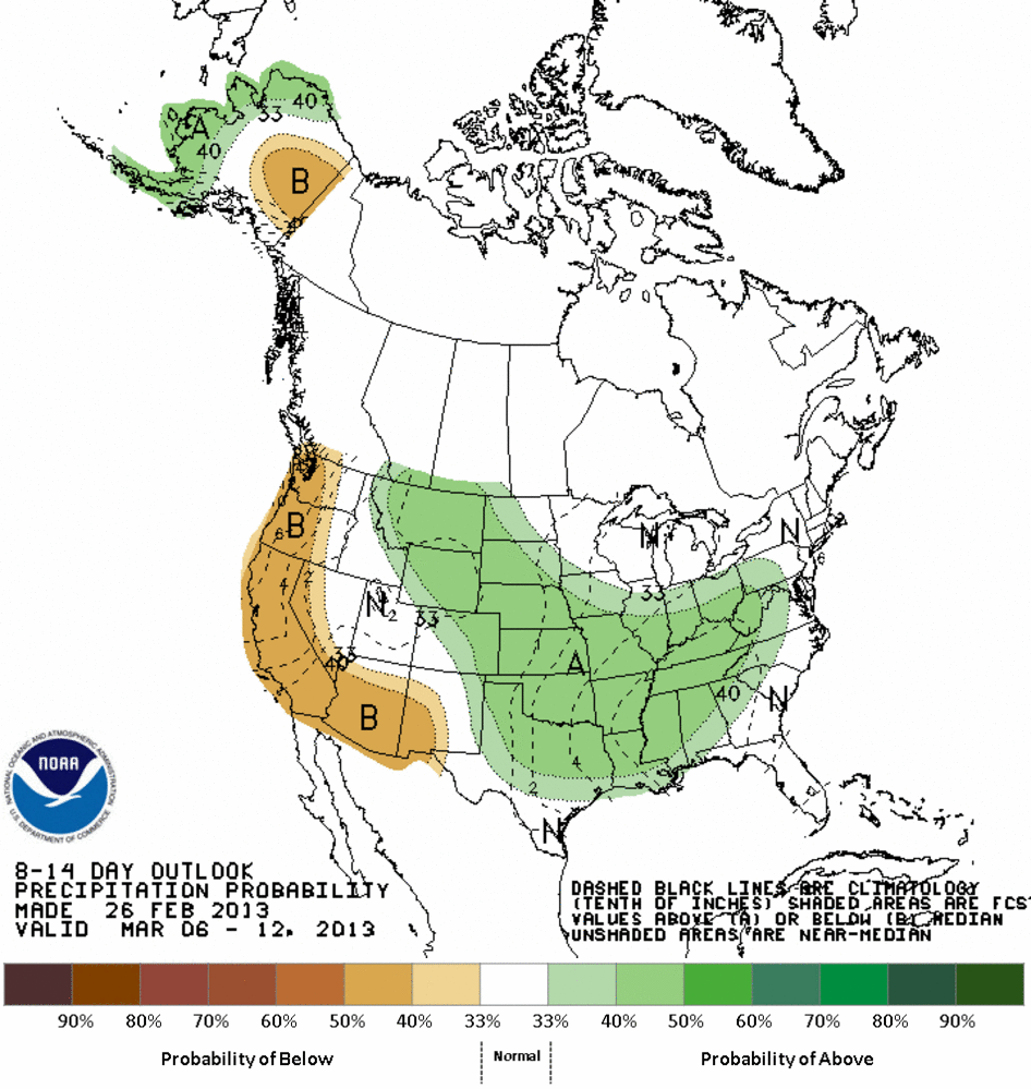
Maybe just a hint of that showing up on the 7-day HPC rain forecast.
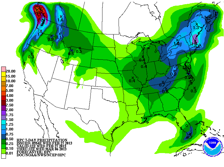
That's okay. We're patient. We can wait.
Alright, where's the rain???
Gary McManus
Associate State Climatologist
Oklahoma Climatological Survey
(405) 325-2253
gmcmanus@mesonet.org
February 27 in Mesonet History
| Record | Value | Station | Year |
|---|---|---|---|
| Maximum Temperature | 90°F | WALT | 2011 |
| Minimum Temperature | 4°F | BEAV | 2002 |
| Maximum Rainfall | 1.82″ | CLOU | 2018 |
Mesonet records begin in 1994.
Search by Date
If you're a bit off, don't worry, because just like horseshoes, “almost” counts on the Ticker website!