Ticker for February 25, 2013
MESONET TICKER ... MESONET TICKER ... MESONET TICKER ... MESONET TICKER ...
February 25, 2013  February 25, 2013  February 25, 2013  February 25, 2013


Historic (maybe!)

By now you have probably heard a snippet or two about a bit of snow falling out
west, destined to spread east as well. Some have called the storm "historic." I'd
argue that to climatologists, all storms are historic. But, the point is
valid by the more strict definition of the word ... by the time this one is over,
we could see some near-record numbers.

Now there's little a devilishly handsome associate state climatologist can do
during a storm like this. There's nothing I can do either (see what I did
there?). I suppose I could activate the Emergency Milk and Bread Broadcasting
System, but that's generally for the week before. Plus, it changes its name each
time so nobody knows what it is. No, this is a time for those scruffy-looking,
heroic operational types from across the hall at the NWS to step in and keep
folks informed.

Hey, I didn't create these visual stereotypes ... Hollywood did! And they're
usually pretty accurate, right?

Typical meteorologist - Dusty from "Twister"

Typical climatologist - Jack from "The Day After Tomorrow"


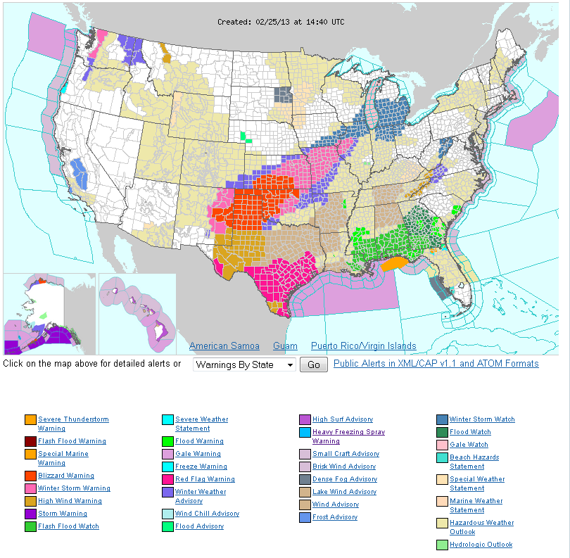
But, you can see from the NWS warning map the trouble we're seeing today.


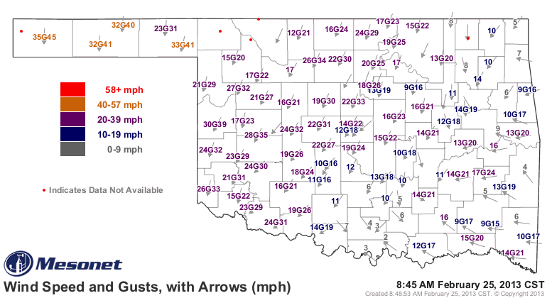
Yep, we're smack-dab in the middle of blizzard city! Heavy snows have closed
all roads in the Panhandle, with winds of 30-35 mph, gusting to 45. Check it
out on the Mesonet.


For the drought, this is very important reinforcing moisture. I know it comes
with some pretty bad side-effects this time, but when in Oklahoma does it not?
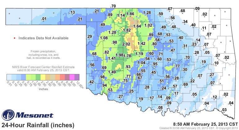
Here's the latest total map with RFC radar-estimated overlay from the Mesonet.
The radar estimates are important once again since the Mesonet won't register
frozen moisture until it starts to melt. Moisture amounts of 1-2 inches already
out in western Oklahoma, with more to come!


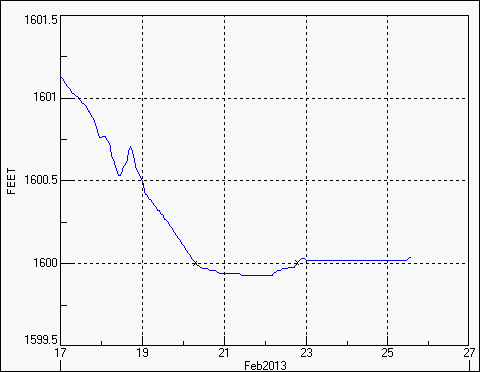
Hopefully this will perk Canton Lake up, which bottomed out at 11% of capacity
after the water release to OKC. You can just now see it start to nose up just
a bit.


Now, back to where I come in ... the record-keeping part. Just in case (not
predicting anything!) we get close to any records, here are the official
numbers.

24-hour snowfall: Spavinaw, 27 inches (Feb. 8-9, 2011)
Storm-total snowfall: Buffalo, 36 inches (Feb. 20-22, 1971)
Monthly snowfall: Buffalo, 39.5 inches (February 1971)
Seasonal snowfall: Beaver, 87.3 inches (1911-12)

This isn't unprecedented in recent memory, whether you're talking blizzard or
heavy snow. There's the aforementioned Spavinaw record from just a couple of
years ago, and that amount broke the record set during a blizzard in late March
2009. Freedom and Alva recorded 26 inches in an early spring blizzard that
year.

All that's left to do now is to hunker down and stay safe. Get where you need
to be and stay off the roads. Check out the NWS office pages often, and turn
those TVs on to the local channels for weather updates.

Who's scruffy looking?

Gary McManus
Associate State Climatologist
Oklahoma Climatological Survey
(405) 325-2253
gmcmanus@mesonet.org
February 25 in Mesonet History
| Record | Value | Station | Year |
|---|---|---|---|
| Maximum Temperature | 85°F | HOLL | 1999 |
| Minimum Temperature | -2°F | CHER | 2003 |
| Maximum Rainfall | 1.79″ | KIN2 | 2013 |
Mesonet records begin in 1994.
Search by Date
If you're a bit off, don't worry, because just like horseshoes, “almost” counts on the Ticker website!