Ticker for February 14, 2013
MESONET TICKER ... MESONET TICKER ... MESONET TICKER ... MESONET TICKER ...
February 14, 2013  February 14, 2013  February 14, 2013  February 14, 2013


On the road again

Seems like I used to have an office I worked out of ... at least a time or two. But the drought rolls
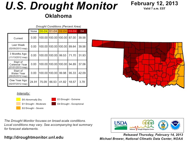
on, as does my drought tour. We did see some improvement in the U.S. Drought Monitor that I
wanted to tell you about. As you can see, a bit more improvement in the eastern sections of the state,
from D3 to D2.


That improvement was based on the rain we saw last weekend. The rain and snow we just had
a few days ago won't be realized on the DM map until next week, and then after we take a glance
at any improvements in the impacts.

We do have a chance for more precip on the next week. Nothing major, but at least something.
After that, there are indications of another major storm in about a week. It's just now starting
to show up on the latest 7-day rainfall map.


As usual, we really need that to spread to the west. I know of a certain little sad farm pond south
of Buffalo that needs a nice, long drink.

Gary McManus
Associate State Climatologist
Oklahoma Climatological Survey
(405) 325-2253
gmcmanus@mesonet.org
February 14 in Mesonet History
| Record | Value | Station | Year |
|---|---|---|---|
| Maximum Temperature | 84°F | FREE | 2018 |
| Minimum Temperature | -18°F | KENT | 2021 |
| Maximum Rainfall | 3.30″ | MTHE | 2017 |
Mesonet records begin in 1994.
Search by Date
If you're a bit off, don't worry, because just like horseshoes, “almost” counts on the Ticker website!