Ticker for January 22, 2013
MESONET TICKER ... MESONET TICKER ... MESONET TICKER ... MESONET TICKER ...
January 22, 2013 January 22, 2013 January 22, 2013 January 22, 2013
And on the Seventh Day
I wake up early every morning and blearily stumble into a recliner (hopefully mine
and not my neighbors ... I'm sure the cold weather would wake me) and click the TV
on. I scan the local channels to get all the forecasts by our fantastic and very
capable local weather folks, looking for a sign of rain on that seventh day. The
problem is we never really get significant surprises within that seven-day
forecast...the science has just advanced too far, darn it! So it's always the
seventh day I look at, hoping to see the symbol for rain on there.
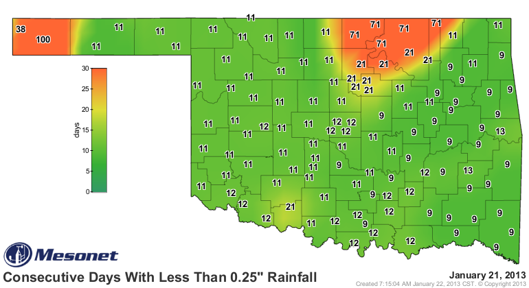
Still nothing big yet. Drought rolls on, the Mesonet "days without rainfall
maps" continue to add digits, and we look to next week for the hope of rain.
Does that sound familiar? Well, there is a storm system showing up in the models
for next week (where have we heard that before, right?) that could bring us
some nice moisture. The problem is, if it actually happens, it will be ANOTHER
starting point for drought relief. These maps will be up around 20 days for
both at least a tenth and a quarter of an inch (for the western Panhandle and
north central Oklahoma...even longer!).

As a usual caution, when looking that far out (next Tuesday-Wednesday time
frame), remember that the storm system in question is still far off the coast
over the Pacific Ocean and things could change rapidly when it starts getting
sampled by our observation networks. But hey, what do we have to lose, right?
The good news is that we are in the cool season, so the rain we had two weeks ago
isn't being used as quickly. However, the days grow warmer each day, at least
climatologically speaking, as we approach February on into March (quick graph
thrown together below).
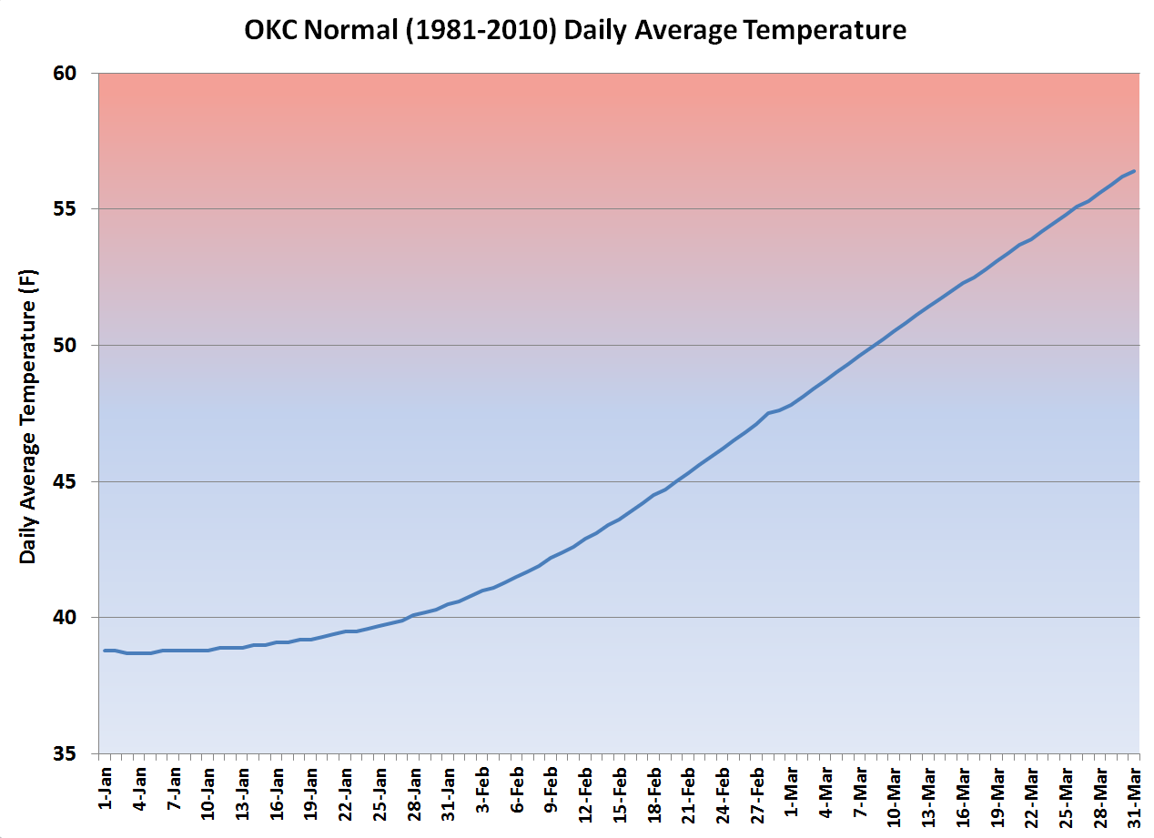
So as the temperatures go up, plants start growing and evaporation increases,
and therefore so does the water stress. When we started out with such a warm
January-March last year, that was nice and all, but it also spelled trouble
when the rains went away later in the spring.
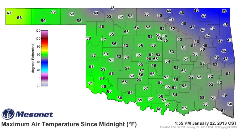
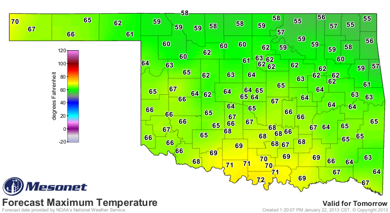
Speaking of spring, get thee to Kenton as quickly as possible! Their
temperatures have soared into the upper 60s, a preview of what the rest of the
state could see over the next couple of days before our next front moves in
on Thursday.
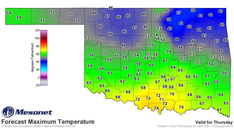
And remember my old adage on any given day: if you're not in Kenton (and I
would assume 3,791,491 of our state's 3,791,508 residents are not), you've
already lost!
Gary McManus
Associate State Climatologist
Oklahoma Climatological Survey
(405) 325-2253
gmcmanus@mesonet.org
January 22 in Mesonet History
| Record | Value | Station | Year |
|---|---|---|---|
| Maximum Temperature | 84°F | WAUR | 2009 |
| Minimum Temperature | 1°F | HOOK | 2007 |
| Maximum Rainfall | 2.28 inches | BROK | 2024 |
Mesonet records begin in 1994.
Search by Date
If you're a bit off, don't worry, because just like horseshoes, “almost” counts on the Ticker website!