Ticker for January 23, 2013
MESONET TICKER ... MESONET TICKER ... MESONET TICKER ... MESONET TICKER ...
January 23, 2013 January 23, 2013 January 23, 2013 January 23, 2013
Bleary-eyed Potpourri
Yeah, we stayed up late and then got up early to check the latest forecasts on
TV and from the NWS. And no, that doesn't make us weird. Just really really
tired. The weirdness is there all the time.
There are several rain chances showing up on the extended forecast, as well as
a couple of bouts with frigid air. In between, we will see March-like weather,
however. Not quite the beginning of 2012's opening stanza on the way to the
warmest year on record, but not too shabby. We will see lots of 60s and even a
few 70s over the next week. The rain amounts are still a bit fuzzy, but anything
above zero is certainly welcome. The medium-range outlooks finally turned green
for Oklahoma, with increased odds of above normal precip.
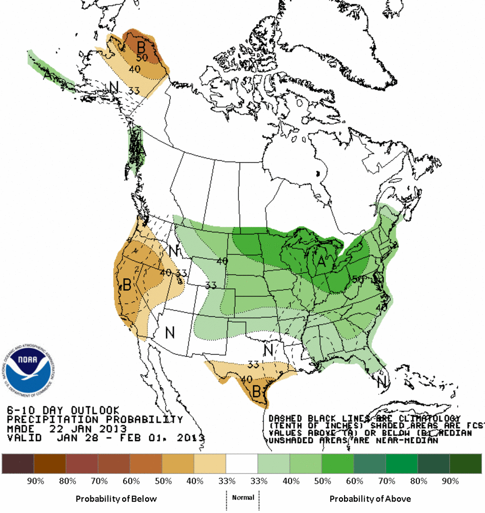
Above normal for this time of year is about a dollop, but again, we'll hope for
a few toad stranglers. Wonder what the latest 7-day forecast total says?
WAIT! HOLD ME UP, I'M FEELING FAINT FROM SHOCK! The latest 7-day rainfall forecast
from HPC has the highest rainfall amounts in SE OK through next Wednesday morning
and very little out west. Let's hope the wealth of moisture is spread to the
west by the time the rain actually falls.

---------------------------------------------------------------------------------
A decidedly non-green wheat crop
Dr. JD Carlson of OK-FIRE fame points out an interesting, uh ... point, to us.
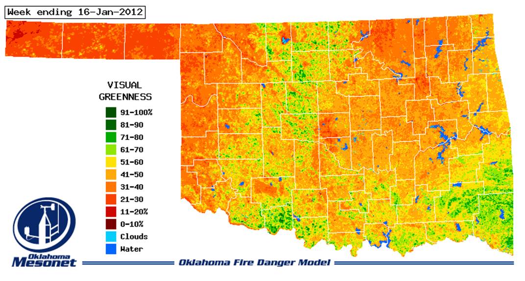
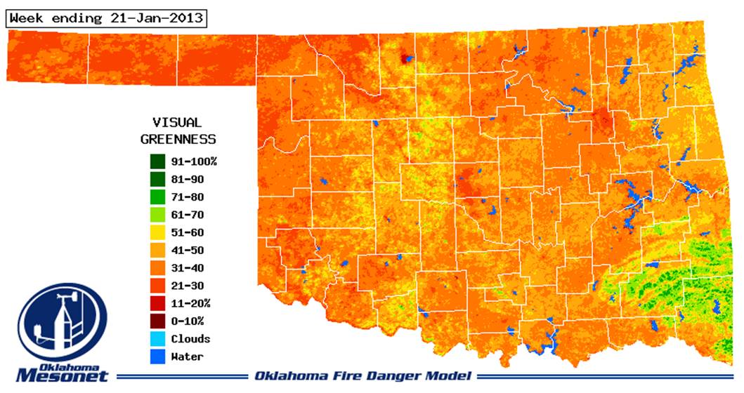
Looking at the satellite maps of visual greenness used to formulate fire danger
across the state, the state's wheat crop is sort of a no-show compared to last
year at this time. Check out this image from the week ending January 16, 2012.
You can see the Oklahoma wheat crop, urged on by a very wet and warm winter
period, has emerged quite nicely from southwestern up through north central
Oklahoma.
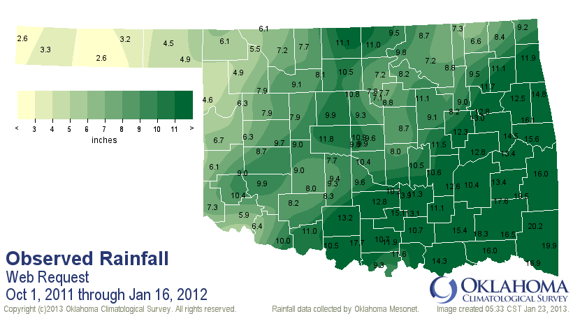
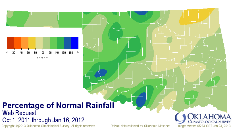
Oct 1, 2011-Jan 16, 2012, rainfall maps
Now take a look at that same satellite view from this year. Very little green
to speak of, a sure sign that this year's wheat crop has been hampered by the
ill-timed scarcity of moisture since the fall planting season.
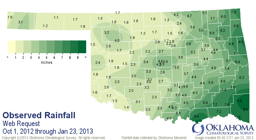
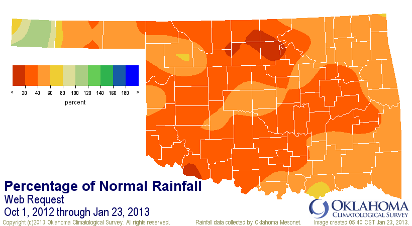
Oct 1, 2012-Jan 23, 2013, rainfall maps
For another view, here is a look at the departure of average greenness maps
for the January 15-21 period. Now this map is compared to the average greenness
seen during this same period for the last couple of decades. You can clearly
see (for those of you avoiding Grandpa's cough medicine) the "browner" than
average nature of Oklahoma's wheat country, which would normally be green at
this time of year.
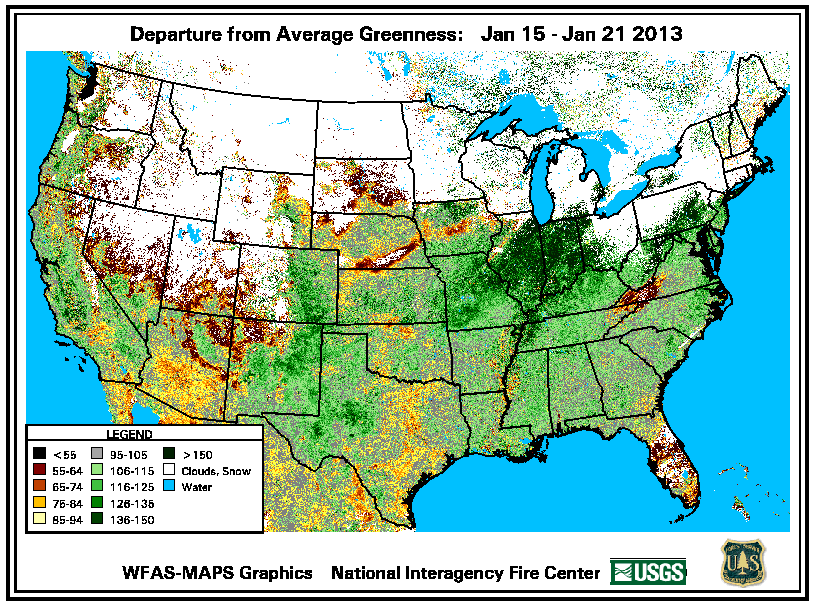
It's actually greener than average for this time of the year over parts of the
state. I don't know how to attribute that, or that densely green area up to
the northeast. If I had to guess (remember, I'm in weather ... we call that
"science"), I'd say it's due to the abnormally warm weather seen across the
country this fall and winter. I know that I had green bermudagrass in my yard
all the way up until the big freeze on Christmas eve. At any rate, north
central Oklahoma's wheat looks particularly bad for this time of year.
It's not surprising that the far western Panhandle is the one area of the state
to have above normal precip since Oct. 1 this growing season, and also be the
primary area of the state much greener than normal.
-------------------------------------------------------------------------------
Better there than here!
Finally, keeping with the view from space, take a look at this stunning pic
of the frozen Great Lakes region from NASA. You can see clouds forming over
the relatively warmer lake surfaces and then streaming over land, as well as a
bit of ice forming on southwestern Lake Michigan (that big one in the center).
The farther north you go, the more frozen the land looks (and is).

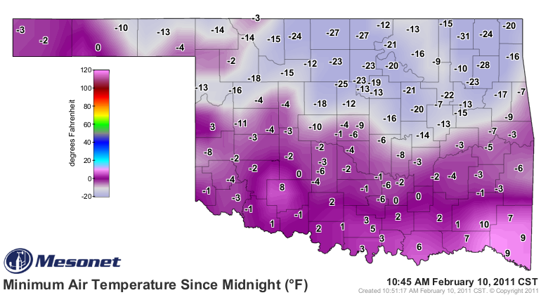
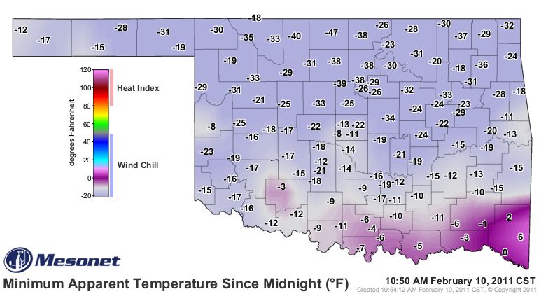
This is the coldest air to hit much of that area in two years. Oddly enough,
since February 10, 2011. Okies worth their frozen salt will remember that's the
last time it was REALLY cold in Oklahoma, when the Nowata Mesonet site hit
31 degrees below zero, setting the state's all-time lowest minimum temperature
record. Seven days later, it was in the 70s and the weather has never really
looked back, with drought and warmth.
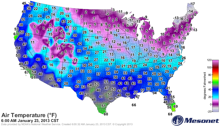
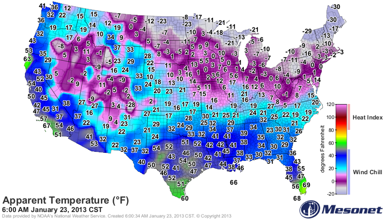
If that picture ain't enough to convince you, take a look at the 6am U.S.
temperature and wind chill maps. Like I said, better there than here!
Look familiar? The low temperature and wind chill maps rom February 11, 2011:
Gary McManus
Associate State Climatologist
Oklahoma Climatological Survey
(405) 325-2253
gmcmanus@mesonet.org
January 23 in Mesonet History
| Record | Value | Station | Year |
|---|---|---|---|
| Maximum Temperature | 78°F | WEBB | 2002 |
| Minimum Temperature | -3°F | HOOK | 2014 |
| Maximum Rainfall | 1.90″ | STIG | 2002 |
Mesonet records begin in 1994.
Search by Date
If you're a bit off, don't worry, because just like horseshoes, “almost” counts on the Ticker website!