Ticker for January 17, 2013
MESONET TICKER ... MESONET TICKER ... MESONET TICKER ... MESONET TICKER ...
January 17, 2013 January 17, 2013 January 17, 2013 January 17, 2013
Sherman T. Drought
If this drought was "M*A*S*H" it would be in Lt. Col. Henry Blake's final season.
If it was "The Karate Kid" movie franchise, we'd be watching a seemingly 43-year
old Ralph Macchio still learning karate from Mr. Miyagi in a rather far-fetched
plot about revenge (the first two had very believable story lines *wink-wink*).
I would try a corollary with the "Die Hard" series, but I have tried to wipe "Die
Hard With A Vengeance" from my mind. Here's another ... we're all tired of this
drought as it continues on in its third year, and it looks like it will be with
us for a bit longer.
The new U.S. Drought Monitor map was an exercise in give-and-take this week. As
promised, we did see some improvement in far southeastern Oklahoma, thanks to
4-7 inches of rain since the beginning of December. Idabel led the way with
7.3 inches in the gauge, and Broken Bow had 7.1 inches. The rest of the state
had from about a half-inch to 2 inches. North central Oklahoma remained puny as
seen on the percent of normal map, getting about 20-30% of normal for that
time frame.


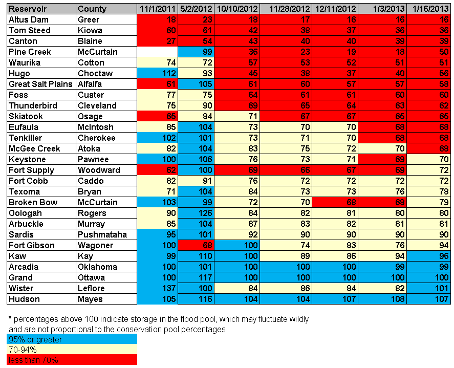
Looking at the impacts, we did see the reservoir levels come up by varying
degrees down that way. Lake Hugo went from 40% of capacity to 56%, and Pine Creek
was up to 50% from 18%. Broken Bow got out of the red from 68% to 79%. Most
levels either stayed the same or increased slightly.
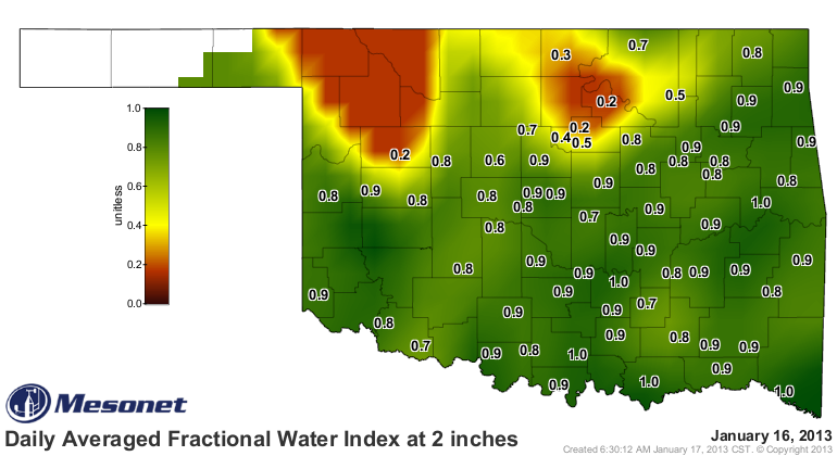
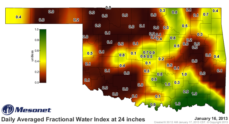
The topsoils across the state contain some good moisture, but the lower levels
remain bone dry across much of the state.
We weigh those varying precipitation amounts versus the improvement (or non-
improvement) of the impacts, and the longer-term moisture shortages and we come
up with the new DM map.
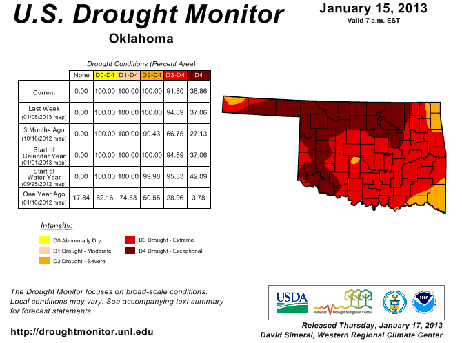
The Extreme (D3) area in the far southeast went to Severe (D2), but the D3
area up around Kay, Osage and Washington counties went to Exceptional (D4). So
we saw a decrease in the amount of D3 from last week (from 58% to 53%), but an
increase in the area of D4 (from 37% to 39%). And as has been the case for
awhile now, the entire state is covered by Severe (D2) to Exceptional (D4)
drought.
As for those longer-term issues, which are reflected in the reservoir levels
and lower soil moisture deficits, we can either go back to October 2010 or
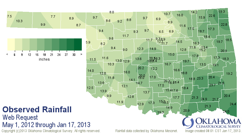
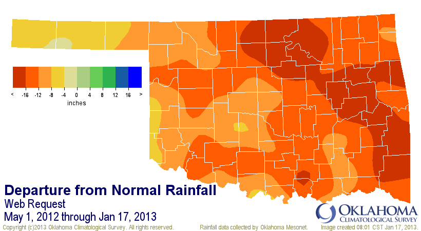
simply May 2012 to look at those. Here are the Mesonet rainfall maps since
May 1, 2012. Through January 17, 2013, we've seen a statewide average of 14.37
inches, 13.34 inches below normal, and the driest such period since 1921.
Remember we're coming off the driest May-December on record at 13.8 inches.
The driest May-January on record is the 14.51 inches from May 1914-January 1915.
We've had about 0.9 inches thus far in January, so at least we will probably
not claim the driest May-January on record, but we'll be darned close. Of course
these are Mesonet numbers for January thus far, so we'll see what NCDC comes up
with.
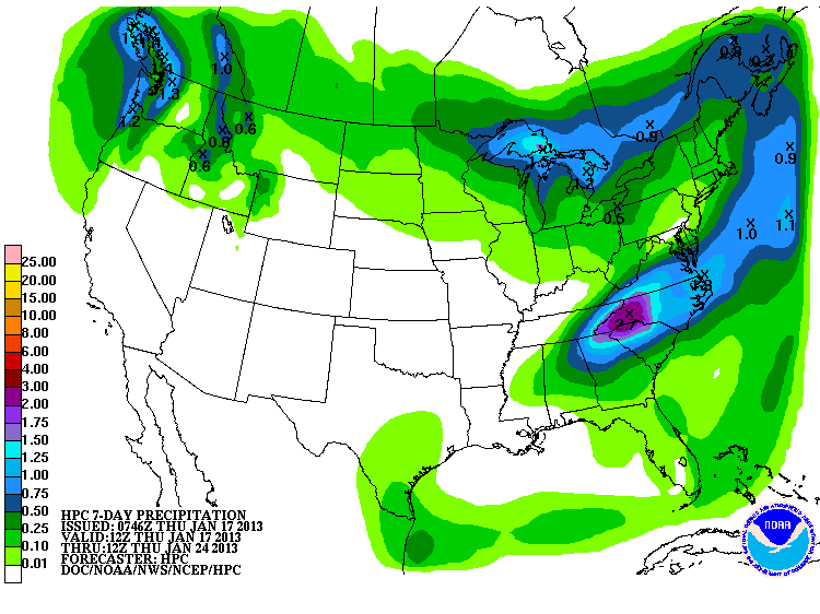
But it does appear we might be done with the bulk of the precipitation for the
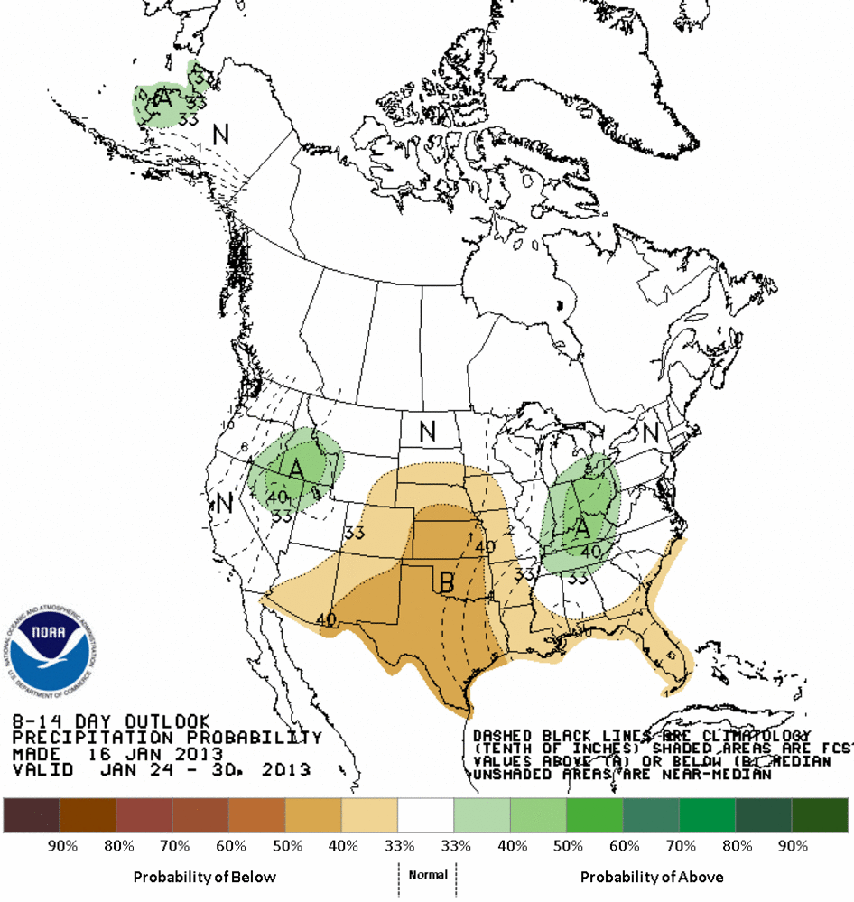
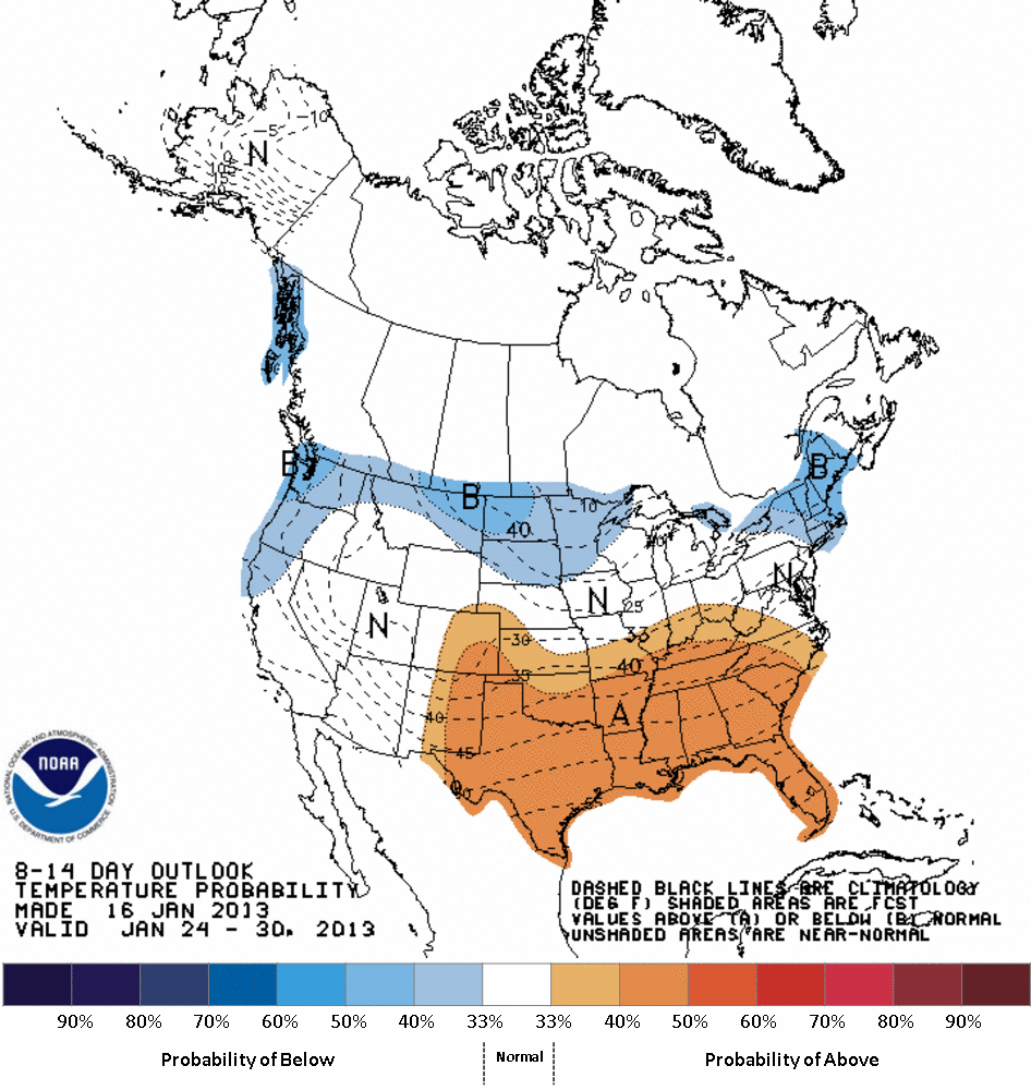
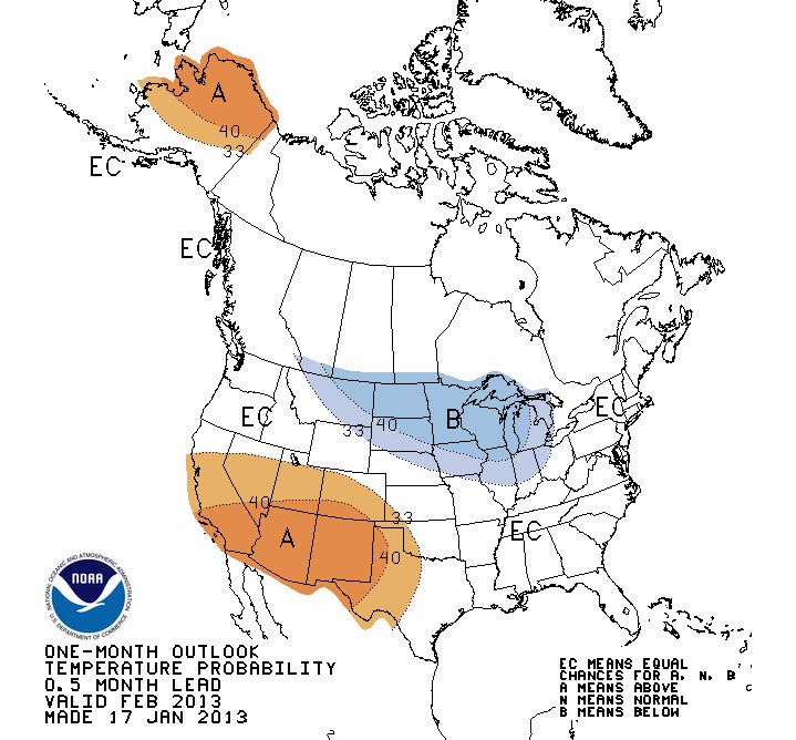
month. Maybe into February as well? The short-, medium- and long-term outlooks
don't bode well for our drought fortunes.
7-day moisture forecast
Medium-term (Jan. 24-30) moisture and temperature outlooks
February outlooks

February-May outlooks


Now all of that culminates in a depressingly brown Seasonal Drought Outlook map.
This map is effective for now through the end of April. Persistence or
intensification is the call for all of Oklahoma, unfortunately.

While I just gave you all the reasons for the bleak outlook on the seasonal map,
I'll give you CPC Forecaster Dave Miskus' words as well:
"Widespread precipitation during the latter half of December and
early January boosted moisture and improved drought conditions
across parts of Texas. Additional precipitation is expected during
the next few days, but mainly confined to eastern sections of Texas.
Unfortunately, a pattern change in the CPC 6-10 and 8-14 day outlooks
tilt the odds in favor of below median precipitation. The CPC February
and FMA outlooks and the CFSv2 and NMME models all indicate enhanced
chances of below median precipitation for the southern Plains, and
the seasonal outlooks indicates favorable odds for above normal
temperatures. Although current wet conditions have warranted
improvements to the drought in Texas, this latest guidance points to
a return of drier conditions. Accordingly, drought should persist or
develop in Texas and the southern Plains."
Now after all of that negativity, let me give you a ray of hope. As we've said
many times on here, Mother Nature is in control of the permanent magic marker.
All the outlooks in the world can't stop her from doing what she will. It looks
dry for the short term, but we are coming into spring with renewed hope. So
take these forecasts and outlooks seriously, but keep your eyes, and your hopes,
up. We've seen abrupt about-faces in the past, so they're in our future as
well.
Let me say this as a word of caution, however. Should these outlooks hold any
water (or lack thereof), the odds of a full third year of drought get a lot
higher. We do not want to make it to Col. Potter (season 4) territory. Or,
Heaven forbid, Charles Emerson Winchester, III.
Now, FOCUS, Mother Nature! We've done the rain off, now do the rain on.
Gary McManus
Associate State Climatologist
Oklahoma Climatological Survey
(405) 325-2253
gmcmanus@mesonet.org
January 17 in Mesonet History
| Record | Value | Station | Year |
|---|---|---|---|
| Maximum Temperature | 76°F | WAUR | 2000 |
| Minimum Temperature | -8°F | MIAM | 2018 |
| Maximum Rainfall | 2.39″ | PRYO | 1996 |
Mesonet records begin in 1994.
Search by Date
If you're a bit off, don't worry, because just like horseshoes, “almost” counts on the Ticker website!