Ticker for December 3, 2012
MESONET TICKER ... MESONET TICKER ... MESONET TICKER ... MESONET TICKER ...
December 3, 2012 December 3, 2012 December 3, 2012 December 3, 2012
I love this time of year ...
The Christmas decorations, people bustling about bundled up in the shorts, t-shirts
and flip-flops, sweat flying from their brows from the heat and also the thought
of their credit card bills. Luckily they can have all the hot chocolate they want ...
and they don't even have to heat the water! No, it has not been looking a lot like
Christmas. Even though there are big changes possible for next week, the main story
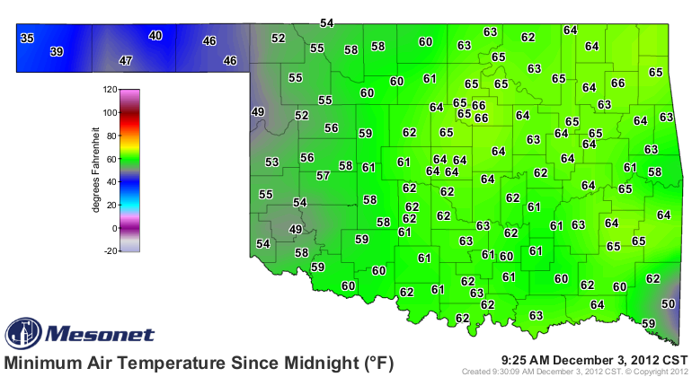
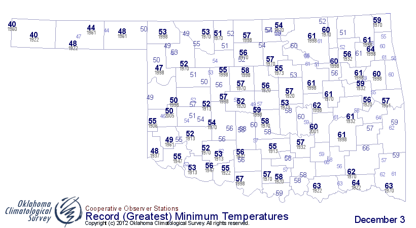
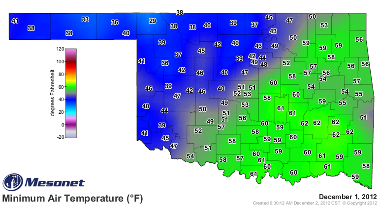
now is the heat. Record highs and warm-lows are cropping up left and right. Lows
this morning were in the 50s and 60s for most of the state. In fact, those lows are
as much as 10 degrees higher than the normal highs for December 3! Now there is a
front coming through during the day so these numbers will probably go down tonight,
but an incredibly warm morning for early December. If they last, they will have
easily broken records for warmest lows for this date.
Yesterday was also warm for southeastern Oklahoma during the morning, then the
entire state in the afternoon. A weak front kept the drier, colder air over the
northwestern two-thirds of the state. But we the upper 60s for lows in the
southeast were only about 10 degrees off the record highs for down there.
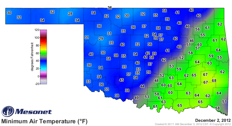
Here's another zinger ... the highest minimum temperature ever recorded on Dec.
3 in Oklahoma history was 64 degrees in Boswell back in 1993. Several of our
Mesonet sites broke that by 3-4 degrees, led by the 68 at Talihina, a new
all-time record for the day for anywhere in the state. And that led to some
record-breaking highs for the afternoon with widespread 70s and 80s.
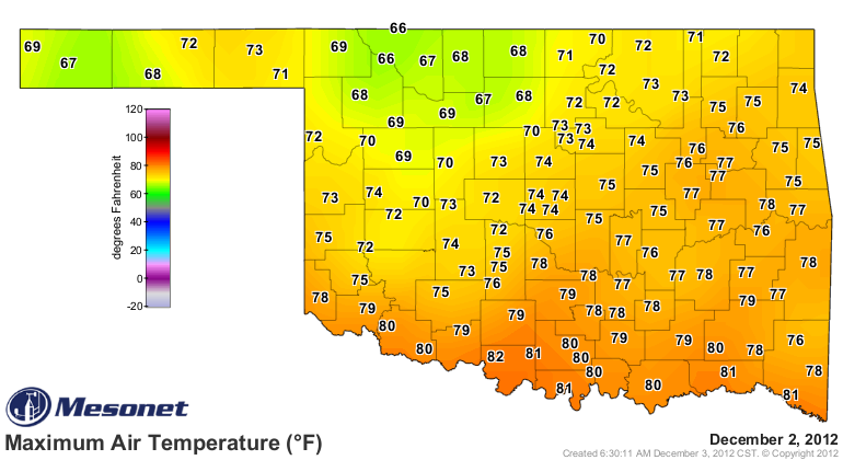
All this after the same type of numbers for Saturday as well.
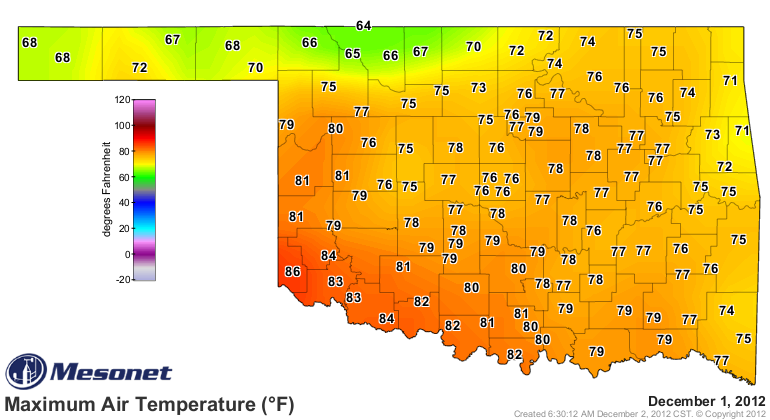
One more zinger! The statewide average temperature (high and lows averaged together)
on Dec. 1 was 63.5 degrees according to the Oklahoma Mesonet. Compare that to other
days on the Mesonet and also from the NWS Cooperative network back in history and
it finishes as the third warmest December day on record. Tops is Dec. 31, 1951, with
an average of 67.5 degrees. Meeker had a high of 85 degrees and a low of 70 degrees
that day. Yikes! What a way to ring in a new year. The number two average was 64
degrees on Dec. 24, 1955.
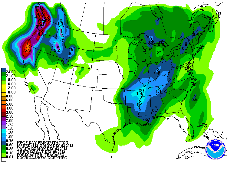
The fronts we see today and late in the work week could have some decent rains
associated with them, but it looks contained mostly for far eastern Oklahoma
right now. Good for them! They need it like everybody else does.
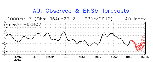
You'll probably be hearing more and more about chances for a return to actual
winter weather next week, with some frozen precip even being hinted at right
now. That fits with the forecast changes we're seeing in the Arctic Oscillation
and North Atlantic Oscillation, with both scheduled to dip far into negative
territory (meaning dips in the jet stream and an opening for arctic air to
plunge to the south).

All of that bidness is still a long way out, but sometimes it's good to get
another topic besides drought. Oh yeah, I'm still killing flies in my house.
Either I need to clean or a good 15-degree day from Mother Nature.
Gary McManus
Associate State Climatologist
Oklahoma Climatological Survey
(405) 325-2253
gmcmanus@mesonet.org
December 3 in Mesonet History
| Record | Value | Station | Year |
|---|---|---|---|
| Maximum Temperature | 84°F | DURA | 2005 |
| Minimum Temperature | 0°F | NOWA | 2006 |
| Maximum Rainfall | 1.97″ | KETC | 2002 |
Mesonet records begin in 1994.
Search by Date
If you're a bit off, don't worry, because just like horseshoes, “almost” counts on the Ticker website!