Ticker for November 8, 2012
MESONET TICKER ... MESONET TICKER ... MESONET TICKER ... MESONET TICKER ...
November 8, 2012 November 8, 2012 November 8, 2012 November 8, 2012
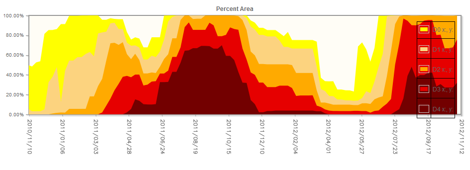
Oklahoma Drought Continues to Expand
With some areas of the state awaiting their first drop of rainfall since the end
of September and a wheat crop left thirsting for water in powdery dry soils,
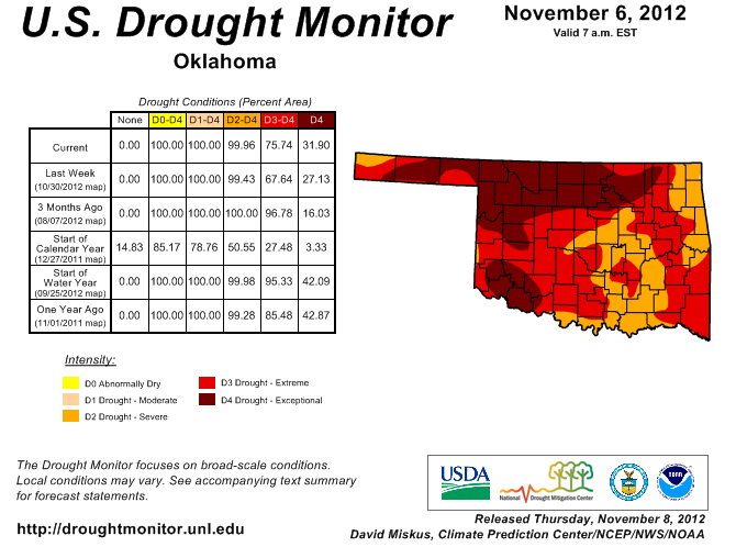
drought made yet another advance across Oklahoma according to the latest U.S.
Drought Monitor report. That report, released on Thursday morning, indicated an
eight percent increase in extreme-exceptional drought across the state, from 68
percent to 76 percent. Exceptional drought alone increased from 27 percent to 32
percent. The entire state remained in severe-exceptional drought. The Drought
Monitor?s intensity scale slides from moderate-severe-extreme-exceptional,
with exceptional being the worst category.
The lack of rainfall remained the main culprit, but strong winds and unseasonably
warm weather certainly contributed to the intensification. This type of rebound
is nothing new during a two year drought cycle in which relief has seemed to be a
?one step forward, two steps back? process. The last major improvement in the
state?s drought status occurred on Oct. 16 with a 14 percent drop in extreme-
exceptional drought, from 81 percent to 67 percent. The rain has stayed away
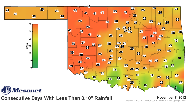
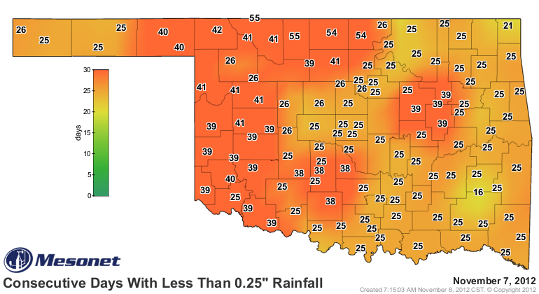
since then, however. According to data from the Oklahoma Mesonet, it has been
up to 55 days since parts of northern Oklahoma have seen a day with at least a
quarter of an inch of rainfall, and up to 41 days without a tenth of an inch.
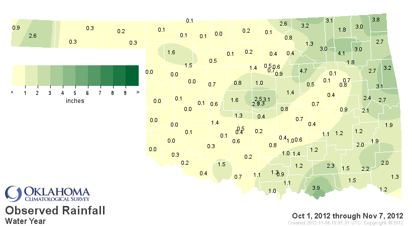
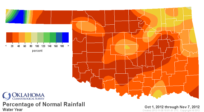
The state has seen an average of 1.1 inches of rainfall since October began to
fall more than 3 inches below normal and rank as the eighth driest Oct. 1-Nov.
8 since 1921. West central Oklahoma has barely had enough rain to wet the
gauge with an average of 0.11 inches, about four percent of normal over that
period.
This two-year drought cycle can trace its beginnings back to October 2010. The
dry weather extended through the spring of 2011 before exploding during the
brutal 2011 summer, the hottest on record for any state since records began in
1895. Widespread relief arrived in fall 2011, lasting through April 2012. The
rains stopped abruptly at that point and drought quickly made a comeback with
the aid of another hot, dry summer.
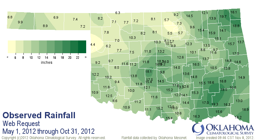
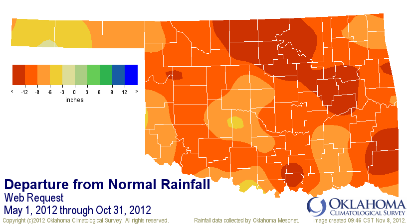
The May-October statewide rainfall deficit was nearly 11 inches, the second
driest such period in Oklahoma since records began in 1895. North central
Oklahoma?s average of 7.6 inches through that span was more than 13 inches
below normal and ranked as the driest since 1895.
The impacts to Oklahoma agriculture and water have been severe. The latest
?Oklahoma Crop Weather Report? from Oklahoma?s office of the USDA?s National
Agricultural Statistics Service finds 88 percent of the state?s topsoils and
94 percent of its subsoils rated in poor or very poor condition. One year ago,
those values were at 63 percent and 91 percent, respectively. The report also
noted 73 percent of the state?s pasture and rangeland in poor or very poor
condition. The portion of the Oklahoma wheat crop rated poor or very poor rose
from 12 percent to 30 percent over the last week. The damage done to the
topsoil became evident on Oct. 19 when strong winds lifted dust across
Interstate 35, dropping visibilities down to zero in a scene reminiscent of the
historical Dust Bowl storms. The shroud of dust caused a chain reaction wreck
of as many as three dozen vehicles. Eleven of the state?s major reservoirs are
at less than 70 percent of capacity, up from just three at the beginning of
May. Lake Altus is in the worst shape at 17 percent normal capacity. Canton
Lake, an important part of Oklahoma City?s water supply chain, is at 42
percent.

Rain is forecast for the weekend, arriving with a strong cold front. This
system does not appear to be a drought-breaker, however, although eastern
Oklahoma is expected to get up to a couple of inches of rain according to the
National Weather Service. Lighter amounts of less than a half of an inch are
forecast for western Oklahoma at this time.
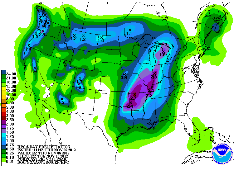
Looking farther ahead, another rain chance appears possible around the middle
of next week, although the timing remains uncertain. December, January and
February are normally the three driest months of the year in Oklahoma before
the rains pick up again during spring.
Gary McManus
Associate State Climatologist
Oklahoma Climatological Survey
(405) 325-2253
gmcmanus@mesonet.org
November 8 in Mesonet History
| Record | Value | Station | Year |
|---|---|---|---|
| Maximum Temperature | 92°F | FREE | 2006 |
| Minimum Temperature | 19°F | BOIS | 2000 |
| Maximum Rainfall | 3.96 inches | TALI | 2011 |
Mesonet records begin in 1994.
Search by Date
If you're a bit off, don't worry, because just like horseshoes, “almost” counts on the Ticker website!