Ticker for November 7, 2012
MESONET TICKER ... MESONET TICKER ... MESONET TICKER ... MESONET TICKER ...
November 7, 2012   November 7, 2012   November 7, 2012   November 7, 2012


Bad drought report cometh

Tomorrow's drought picture for Oklahoma will be worse than during the previous
month. The changes are a bit slower when you get into the cool season ... less
water stress involved with the cooler weather. The growing season ends and the
plants go dormant, we quit watering lawns and filling swimming pools. Some of you
quit showering (you know who you are). But drought can still worsen during the
cool season, of course. The continued lack of rainfall and periods of unseasonably
warm weather, not to mention the strong winds, have begun to take their toll once
again. We're still tracking the impacts on our stock ponds, lakes and reservoirs.
Not every body of water is suffering, but things are not looking good for some.
Here's a look at the current levels of Oklahoma's major reservoirs. I've thrown
in the change from one year ago and the change from one month ago.


Lake Altus continues as the worst in the bunch at 17% of capacity, pretty much
unchanged from last year at this time, but still going down. Others lakes such
as Hugo and Waurika have dropped considerably in the last month as well as in
the last year. Just by tracking the changing colors, however, you can see more
lakes headed downhill.

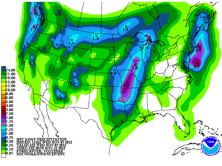
At least there is rain in the forecast! It doesn't look like much for the
western half of the state right now. Now I might now be the sharpest knife in
the shed (work with it), but I guarantee you that lakes and soil moisture won't
improve WITHOUT it in the forecast. Here's what the latest 5-day amounts look
like from the NWS' HPC.


As per usual, looks like eastern Oklahoma will get the best moisture. A half of
an inch or less in the western half, but maybe localized areas will get a good
shower or two. Until that time, and even afterward, the fire danger will
continue to be elevated (extreme at times). This is very much reminiscent of
the weather conditions we had going into November 2005, a very bad period for
fires.

One good dose of rain would definitely help that wheat crop across western
Oklahoma, especially in north central Oklahoma. A look at the latest departure
from average greenness map for the last week shows there's a lot of wheat seed
in the ground out there still waiting erupt. That's a similar picture all the
way to the Canadian border.


Gary McManus
Associate State Climatologist
Oklahoma Climatological Survey
(405) 325-2253
gmcmanus@mesonet.org
November 7 in Mesonet History
| Record | Value | Station | Year |
|---|---|---|---|
| Maximum Temperature | 95°F | HOLL | 2023 |
| Minimum Temperature | 18°F | BEAV | 2003 |
| Maximum Rainfall | 5.03″ | ELRE | 2011 |
Mesonet records begin in 1994.
Search by Date
If you're a bit off, don't worry, because just like horseshoes, “almost” counts on the Ticker website!