Ticker for November 9, 2012
MESONET TICKER ... MESONET TICKER ... MESONET TICKER ... MESONET TICKER ...
November 9, 2012   November 9, 2012   November 9, 2012   November 9, 2012


El Not

Well, it was fun while it lasted, and at least it gave us some hope for awhile.
I'm talking, of course, about the El Nino that wasn't (although looking at the
sea surface temperature (SST) anomalies in the equatorial pacific, it appears
we might have briefly had El Nino conditions). As we have been fearing, the
chances for El Nino have dropped considerably, enough that the CPC has
officially dropped its El Nino watch it first implemented back in the summer.

"ENSO-neutral is favored through the Northern Hemisphere winter 2012-13.
During October 2012, the Pacific Ocean continued to reflect borderline
ENSO-neutral/weak El Ni?o conditions. Relative to last month, the SST
model predictions more strongly favor ENSO-neutral, although remaining
above-average in the Ni?o-3.4 region through the Northern Hemisphere
winter 2012-13. While the tropical ocean and atmosphere may resemble a
weak El Ni?o at times, it is now considered less likely that a fully
coupled El Ni?o will develop. Therefore, the previous El Ni?o Watch has
been discontinued as the chance of El Ni?o has decreased. While the
development of El Ni?o, or even La Ni?a, cannot be ruled out during
the next few months, ENSO-neutral is now favored through the Northern
Hemisphere winter 2012-13."

So it appears we'll see SST anomalies sort of hover near the 0.5C mark that
indicates a transition into El Nino territory, but it probably won't get much
higher than that, nor will it couple with the air patterns that could help
sustain it.

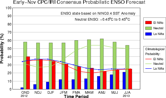
Here are the latest model results from the CPC/IRI (International Research
Institute for Climate) that the forecasters are using.


The green bars representing El Nino have overwhelmed the La Nina probabilities
(blue) and moved past the El Nino chances (red). It's a little concerning
that the La Nina chances are starting to rise as we get into the JJA (June,
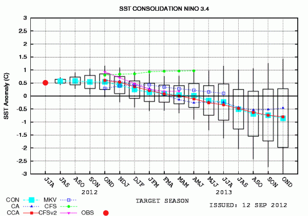
July and August) time frame next year. This whisker-plot shows the general
trend in the SST anomaly modeled output as we get into next fall and winter
sinking down into that La Nina area of -0.5C (the bright blue line with squares
is the consensus). The range (the black rectangle) on the output in that time
frame is between ENSO-Neutral and La Nina anomalies, so far far far from a
forecast yet.


At any rate, we have a longgggggg time to worry about next year's possible
ENSO state and whether or not it will even impact our weather here (which is
not always certain). We do know that this year's El Nino is highly unlikely now.
Hanging around with a weak El Nino isn't so great either, so getting it back
into ENSO-neutral would probably be a good thing.


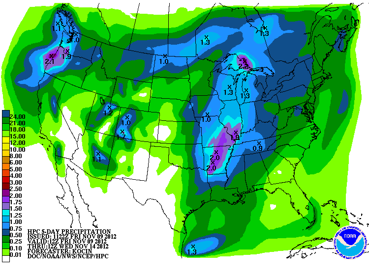
We still have this weekend's rain to fall back on for now. Still not seeing a
lot of rain for western Oklahoma, but any little bit would be greatly
appreciated, I'm sure.


After that, we need to get that train of storms rolling in like we had last
year at this time and enjoy some real relief.

Gary McManus
Associate State Climatologist
Oklahoma Climatological Survey
(405) 325-2253
gmcmanus@mesonet.org
November 9 in Mesonet History
| Record | Value | Station | Year |
|---|---|---|---|
| Maximum Temperature | 88°F | HOLL | 2012 |
| Minimum Temperature | 16°F | EVAX | 2018 |
| Maximum Rainfall | 2.04 inches | TALI | 2023 |
Mesonet records begin in 1994.
Search by Date
If you're a bit off, don't worry, because just like horseshoes, “almost” counts on the Ticker website!