Ticker for November 6, 2012
MESONET TICKER ... MESONET TICKER ... MESONET TICKER ... MESONET TICKER ...
November 6, 2012 November 6, 2012 November 6, 2012 November 6, 2012
Data data data!
Are you like me (go ahead, it's okay...I can't hear you)? Will you be sitting in
front of the computer today, checking out the newest data as it comes in, all the
latest results? Because yes, this weekend's rain chances are of the utmost
importance! Yeah, that was a dirty trick, but it fits with the season.
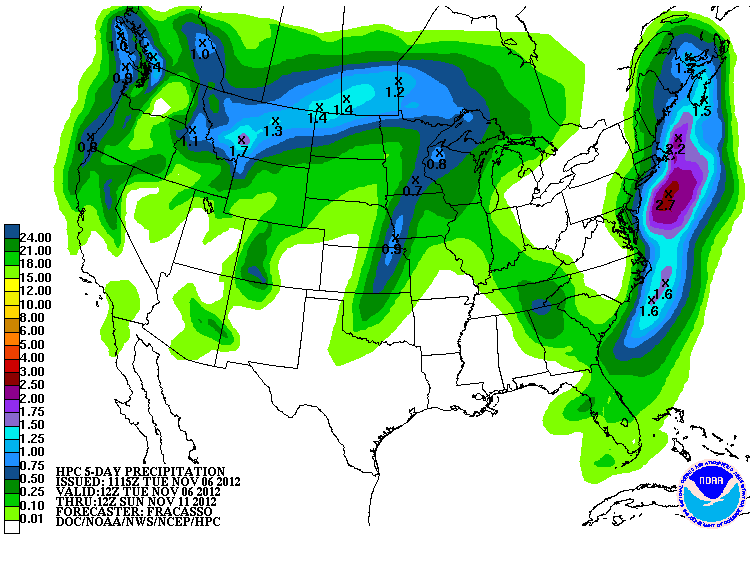
The newest data continues to paint Oklahoma with rainfall on Saturday into Sunday.
The latest 5-day amounts show more into western Oklahoma that previous runs,
indicative of a squall line forming along the cold front as it passes, perhaps.
Remember, this just goes through Sunday morning, so tonight's map should capture
the rest of the rain for that day.
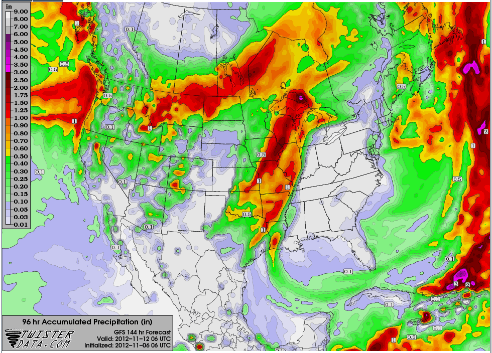
Some of the individual models through Sunday show a swath of about a half of an
inch to an inch across central and eastern Oklahoma. This would be bad news for
western Oklahoma, but there is still plenty of time for things to shift more to
the west.
I met quite a few folks yesterday that are desperate for rain. Cool season
grasses, wheat, canola and stock ponds all need a good drink of water. The
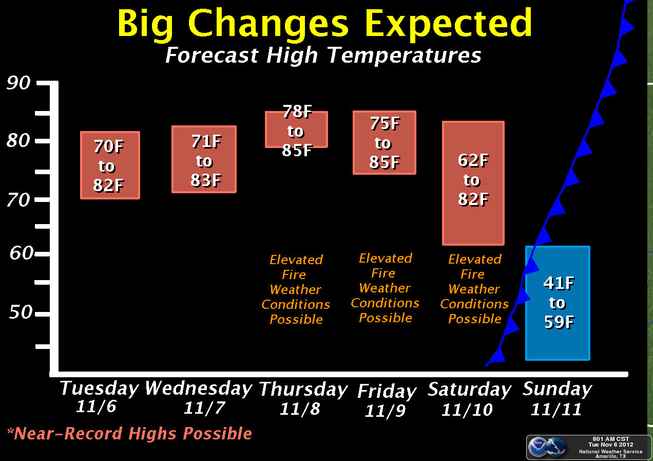
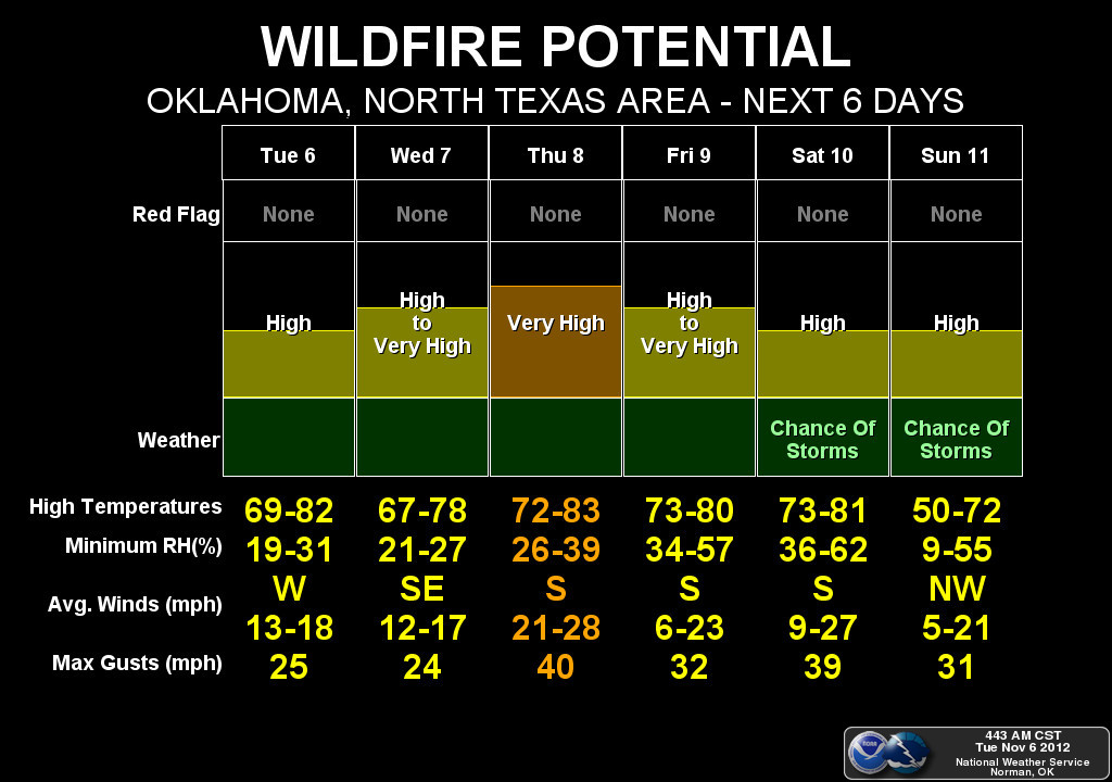
problem we will see before this rain is lots of wind, low relative humidity
and above normal temperatures. The perfect day-to-day weather conditions to
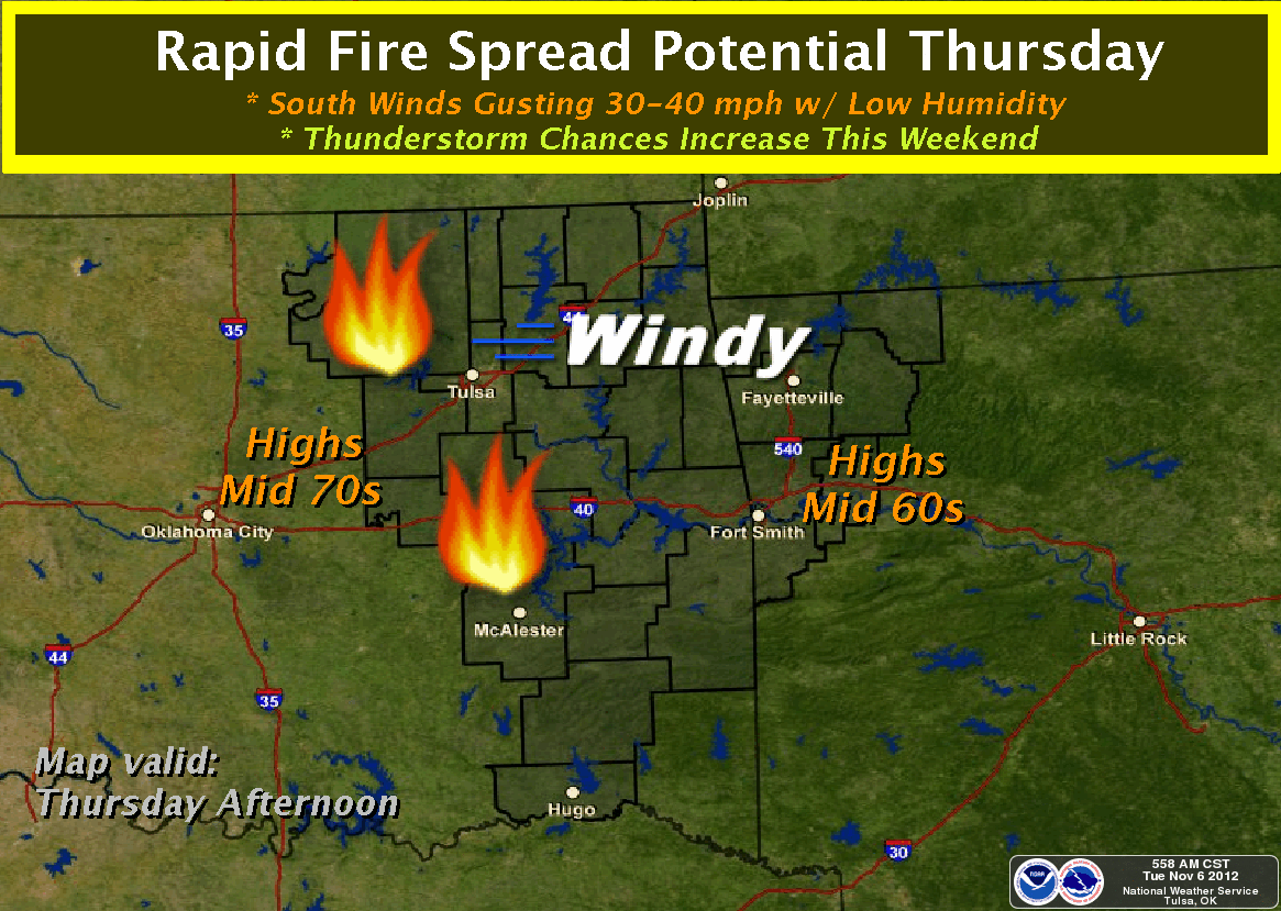
see an increase in fire danger. The Wednesday-Friday time frame looks pretty
potent in that regard. Here are the graphical representations of that from our
local NWS offices (by the way, I include Amarillo in this set since it covers
the most important part of the state, the Oklahoma Panhandle!).
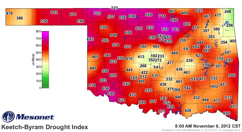
We're getting way too much purple and red on the Mesonet's Keetch-Byram map.
I've alway been a bigger Byram fan, come to think of it, so I'm renaming it the
Byram-Keetch map. At any rate, it's ugly. The Oklahoma Keetch-Byram Drought
Index (KBDI) illustrates the probability of wildfires based on drought and soil
moisture conditions throughout Oklahoma for the current day. It ranges from 0
(no drought) to 800 (extreme drought).
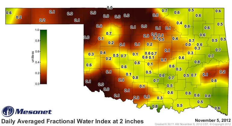
Beware of blowing dust this week with that wind. Silver lining, making lemonade
and all that, maybe the dust can put out any fires that flare up. The topsoils
are powder across much of western Oklahoma, particularly up in north central
sections.
The current water year (Oct. 1-to-current) continues to look nasty, with lots
of zeroes across western Oklahoma.
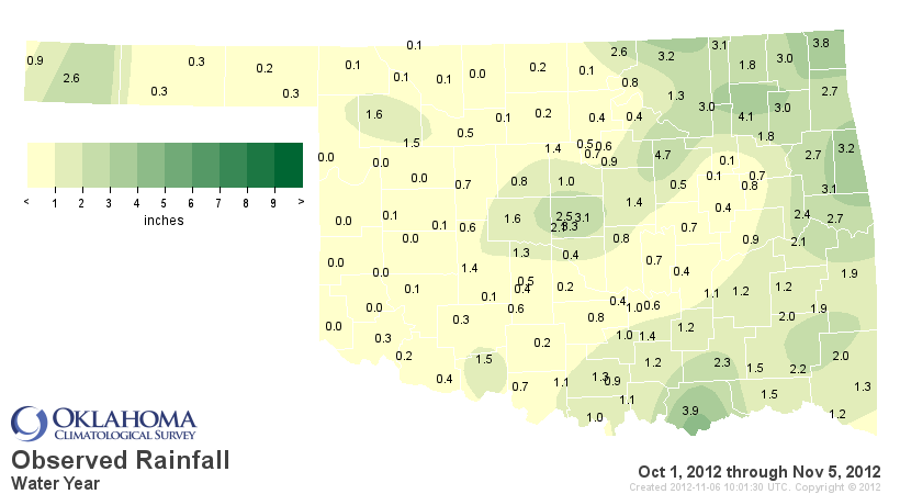
By my math, pretty sure 0.0 inches of rainfall equals out to 0.0 percent of
normal.
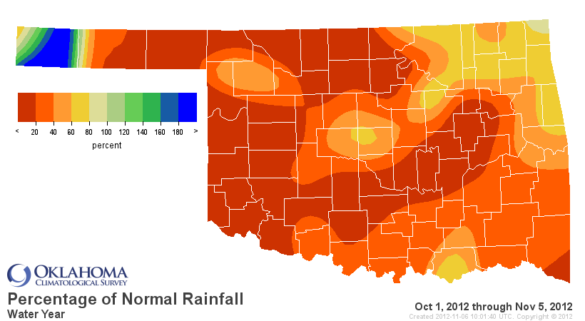
The state has had 1.1 inches of rain this water year, 2.75 inches below normal,
bad enough to rank as the ninth driest Oc1. 1-Nov. 6 on record, dating back
to 1921. We'll continue to watch and hope that this next storm system brings
some resolute changes. Or at least a drink of water.
I'm Gary McManus, and I do not approve of this drought.
Gary McManus
Associate State Climatological Pundit
Oklahoma Climatological Survey
(405) 325-2253
gmcmanus@mesonet.org
November 6 in Mesonet History
| Record | Value | Station | Year |
|---|---|---|---|
| Maximum Temperature | 89°F | BUFF | 2009 |
| Minimum Temperature | 19°F | GOOD | 2003 |
| Maximum Rainfall | 6.25 inches | RING | 2011 |
Mesonet records begin in 1994.
Search by Date
If you're a bit off, don't worry, because just like horseshoes, “almost” counts on the Ticker website!