Ticker for June 22, 2012
MESONET TICKER ... MESONET TICKER ... MESONET TICKER ... MESONET TICKER ...
June 22, 2012      June 22, 2012      June 22, 2012      June 22, 2012


El Nino forecast firms up

Now that we've come out of spring, the skill of the Sea Surface Temperature (SST)
forecast models that help to determine the ENSO state in the equatorial pacific
will continue to increase. Generally, whatever type of ENSO (El Nino, La Nina or
ENSO-Neutral) state that begins to develop will carry into the cool season.
While ENSO-Neutral conditions (SST anomalies within the +0.5C to -0.5C envelope)
currently exist, the momentum of warming towards an El Nino episode continues
to grow.

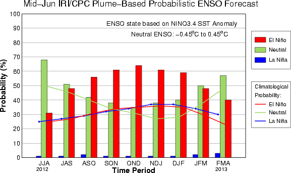
The latest output from the IRI/CPC ENSO prediction models greatly increase the
chances for El Nino development as we get into late summer and early fall.


The chances of ENSO-Neutral conditions persisting into the winter have dropped
dramatically since the last output in early June, and the chances for a three-peat
of La Nina are virtually nil. Here are those probabilities in table form. The
three letter identifiers represent 3-month periods (e.g., JJA = June, July and
August).

-****-
Mid-Month IRI Probabilistic ENSO Prediction for NINO3.4 Region Season
Season                La Ni?a 	      Neutral 	      El Ni?o
JJA 2012		1%		68%		31%
JAS 2012		1%		51%		48%
ASO 2012		2%		42%		56%
SON 2012		1%		38%		61%
OND 2012		1%		35%		64%
NDJ 2013		1%		38%		61%
DJF 2013		1%		40%		59%
JFM 2013		2%		50%		48%
FMA 2013		3%		57%		40%
-***-

Now there are some intricacies here. Most of the dynamic models are predicting
El Nino will develop while most of the statistical models favor ENSO-Neutral
conditions to continue. So there are still uncertainties. Recent research,
however, finds that the ECMWF (European Centre for Medium-Range Weather
Forecasts) dynamical model has shown superior skill over many of the other
models in recent times, and it clearly favors the development of at least a
moderate strength El Nino episode this winter.

-****-
ECMWF Nino 3.4 Region SST Anomaly Forecast (degrees C)
JJA 	JAS 	ASO 	SON 	OND
0+.6    +0.8	+0.9	+1.0	+1.2
-***-

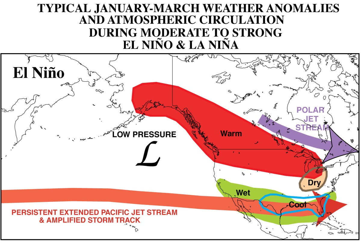
Here's a reminder of the possible (BUT NOT CERTAIN) cool season impacts of El
Nino for the North American continent.


Now we have to be careful here and not try and interpret that figure as "Cold
and wet? Get ready for more snow!" While the last El Nino period during the
winter of 2009-10 turned out to be quite the winter wonderland here in Oklahoma
and across the South, there were many more factors that played into that season
(the Arctic Oscillation, the North Atlantic Oscillation, etc.). What we can
hope for, however, is a general turn of the pattern away from the dry and warm
regime that has dominated the Southern Plains over the last couple of years to
perhaps a more favorable (debatable) cool and wet one. Always remembering that
other factors can influence the influence of ENSO, and that the impacts are
normally more potent to the south and east of Oklahoma.


Gary McManus
Associate State Climatologist
Oklahoma Climatological Survey
(405) 325-2253
gmcmanus@mesonet.org
June 22 in Mesonet History
| Record | Value | Station | Year |
|---|---|---|---|
| Maximum Temperature | 104°F | TIPT | 1998 |
| Minimum Temperature | 49°F | BOIS | 2004 |
| Maximum Rainfall | 4.73″ | MANG | 1999 |
Mesonet records begin in 1994.
Search by Date
If you're a bit off, don't worry, because just like horseshoes, “almost” counts on the Ticker website!