Ticker for June 21, 2012
MESONET TICKER ... MESONET TICKER ... MESONET TICKER ... MESONET TICKER ...
June 21, 2012 June 21, 2012 June 21, 2012 June 21, 2012
Drought, just in time for the REAL summer heat
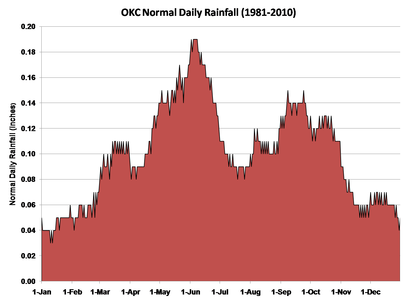
We're past the primary rainy season in most of Oklahoma (for an example, check
out this graph of normal (1981-2010) daily rainfall for Oklahoma City).
There's lots of talk of an extended heat wave on tap beginning next week
Hey, it's Oklahoma. Nothing unexpected there. Unfortunately, the U.S. Drought
Monitor map released this morning shows some ominous new colors in parts of the
state, a consequence of both short- and long-term dry conditions.
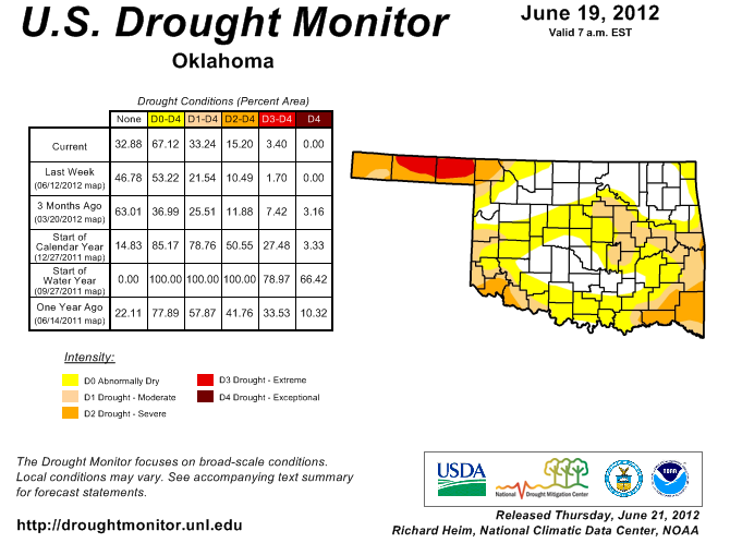
Extreme (D3) drought has once again moved east in the Oklahoma Panhandle, now
covering much of Beaver County. Drought also intensified in eastern Oklahoma.
Severe (D2) drought now covers much of the extreme southeast, and moderate (D1)
drought has crept into east central Oklahoma as far east as Payne and
Seminole counties.
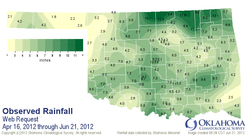
If you consider mid-April through mid-June (see above example) as the primetime
rainy season in Oklahoma, ratings are way down this year. In fact, dating back
to 1921, this April 16-June 21 is the third driest in that period based on a
statewide average of 5.72 inches. That's more than 4 inches below normal, or
59% of normal.
April 16-Jun 21 Mesonet Rainfall Maps
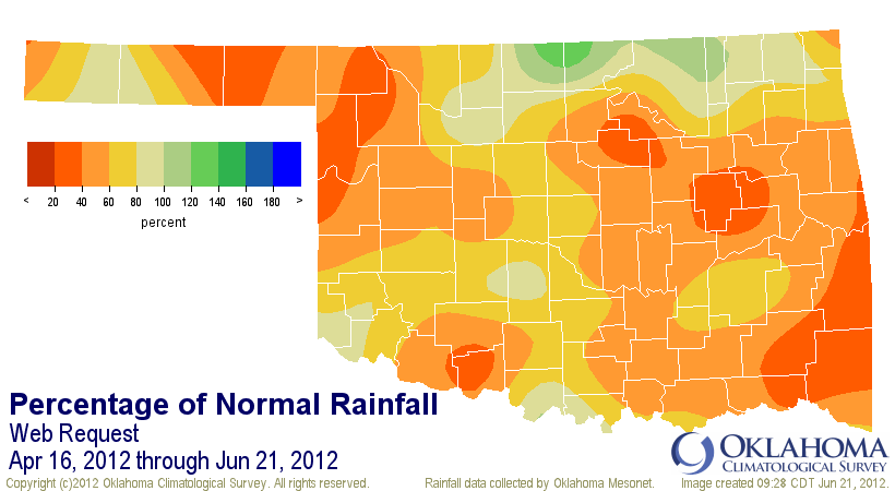
Yikes! That percent of normal map is pretty ugly, and a good indication of why
the impacts of drought are gaining. And it comes at a very inopportune time,
just as the heat wave looms on the horizon. As I've said many times, you do not
want to go into the summer months with a drought either in place or developing.
The demands from evaporation and transpiration (hey, evapotranspiration!)
simply cannot keep up with our "normal" precipitation amounts. The two can then
feed off of each other, with drought begetting heat, and heat begetting more
drought ... and so on and so forth.
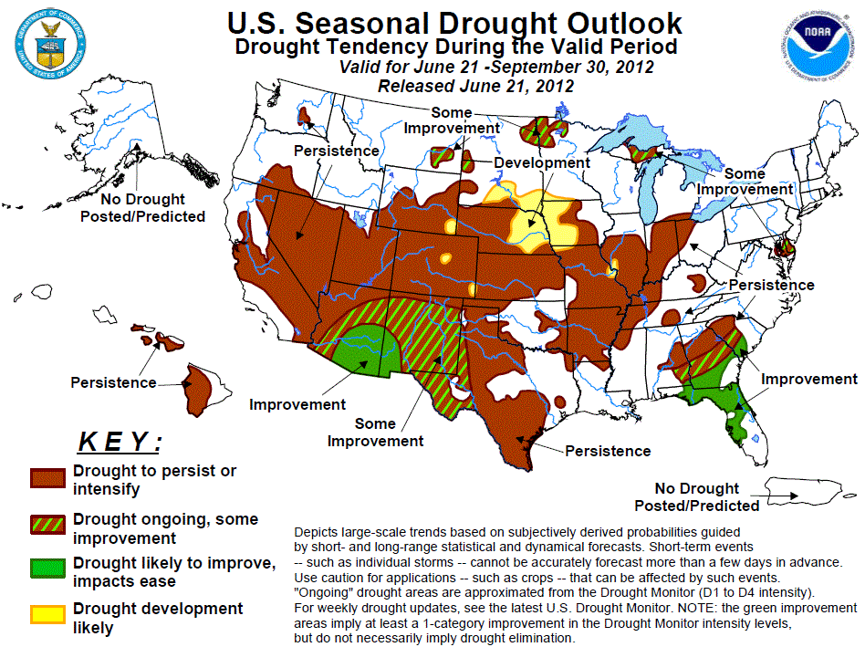
The latest U.S. Seasonal Drought Outlook sort of touches on that with its
release this morning. It does indicate that the drought that's already developed
across the state is expected to either persist or intensify through September.
But at least it does not show expected drought development in those areas
currently without drought.
That's all well and good, but if we go into an extended heat wave with little
rainfall, all bets are off at that point. But it is very difficult to predict
summer rainfall patterns (other than just "it's summer, it doesn't rain much").
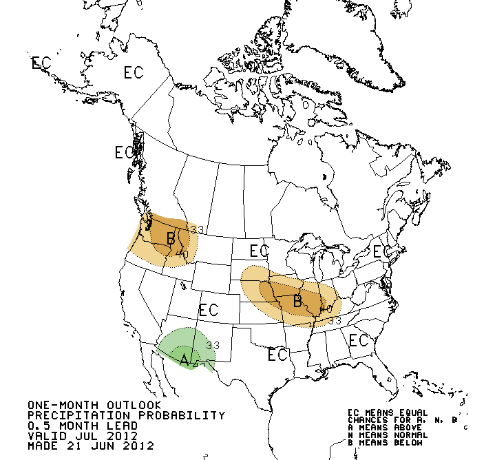
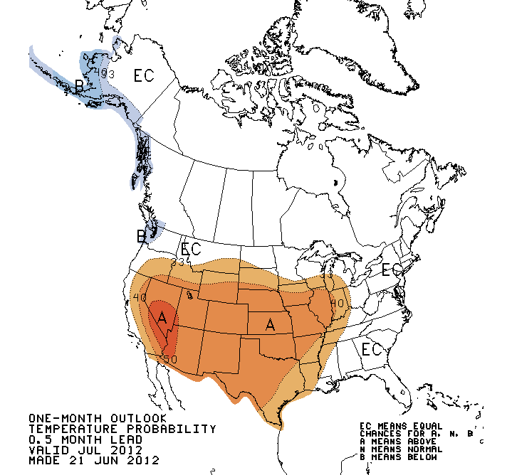
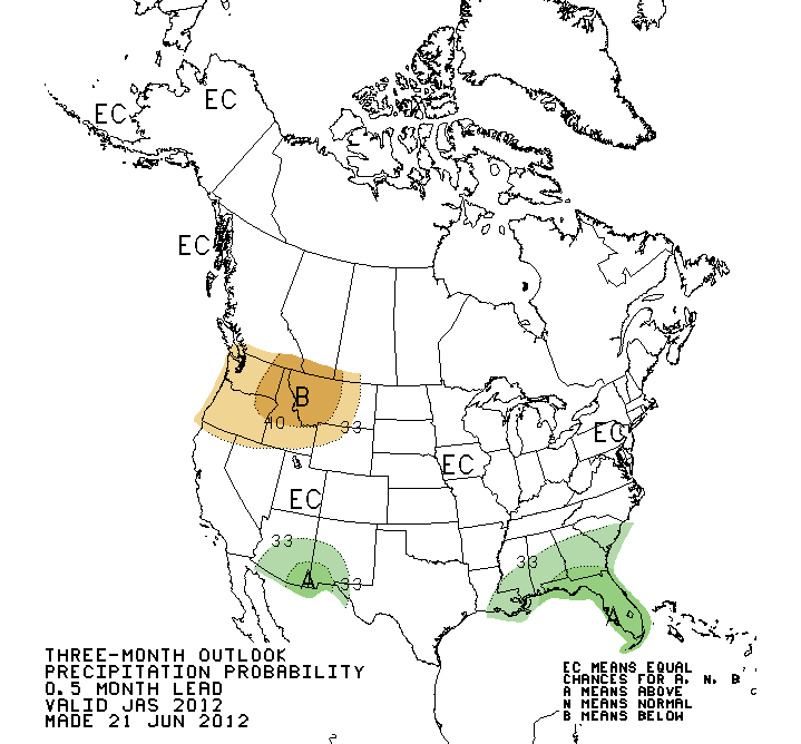
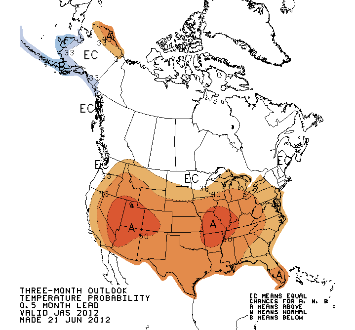
The latest outlooks for July and July-August from the CPC are fairly confident
on temperatures, but lack any sort of guidance for precipitation. They show
increased odds of above normal temperatures across much of the U.S., including
Oklahoma, for both periods. Please remember that the "EC" depicted in the
precip outlooks are not an expectation of "normal" but an indication of the lack
of skill in making any determination for that period. A clever way to say "we
don't know."
July
July-September
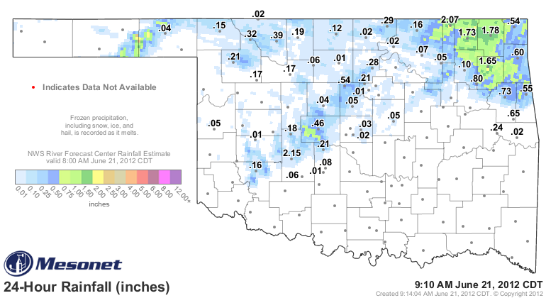
For some good news, it's raining as I type this! A couple of areas of rain are
moving through the state. The northeast has gotten the highest totals thus far.
I'll leave ya with a bit of heatwave-related trivia. The first 100 degree day
(on its way to a then-record 50 days) at OKC back in the heat wave of 1980
didn't occur until June 25. In fact, the highs at OKC on June 20-22 were 89,
86 and 86 degrees, respectively.
Just sayin'.
Rainy season is past. We now throw ourselves on the mercy of summer.
Yikes!
Gary McManus
Associate State Climatologist
Oklahoma Climatological Survey
(405) 325-2253
gmcmanus@mesonet.org
June 21 in Mesonet History
| Record | Value | Station | Year |
|---|---|---|---|
| Maximum Temperature | 107°F | HOLL | 1998 |
| Minimum Temperature | 52°F | KENT | 2004 |
| Maximum Rainfall | 6.57″ | COOK | 2000 |
Mesonet records begin in 1994.
Search by Date
If you're a bit off, don't worry, because just like horseshoes, “almost” counts on the Ticker website!