Ticker for June 8, 2012
MESONET TICKER ... MESONET TICKER ... MESONET TICKER ... MESONET TICKER ...
June 8, 2012       June 8, 2012       June 8, 2012       June 8, 2012


El Nino Watch Issued by the Climate Prediction Center

The National Weather Service's Climate Prediction Center has issued an El Nino
watch for this coming cool season. This watch indicates conditions are favorable
for the development of El Nino within the next six months. The double-dip La Nina
event that we have seen the last two cool seasons faded completely in April,
leaving Sea Surface Temperatures (SST) in the equatorial pacific at near normal
levels, indicating ENSO-Neutral conditions currently prevail. A majority of the
latest SST computer models predict ENSO-Neutral conditions to continue through
the June-August season. As we get farther into the cool season, however, the
computer models are split between the formation of an El Nino event or the
continuation of ENSO-neutral conditions. In the Climate Prediction Center's
estimation, the current chances of an El Nino event are around 50 percent.


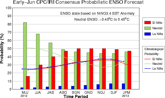
This table defines the statistical probabillities of the modeled output:

-****-
Season	     La Ni?a    Neutral  El Ni?o
MJJ 2012	2%	  82%	   16%
JJA 2012	2%	  68%	   30%
JAS 2012	3%	  57%	   40%
ASO 2012	4%	  49%	   47%
SON 2012	4%	  46%	   50%
OND 2012	5%	  45%	   50%
NDJ 2013	6%	  44%	   50%
DJF 2013	7%	  44%	   49%
JFM 2013	7%	  46%	   47%
-***-

One thing is for certain, the chances of La Nina development for the third
straight cool season are extremely low. That side of the El Nino/Southern
Oscillation (hence, the ENSO acronym) helped, in combination with other
factors, to give Oklahoma and the U.S. warmer than normal conditions over
the last couple of years.

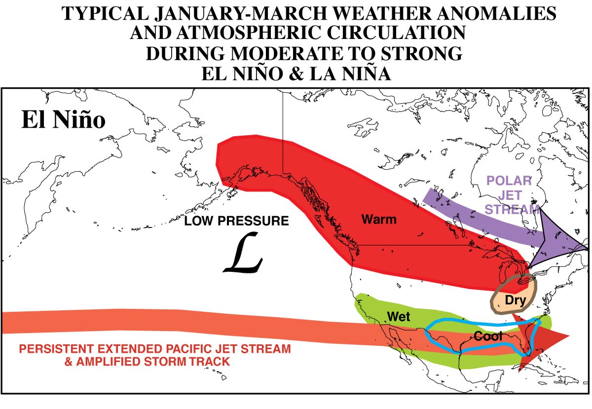
So what would El Nino mean for Oklahoma? Well, just as with La Nina, nothing
for certain. What it does do, however, is tip the odds in favor of a bit of a
cooler and wetter cool season (October-March).


The impacts on Oklahoma are a bit muted as compared to parts farther south and
east than us, but just as with La Nina, it can impact our weather. The strength
of the El Nino seems to matter, which the moderate and strong events having
more of an impact.

The forecast models will solidify their predictions as we go through the
summer. Nothing to worry about, of course, but any help reducing our chances
for drier than normal weather for the next cool season will be a good thing.

Gary McManus
Associate State Climatologist
Oklahoma Climatological Survey
(405) 325-2253
gmcmanus@mesonet.org
June 8 in Mesonet History
| Record | Value | Station | Year |
|---|---|---|---|
| Maximum Temperature | 107°F | FREE | 2011 |
| Minimum Temperature | 38°F | BOIS | 2007 |
| Maximum Rainfall | 5.42″ | ALVA | 1995 |
Mesonet records begin in 1994.
Search by Date
If you're a bit off, don't worry, because just like horseshoes, “almost” counts on the Ticker website!