Ticker for June 14, 2012
MESONET TICKER ... MESONET TICKER ... MESONET TICKER ... MESONET TICKER ...
June 14, 2012 June 14, 2012 June 14, 2012 June 14, 2012
Heat update
No no no, not THAT Heat. I'm about worn slick by all the NBA/Weather quips, so I
won't add to the wretched excess. Let's talk about the weather version instead.
One year ago today, Oklahoma City recorded its first triple-digit temperature
of 2011 when it reached 100 degrees. We're referring to the official observing
station at Will Rogers Airport. That was the first of 11 during June as OKC was
on its way to 63 days for the year. That easily topped the previous record of
50 days above 100 degrees back in 1980. How does that compare to this year?
Check out THESE quips!
* OKC hit their first triple digit high temp on June 14 of last year. The high
last year on this date was 100 degrees exactly.
* OKC ended up with highs of at least 100 degrees 11 times during June 2011, on
its way to 63 for the year (a record for OKC...previous was 50).
* Oklahoma City's high temperature thus far in 2012 is 92 degrees on May 28
(through June 13)
* Oklahoma City has reached 90 degrees six times in 2012 thus far (through June
13)
* OKC reached 90 degrees 23 times through the same period (Jan 1-Jun 13) in 2011
Wow! What a difference a year makes. What about statewide? And we have some nice
maps to go with this one. Remember, we're comparing the Jan 1-Jun 13 periods from
2011 and 2012.
* Only the southwest corner of the state has seen prolific triple digit
temperatures thus far in 2012
* Altus leads the state with 13
* Same period in 2011, SW OK had from 16-21 days, with Grandfield leading the
way
* Triple-digit temperatures had been occurring all throughout western Oklahoma
* The days above 90 degrees are similar but this year is starting to fall
behind last year's pace
* Only SE OK is ahead of last year's pace, but they are one of the few regions
of the state that is drier now compared to last year (remember that eastern
Oklahoma was fairly wet last April and May)
90 degree days (Jan 1-Jun 13)
2011 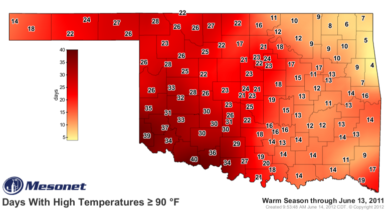
2012 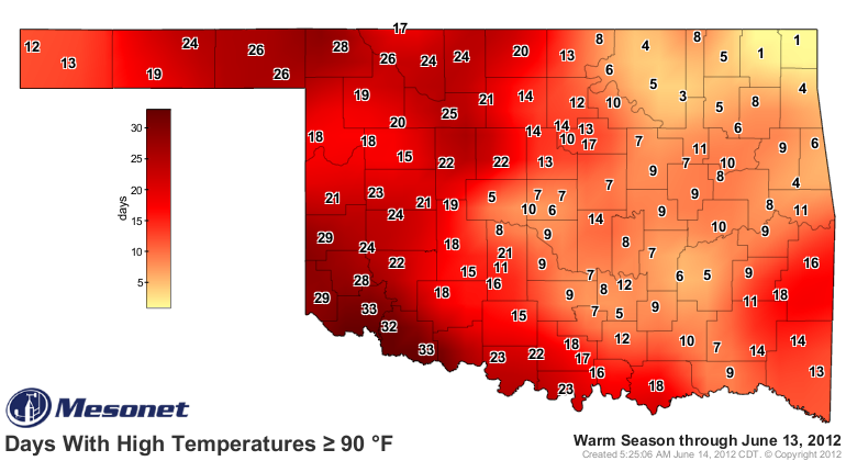
100 degree days (Jan 1-Jun 13)
2011 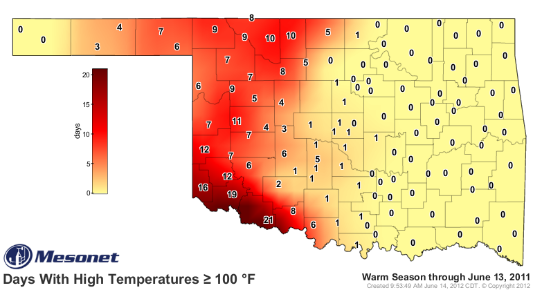
2012 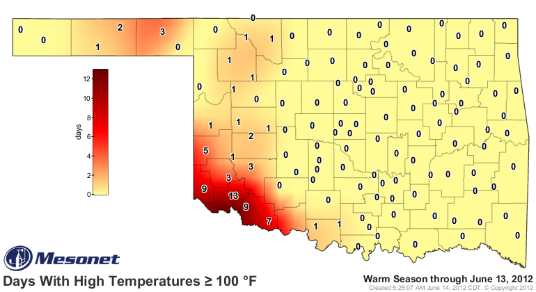
The difference between the first one-sixth or so of summer (climatological
summer runs from June 1-August 31) this year vs. last year is not even close.
Check out these stats!
Statewide Average Temperatures (June 1-13)
Year Tmax Tmin Tavg
2011 95.1 69.2 82.2
2012 87.1 63.0 75.1
Normal 86.0 63.1 74.6
So we have been just a bit above normal this year during June, but nowhere even
close to last year. And last year's June ended up the second warmest on record
for the state (dating back to 1895) with a statewide average temperature
of 83.6 degrees.
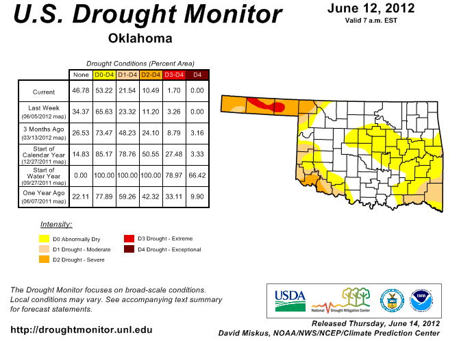
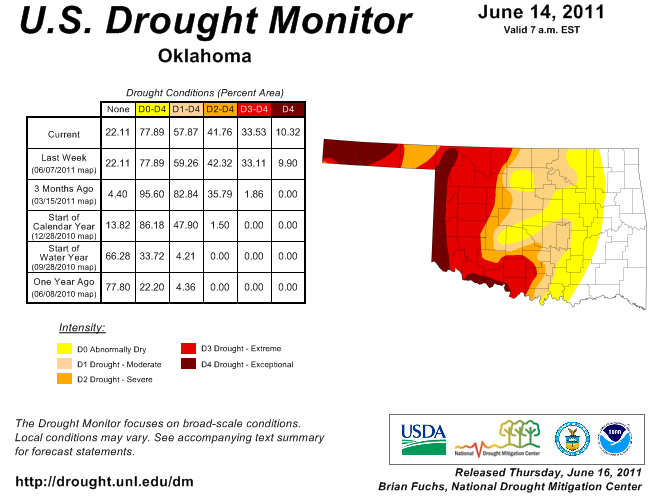
The difference between the two years is obvious. The drought situation now is
night/day vs. last year.
U.S. Drought Monitor Map (June 12, 2012)
U.S. Drought Monitor Map (June 14, 2011)
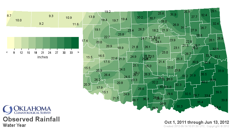
And the reason for that is obvious as well, looking at the rainfall stats for
each water year (Oct 1-Jun 13)
Oct 1, 2011-Jun 13, 2012 (36th wettest dating back to 1921)
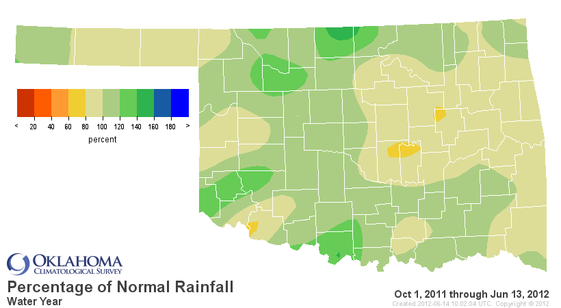
Oct 1, 2010-Jun 13, 2011 (6th driest since 1921)
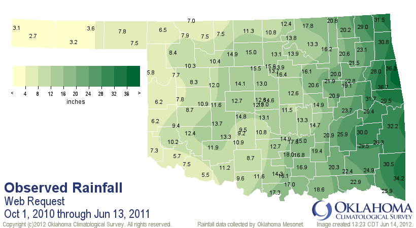
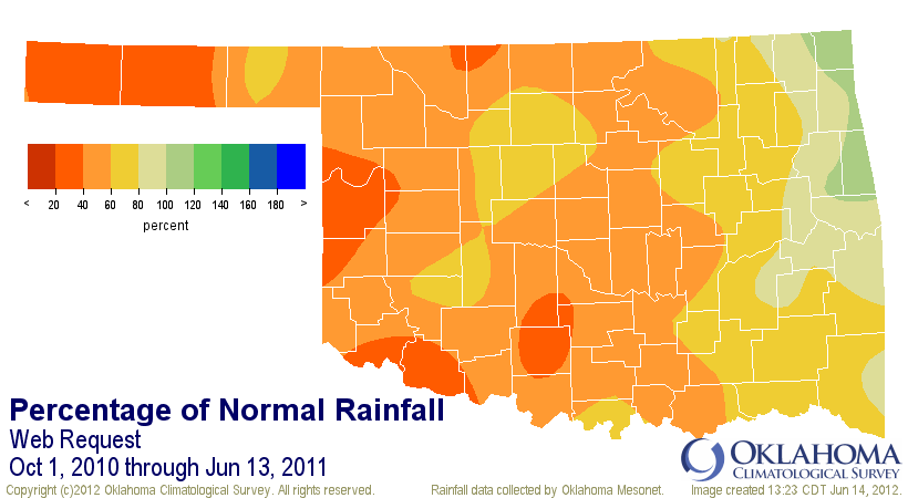
So the conditions, especially the extreme heat-drought feedback loop that
fed both last year, have simply not been ripe for extreme heat so far this
summer. We have seen record-setting warmth during 2012. Our Spring, Jan-May and
March temperatures all broke all-time records. But as we've discussed many times
in previous Tickers, that does not automatically equate to extreme summer heat.
That answer lies in our summer rainfall patterns.
One note of caution: while our rains have been much more plentiful over much
of the state, we are still drying out in some areas, particularly southeastern,
eastern and northwestern Oklahoma.
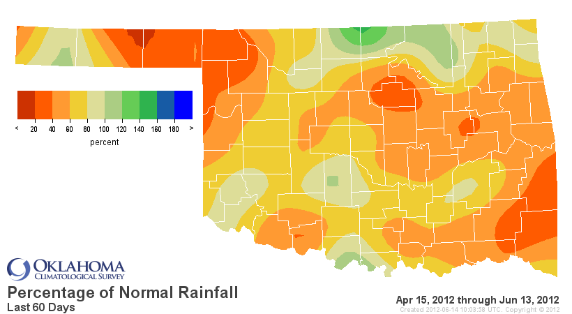
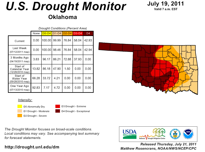
And while the drought picture does not look bad now, remember the DM from this
time last year shown above and then look at where it was a month and two
months later.
U.S. Drought Monitor July 19, 2011
U.S. Drought Monitor August 16, 2011
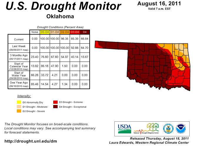
Even the drought and associated heat picture can change fairly quickly during
the height of summer. Look to the rains. They will play a large part in our
100-degree fate.
Besides, until the Heat gets up to 105, it's not even worth talking about,
right?
(Whew, been holding that one in. Wretched excess continues)
Gary "Fear the Beard" McManus
Associate State Thunderologist
Oklahoma NBA Champions Survey
(405) 325-2253
gmcmanus@mesonet.org
June 14 in Mesonet History
| Record | Value | Station | Year |
|---|---|---|---|
| Maximum Temperature | 108°F | GRA2 | 2011 |
| Minimum Temperature | 42°F | BOIS | 2001 |
| Maximum Rainfall | 11.26″ | OKCN | 2010 |
Mesonet records begin in 1994.
Search by Date
If you're a bit off, don't worry, because just like horseshoes, “almost” counts on the Ticker website!