Ticker for June 4, 2012
MESONET TICKER ... MESONET TICKER ... MESONET TICKER ... MESONET TICKER ...
June 4, 2012 June 4, 2012 June 4, 2012 June 4, 2012
Potpourri
Skia(took) a beating last night
Between 11:10 p.m. and 2:00 a.m. last night, the Oklahoma Mesonet site at
Skiatook measured 5.91 inches of rainfall ... around 6 inches in about three
hours, to be exact.
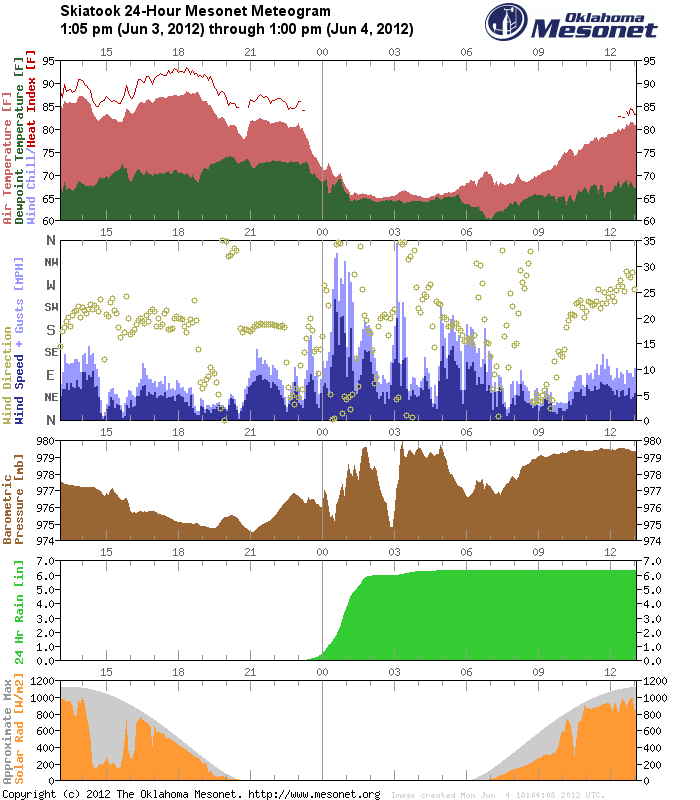
The 100-year 3-hour rainfall maximum for the Skiatook area is estimated by one
effort as around 5.5 inches and the 500-year event is approximately 7 inches.
In other words, that's a boatload of rain in just three hours time! This is a
continuation of a very disjointed rain pattern we've been seeing over the last
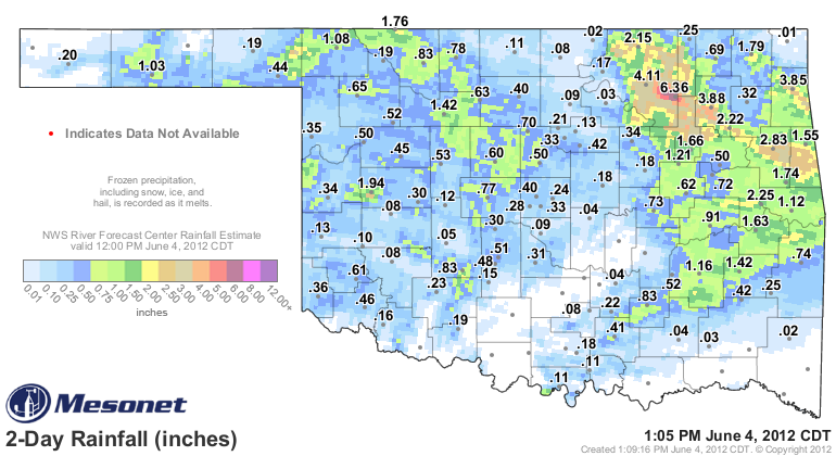
two weeks or so. Here are the totals from the last couple of days. Unfortunately,
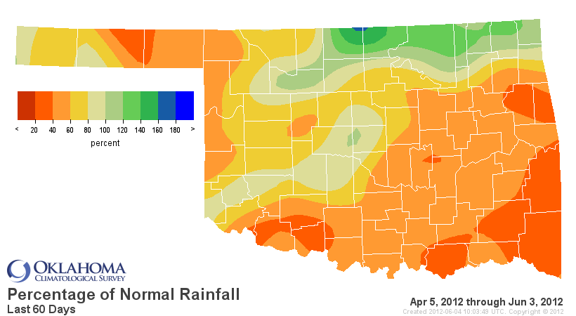
southern Oklahoma missed out once again and they remain teetering on drought,
waiting to topple with each hot, rainless day.
There are still chances for rain over the next few days, at least from what I
have seen from my friends at the NWS. That rain definitely needs to shift south
in order to alleviate those growing-shortages-by-the-day shortages in southern
and parts of western Oklahoma.
-------------------------------------------------------------------------------
Speaking of lakes (just play along), the heat and lack of rainfall is really
starting to play havoc on those in southern Oklahoma. A few others have never
had a chance to recover from last year's drought.
This is from some information OCS sent to the U.S. Drought Monitor folks
this morning concerning lake levels.
"Along the Canadian basin, Canton (Blaine County) is still struggling
at 56% of conservation pool. Thunderbird (Cleveland County / Norman)
is still on our watch list at 88%. Other lakes along the Canadian
seem to be doing well.
The Red River is showing more stress. Far southwest, Altus and Tom
Steed are essentially unchanged and unusable since last fall.
Waurika (Cotton County) is bordering our critical list at 70%,
continued slight drop of 2% in the last month and 6% for the water
year. Texoma, one of Oklahoma's largest reservoirs, popped up on
our watch list this week, dropping to 89%, dropping 8% in the last
two weeks and 15% for the month (had been in flood pool a bit).
Hugo (Choctaw County), Pine Creek (McCurtain) and Broken Bow
(McCurtain) have also been dropping steadily at 10-11% in the past
month; they are on our watch list but not yet close to critical
(83%, 88% and 88%, respectively). Arbuckle (Murray), McGee Creek
(Atoka) and Sardis (Pushmataha) are still full."
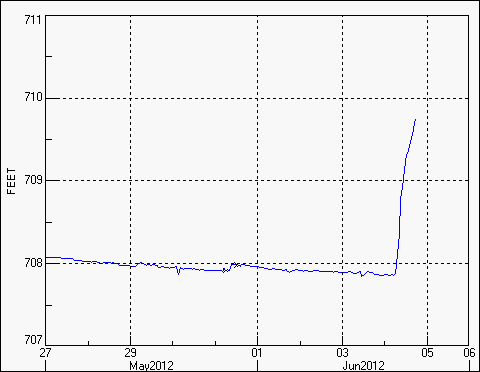
Now the good news is at Lake Skiatook, of recent gullywasher fame, where the
level rose about 2 feet with the latest rains. It should continue to rise as
more of that rain makes its way to the lake.
Lake levels normally drop during the summer as evapotranspiration and
consumptive demands far outpace precipitation. Doesn't always have to work that
way, but it usually does. We need to replenish those lakes before we get into
July or August.
-------------------------------------------------------------------------------
Will summer be a nightmare?
Well, to roughly paraphrase the ghostly Captain Barbossa from "Pirates of the
Caribbean": We best start believing in nightmares, because some of us are
in one! Southwestern Oklahoma has already had locations with high temperatures
at or above 100 degrees 12 times through June 3 this year.
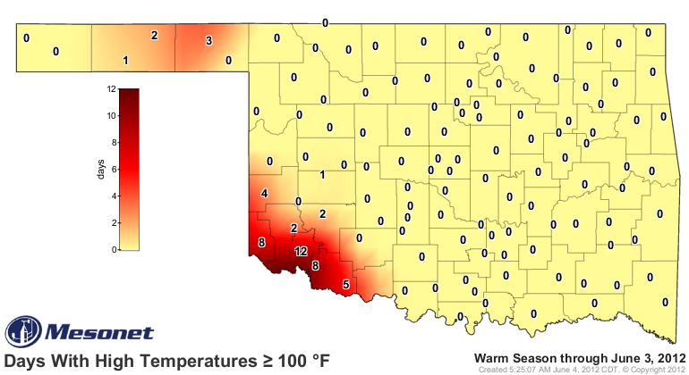
Altus, apparently angered over Grandfield's 2011 all-time state record 101 days
above 100 degrees, has decided to get a jump-start on its fiery foe across the
Jackson/Tillman county line. That area still resides in severe drought, and
the red of extreme drought from northwest Texas continues to creep
northeastward. More extreme heat is surely in their future if rain does not
arrive soon. Through June 3 last year, Altus had only reached 100 degrees 10
times. If it makes you feel better, Grandfield had 11 at this time last year
and only has eight this year.
Only 11 of the 120 Mesonet stations have reached 100 degrees so far in 2012
whereas 33 had at this time last year, so the extreme heat is not as widespread,
especially across the western half of the state.
Gary McManus
Associate State Climatologist
Oklahoma Climatological Survey
(405) 325-2253
gmcmanus@mesonet.org
June 4 in Mesonet History
| Record | Value | Station | Year |
|---|---|---|---|
| Maximum Temperature | 107°F | GRA2 | 2014 |
| Minimum Temperature | 43°F | EVAX | 2025 |
| Maximum Rainfall | 8.23″ | GRAN | 1995 |
Mesonet records begin in 1994.
Search by Date
If you're a bit off, don't worry, because just like horseshoes, “almost” counts on the Ticker website!