Ticker for June 1, 2012
MESONET TICKER ... MESONET TICKER ... MESONET TICKER ... MESONET TICKER ...
June 1, 2012 June 1, 2012 June 1, 2012 June 1, 2012
May Ends Warmest Spring in Oklahoma History
A pleasantly cool final day and scattered heavy rains during the month?s final
week were too little and too late, and May entered the record books as one of the
warmest and driest in state history. According to data from the Oklahoma Mesonet,
the statewide average temperature finished at 72.2 degrees, 4.3 degrees above
normal. That ranks May as the fifth warmest on record. Statewide average records
date back to 1895. That heat, combined with the state?s warmest March and tenth
warmest April, propelled the spring season to the warmest on record at 65.1
degrees, 6 degrees above normal. The climatological spring runs from March
through May for record purposes. The previous record mark for spring was 62.9
degrees from 2006. The January-May statewide average of 56.3 degrees also tops
the record books at 5.2 degrees above normal.
May Temperatures
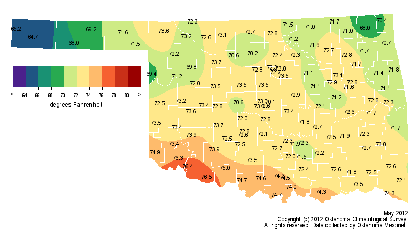
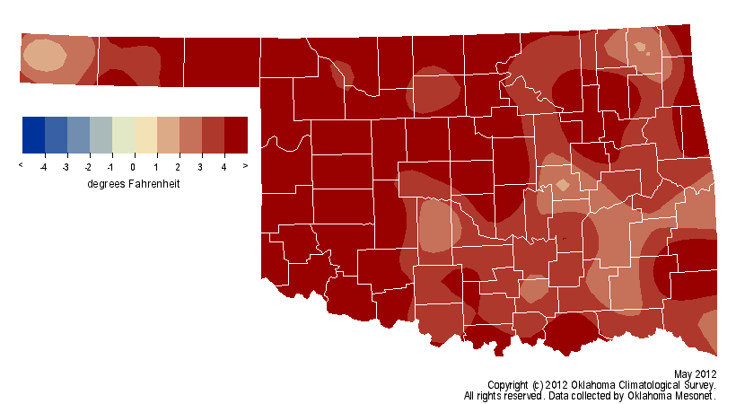
The recent warmth is a continuation of what the state has experienced since early
2010. Of the last 26 months, starting with April 2010, 21 have been warmer than
normal. Three of the last 11 months (July and August, 2011, and March 2012) and
two out of the last four seasons (summer 2011 and spring 2012) eclipsed their
respective all-time heat records as well. June 2011 barely missed that month?s
top mark, settling for the rank of second warmest. Oklahoma?s July and summer
statewide average temperatures in 2011 were record marks for the United States
as well. There were blasts of wintry revenge during that period, of course.
Oklahoma saw its all-time lowest minimum temperature and 24-hour snowfall
records fall in February 2011. Just prior to the string of warm months, the
winter of 2009-10 finished as the eighth coldest ? and one of the snowiest ? on
record at more than 4 degrees below normal.
https://content.mesonet.org/ticker/archive/20120601/2010-12-monthly-temps.pdf
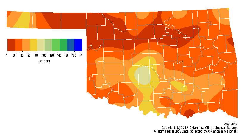
Scattered heavy rainfall at the end of the month helped May to avoid becoming
the driest on record and finished with the rank of fourth driest. The statewide
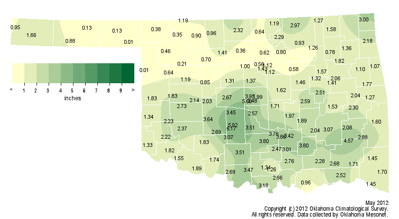
average precipitation total was 1.8 inches, 3.4 inches below normal. Rainfall
totals from the Mesonet ranged from around 6 inches in Grady County to a dusty
0.01 inches from both Arnett and Slapout. Much of the northern third of the
state had trouble keeping the rain gauge wet and recorded less than an inch for
the month. Drought relief that began last fall faded in the dry, hot weather of
April and May for some areas. The latest U.S. Drought Monitor report, released
on May 31, finds moderate drought creeping back into eastern Oklahoma from
Arkansas. A broader area of ?abnormally dry? conditions, a drought pre-cursor,
covered much of eastern and southern Oklahoma. The Panhandle and southwestern
Oklahoma continue with drought conditions labeled from ?moderate? to ?extreme.?
May Rainfall
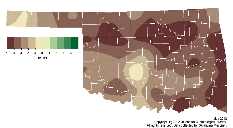
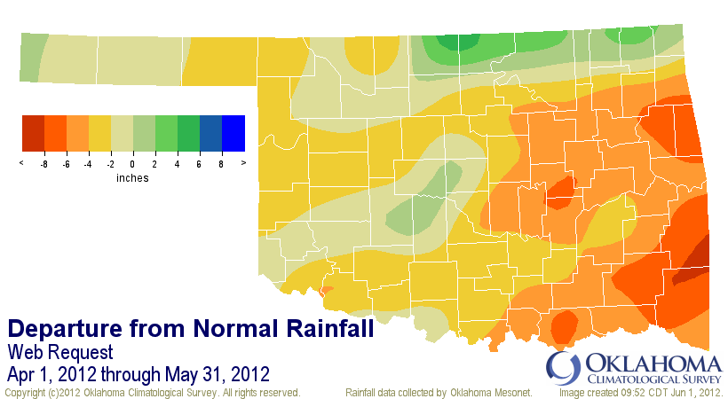
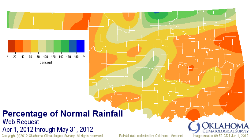
April-May Rainfall

Despite the violent weather during its last week, May was actually one of the
quietest on record for tornadoes. Preliminary numbers from the National Weather
Service (NWS) estimate May?s total at three. While that number could still
rise, it would not be by much. May 2010 had a record-tying 90 tornadoes and
May 2011 had 46. The preliminary total for the year currently stands at 51.
The average tornado count for May is 22 and the annual average is 55. Accurate
tornado statistics date back to 1950.
The latest outlooks from the NWS? Climate Prediction Center for both June and
the summer months of June through August continue to indicate increased chances
for above normal temperatures in Oklahoma and much of the southern United
States. There are no clear signals for the state on what to expect for
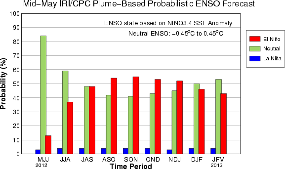
precipitation, however. Past that period, there are suggestions that an El Ni?o
event could develop in the fall. That phenomenon, characterized by warmer than
normal waters in the equatorial pacific, can bring cooler and wetter weather
during winter to the southern tier of the United States, including Oklahoma.
The last two winters have seen La Ni?a events enhance Oklahoma?s chances for
warmer and drier weather.
Link to June outlooks from the Climate Prediction Center
http://www.cpc.ncep.noaa.gov/products/predictions/30day/
Link to Summer (June-August) outlooks from the CPC
http://www.cpc.ncep.noaa.gov/products/predictions/long_range/seasonal.php?lead=1
IRI-CPC ENSO Forecast
Gary McManus
Associate State Climatologist
Oklahoma Climatological Survey
(405) 325-2253
gmcmanus@mesonet.org
June 1 in Mesonet History
| Record | Value | Station | Year |
|---|---|---|---|
| Maximum Temperature | 110°F | ALTU | 1998 |
| Minimum Temperature | 44°F | OILT | 2012 |
| Maximum Rainfall | 6.51″ | OKEM | 2013 |
Mesonet records begin in 1994.
Search by Date
If you're a bit off, don't worry, because just like horseshoes, “almost” counts on the Ticker website!